world.wikisort.org - Australia
Ravenshoe (/ˈreɪvənz.hoʊ/ RAY-vənz-hoh)[2] is a rural town and locality in the Tablelands Region, Queensland, Australia.[3][4] In the 2016 census, Ravenshoe had a population of 1,400 people.[1]
| Ravenshoe Queensland | |||||||||||||||
|---|---|---|---|---|---|---|---|---|---|---|---|---|---|---|---|
 Ravenshoe Town Hall | |||||||||||||||
 Ravenshoe | |||||||||||||||
| Coordinates | 17.6058°S 145.4830°E | ||||||||||||||
| Population | 1,400 (2016 census)[1] | ||||||||||||||
| • Density | 10.1/km2 (26.1/sq mi) | ||||||||||||||
| Postcode(s) | 4888 | ||||||||||||||
| Elevation | 930 m (3,051 ft) | ||||||||||||||
| Area | 139.0 km2 (53.7 sq mi) | ||||||||||||||
| Time zone | AEST (UTC+10:00) | ||||||||||||||
| Location |
| ||||||||||||||
| LGA(s) | Tablelands Region | ||||||||||||||
| State electorate(s) | Hill | ||||||||||||||
| Federal division(s) | Kennedy | ||||||||||||||
| |||||||||||||||
Geography
Ravenshoe is on the Atherton Tableland in Far North Queensland. It is located 123 kilometres (76 mi) south west of the regional centre, Cairns.
At 930 metres (3,050 ft) above sea level, Ravenshoe is the highest town in Queensland, with Queensland's highest pub[5] "The Ravenshoe Hotel" (formerly the Tully Falls Hotel until 2014[6]) and highest railway station. It also has the Millstream Falls, the widest waterfall in Australia. Traditionally the main industry in Ravenshoe was timber, but since 1987, when the government made 900,000 hectares (2,200,000 acres) of surrounding rainforest world heritage listed, the main industries have been tourism, beef and dairy farming.[7][8]
History

The traditional owners of the land in the Ravenshoe district are the Jirrbal people who speak a dialect of the Dyirbal language.[9]
The site of the present day Ravenshoe was first settled by pastoralists prior to 1881 but when stands of red cedar (Toona ciliata) trees were found at nearby Cedar Creek, the mining entrepreneur, John Moffat purchased the pastoral properties in 1897. A village called Cedar Creek was established. By 1910, the nearby mining town of Herberton has been connected by railway to Cairns and Cedar Creek had been renamed Ravenshoe. The name is supposed to have been chosen because a copy of Henry Kingsley's novel Ravenshoe was found discarded nearby.[7][3]
Ravenshoe State School opened on 5 February 1912. It expanded to offer secondary schooling on 3 February 1958.[10][11]
By 1912, Ravenshoe had a store, a school, the Club Hotel and a population of 1,000 people. The timber industry was by now supplying Queensland maple (Flindersia brayleyana), oak (Argyrodendron peralatum) and black walnut (Endiandra globosa).
Geraldton Road State School opened on 1916. It closed on 1960.[10]
Chilverton State School opened on 31 July 1916. It closed on 1 July 1956.[10]
On 11 December 1916 Ravenshoe was finally connected with Cairns by the Tablelands railway line.[7][12]
Horse Shoe Bend State School opened in 1917. It closed in 1925 due to low student numbers. The school reopened in 1929 and closed in 1952.[10]
Vine Creek State School opened on 10 September 1936. It closed on 16 August 1945.[13] The school was at 620 Tully Falls Road (17.6658°S 145.50770°E).[14][15]
Roads connected Ravenshoe with Atherton and Innisfail by 1936 and by 1949 there were three sawmills, two hotels, two cinemas, a guest house and two churches.[7]
In World War II as part of the Atherton Project, tent encampments were established by the Australian Army (6th and 7th Divisions) near Ravenshoe, Wondecla and Wongabel.[16]
The Ravenshoe Parish of the Roman Catholic Diocese of Cairns was established in 1949.[17]
St Teresa's Catholic School was established in 1950 by the Sisters of Mercy. The single-room school building was the former Catholic Church at Irvinebank which was relocated to Ravenshoe. On opening there were 60 children enrolled from Years 1 through 7. In 1978 the Sisters of Mercy ended their role in the school, being replaced by lay teachers.[10][18]
St Barnabas' School was established in 1953 by the Bush Brotherhood of St Barnabas. Reginald Halse, Anglican Archbishop of Brisbane unveiled a plaque on 27 September 1952 to mark the site of the new school, a 100-acre (40 ha) block of land in anticipation of the school offering agricultural subjects.[19][20] It closed on 31 October 1990.[10] In 1992, the Queensland Education Department purchased St Barnabas' to establish a separate secondary campus for Ravenshoe State School.[21]
Tully Falls State School opened on 9 August 1953. It closed on 31 December 1955.[10]
The railway service from Atherton to Ravenshoe closed in 1988, following the designation of the Wet Tropics of Queensland as a UNESCO World Heritage Site.[22]
The Ravenshoe Library opened in 1992 and had a major refurbishment in 2017.[23]
At the 2011 census, the town of Ravenshoe had a population of 860.[24] This figure refers to the immediate township area only. The locality has a population of 1,442.[25]
2015 cafe explosion
Ravenshoe became national news after a vehicle ran into a gas cylinder at the Grigg Street 'Serves You Right Cafe' on 9 June 2015. In the resulting explosion and fire 20 people were hospitalised, 8 critically injured. Two people, the manager of the cafe and an 82-year-old Silver Valley resident, later died from their burns.[26] As of 16 June 2015[update] there were still 7 people listed as critical with burn injuries. Five of them were females aged 43, 51, 59 and 75, and three males aged 56, 59 and 69. All were treated in Brisbane, while the driver of the vehicle that caused the explosion, with a broken spine and burns, was also listed as critical and treated in Cairns.[27]
Attractions
Natural attractions
Ravenshoe is located close to waterfalls, crater lakes, swamps, water holes, rainforests and historical landmarks. There is also a diverse variety of plants and animals, including 12 species of possum, 8 species of kangaroo and abundant bird life.[9] In 2005, Malaan National Park was declared over forests which were previously known as Dirran State Forest.[28]
Bushwalking
Misty Mountain Wilderness trails are a network of extensive walking tracks that traverse Tully Gorge National Park and Wooroonooran National Park. There are bushwalks to the Millstream Falls as well as Little Millstream Falls.[29]
Steam railway
From time to time, a steam train runs between Ravenshoe and the nearby town of Tumoulin, carrying locals and tourists to and from the local markets.[30]
Other attractions
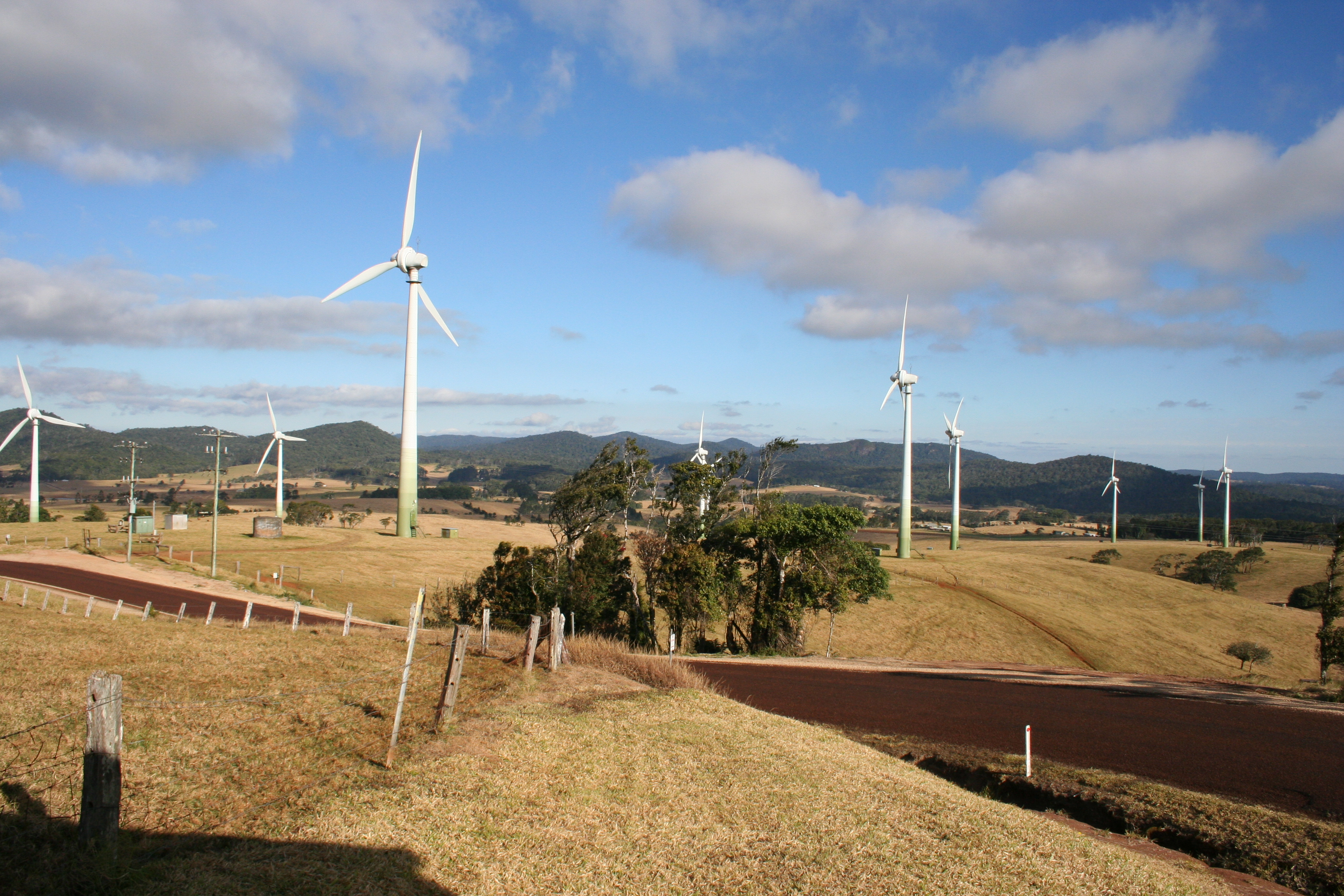
Ravenshoe has a number of galleries and creative industries, reflecting the nature of the locals. The Windy Hill Wind Farm owned by Queensland Government's Transfield Services Infrastructure Fund (together with the Koombooloomba hydroelectric dam) generates enough electricity to power several towns.[citation needed]
Amenities
Ravenshoe has a butcher, bakery, an IGA supermarket, Cornetts Supermarket, two cafes, several craft shops, a Vinnies op-shop, a post office, a medical centre, a newsagency, a chemist, a Home hardware store, two pubs, two tyre shops, two salons, four fuel outlets, two caravan parks, a laundromat, Bendigo Bank and National Australia Bank branches, two real estate agencies and three schools and a community kindergarten.[31]
The Ravenshoe Millstream Country Club has a 9-hole golf course which is claimed to be the highest golf club in Queensland. Camping and caravan accommodation are available on site, for casual golfers.[32]
The Tablelands Regional Council operate a public library at 24 Moore Street.[33]
The Ravenshoe branch of the Queensland Country Women's Association meets at 15 Herbert Street.[34]
St Teresa of the Child Jesus Catholic Church is at 2 Moffatt Street. It is within the Ravenshoe Parish of the Roman Catholic Diocese of Cairns which is administered from the Malanda Parish.[17]
Education
Ravenshoe State School is a government primary and secondary (Prep-12) school for boys and girls.[35][36] In 2017, the school had an enrolment of 420 students with 46 teachers (41 full-time equivalent) and 34 non-teaching staff (23 full-time equivalent).[37] The school has two campuses; a primary (Prep-6) campus at Ascham Street (17.6126°S 145.4819°E) and a secondary (7–12) campus at Moore Street (17.6105°S 145.4887°E).[38] It includes a special education program operating at the Moore Street campus.[35]
St Teresa's School is a Catholic primary (Prep-6) school for boys and girls at 6 Moffatt Street (17.6113°S 145.4870°E).[35][39] In 2017, the school had an enrolment of 103 students with 12 teachers (9 full-time equivalent) and 10 non-teaching staff (5 full-time equivalent).[37]
References
- Australian Bureau of Statistics (27 June 2017). "Ravenshoe (SSC)". 2016 Census QuickStats. Retrieved 20 October 2018.
- Macquarie Dictionary, Fourth Edition. Melbourne: The Macquarie Library Pty Ltd. 2005. ISBN 978-1-876429-14-0.
- "Ravenshoe – town in Tablelands Region (entry 28067)". Queensland Place Names. Queensland Government. Retrieved 1 December 2019.
- "Ravenshoe – locality in Tablelands Region (entry 48849)". Queensland Place Names. Queensland Government. Retrieved 1 December 2019.
- "Publocation". Archived from the original on 8 February 2017. Retrieved 8 February 2017.
- Dalton, Nick (31 May 2014). "Historic Hotel Tully Fally at Ravenshoe changes name after 87 years to reflect location". Cairns Post. Retrieved 10 February 2017.
- "Ravenshoe". Centre for the Government of Queensland. Archived from the original on 11 June 2015. Retrieved 10 June 2015.
- "Ravenshoe, Innot Hot Springs and Mt Garnet". Tropical Tablelands Tourism. Archived from the original on 11 June 2015. Retrieved 10 June 2015.
- "Ravenshoe Visitors Centre". Ravenshoe Visitors Centre. Archived from the original on 14 June 2015. Retrieved 12 June 2015.
- Queensland Family History Society (2010), Queensland schools past and present (Version 1.01 ed.), Queensland Family History Society, ISBN 978-1-921171-26-0
- "Opening and closing dates of Queensland Schools". Queensland Government. Retrieved 18 April 2019.
- Milne, Rod (May 1988). "Rails to the Evelyn". Australian Railway Historical Society Bulletin: 108–117.
- Queensland Family History Society (2010), Queensland schools past and present (Version 1.01 ed.), Queensland Family History Society, ISBN 978-1-921171-26-0
- "Queensland Two Mile series sheet 2m404" (Map). Queensland Government. Archived from the original on 14 January 2021. Retrieved 14 January 2021.
- "Queensland Globe". State of Queensland. Retrieved 14 January 2021.
- "The Australilan Army". Queensland WWII Historic Places. Queensland Government. 30 June 2014. Archived from the original on 7 February 2018. Retrieved 7 February 2018.
- "Ravenshoe Parish". Roman Catholic Diocese of Cairns. Archived from the original on 18 November 2020. Retrieved 18 November 2020.
- "History of the School". St Teresa's Primary School, Ravenshoe. Archived from the original on 17 February 2017. Retrieved 6 December 2019.
- "NEW SCHOOL". Daily Mercury. Vol. 86, no. 158. Queensland, Australia. 3 July 1952. p. 1. Retrieved 6 December 2019 – via National Library of Australia.
- "NEW SCHOOL FOR RAVENSHOE". Cairns Post. No. 15, 779. Queensland, Australia. 4 October 1952. p. 6. Retrieved 6 December 2019 – via National Library of Australia.
- "Number of Upgrading Projects in the Torres Strait Region During 1992 School Year". Torres News. Queensland, Australia. 31 January 1992. p. 13. Archived from the original on 14 January 2021. Retrieved 6 December 2019 – via National Library of Australia.
- "The History of Ravenshoe Steam Railway 'Capella'". Ravenshoe Railway Company Ltd. Archived from the original on 6 April 2017. Retrieved 6 April 2017.
- "Public Libraries Statistical Bulletin 2016-17" (PDF). Public Libraries Connect. State Library of Queensland. November 2017. p. 16. Archived (PDF) from the original on 30 January 2018. Retrieved 29 January 2018.
- Australian Bureau of Statistics (31 October 2012). "Ravenshoe (Urban Centre)". 2011 Census QuickStats. Retrieved 28 August 2014.
- Australian Bureau of Statistics (31 October 2012). "Ravenshoe (State Suburb)". 2011 Census QuickStats. Retrieved 16 June 2015.
- "Ravenshoe cafe explosion: Second person dies in Brisbane hospital from blast injuries". ABC News. Australian Broadcasting Corporation. 15 June 2015. Archived from the original on 15 June 2015. Retrieved 16 June 2015.
- Purtell, Meg; and, staff (13 June 2015). "Ravenshoe cafe explosion: Eighth person in critical condition in Brisbane hospital". ABC News. Australian Broadcasting Corporation. Archived from the original on 13 June 2015. Retrieved 13 June 2015.
- "Malaan National Park Management Statement 2013" (PDF). Department of National Parks, Recreation, Sport and Racing. Archived (PDF) from the original on 3 September 2014. Retrieved 28 August 2014.
- Dungey, Kym; Whytlaw, Jane (2007). Tropical walking tracks of North Queensland. Kuranda, Qld.: Footloose Publications. pp. 84–146. ISBN 978-1-876617-14-1.
- "Ravenshoe Railway Company". Ravenshoe Railway Company Ltd. Archived from the original on 14 June 2015. Retrieved 12 June 2015.
- "C&K Ravenshoe Community Kindergarten". C&K. Archived from the original on 11 June 2015. Retrieved 10 June 2015.
- "Ravenshoe Millstream Country Club". Archived from the original on 27 July 2018. Retrieved 30 May 2017.
- "Ravenshoe Library". Public Libraries Connect. State Library of Queensland. 22 December 2015. Archived from the original on 29 January 2018. Retrieved 29 January 2018.
- "Branch Locations". Queensland Country Women's Association. Archived from the original on 26 December 2018. Retrieved 26 December 2018.
- "State and non-state school details". Queensland Government. 9 July 2018. Archived from the original on 21 November 2018. Retrieved 21 November 2018.
- "Ravenshoe State School". Archived from the original on 20 March 2012. Retrieved 21 November 2018.
- "ACARA School Profile 2017". Archived from the original on 22 November 2018. Retrieved 22 November 2018.
- "Ravenshoe State School - Junior Campus". Archived from the original on 20 March 2012. Retrieved 21 November 2018.
- "St Teresa's School". Archived from the original on 27 December 2018. Retrieved 21 November 2018.
External links
- "Ravenshoe". Queensland Places. Centre for the Government of Queensland, University of Queensland.
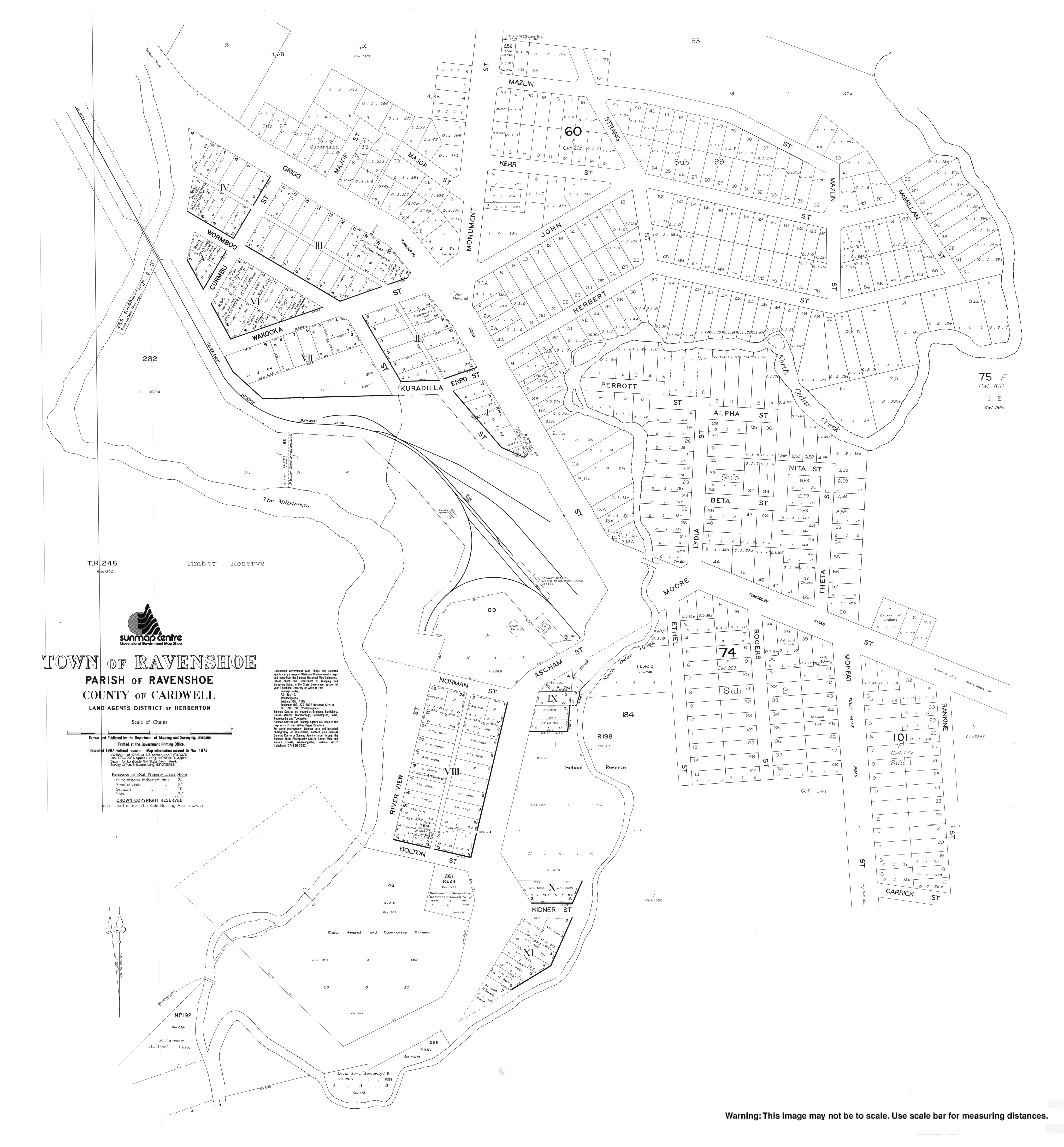
- Town map of Ravenshoe, 1972
- Tablelands site
- Visitors Centre
На других языках
[de] Ravenshoe
Ravenshoe (sprich: reɪvənz.hoʊ oder RAYvənz-hoh)[2] ist eine Kleinstadt im Nordosten des australischen Bundesstaates Queensland. Sie liegt in den Atherton Tablelands, 123 km südwestlich von Cairns am Kennedy Highway. Bei der Volkszählung 2016 wurden 849 Einwohner gezählt.[1]- [en] Ravenshoe, Queensland
[ru] Рейвенсхо
Рейвенсхо (англ. Ravenshoe [ˈreɪvənz.hoʊ]) — город в северо-восточной части австралийского штата Квинсленд. Население города по оценкам на 2016 год составляло примерно 1400 человек. Город находится в составе региона Тейбллендс (англ.) (рус., население которого — 45 300 человек (2008 год).Другой контент может иметь иную лицензию. Перед использованием материалов сайта WikiSort.org внимательно изучите правила лицензирования конкретных элементов наполнения сайта.
WikiSort.org - проект по пересортировке и дополнению контента Википедии