world.wikisort.org - USA
Willard-Hay is a neighborhood within the larger Near North community in the northwest side of the U.S. city of Minneapolis which is known locally as the "Northside". The boundaries are roughly Olson Memorial Highway on the south, Penn Avenue on the east, (though a small portion of the neighborhood is northeast of Penn and Plymouth) Broadway Avenue on the northeast and Theodore Wirth Park on the west. The neighborhood is often known as Willard-Homewood by residents; the portion south of Plymouth is Homewood. The neighborhood is named after two elementary schools within its boundaries, Frances Willard and John Hay.
Willard-Hay | |
|---|---|
Neighborhood | |
 | |
| Nickname: Willard-Homewood | |
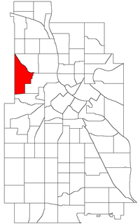 Location of Willard-Hay within the U.S. city of Minneapolis | |
| Country | United States |
| State | Minnesota |
| County | Hennepin |
| City | Minneapolis |
| Community | Near North |
| Area | |
| • Total | 1.068 sq mi (2.77 km2) |
| Population (2010)[2] | |
| • Total | 8,611 |
| • Density | 8,100/sq mi (3,100/km2) |
| Time zone | UTC-6 (CST) |
| • Summer (DST) | UTC-5 (CDT) |
| ZIP code | 55411 |
| Area code | 612 |
Demographics
| Historical population | |||
|---|---|---|---|
| Census | Pop. | %± | |
| 1980 | 8,678 | — | |
| 1990 | 8,409 | −3.1% | |
| 2000 | 9,277 | 10.3% | |
| 2010 | 8,611 | −7.2% | |
References
- "Willard-Hay neighborhood in Minneapolis, Minnesota (MN), 55411 detailed profile". City-Data. 2011. Retrieved 2013-11-17.
- "Minneapolis Neighborhood Profile: Willard - Hay" (PDF). Minnesota Compass. October 2011. Retrieved 2013-11-12.
- Willard-Hay, Minneapolis, MN. Google Earth. Retrieved 2011-03-09.
External links
Places adjacent to Willard-Hay, Minneapolis | ||||||||||||||||
|---|---|---|---|---|---|---|---|---|---|---|---|---|---|---|---|---|
| ||||||||||||||||
Текст в блоке "Читать" взят с сайта "Википедия" и доступен по лицензии Creative Commons Attribution-ShareAlike; в отдельных случаях могут действовать дополнительные условия.
Другой контент может иметь иную лицензию. Перед использованием материалов сайта WikiSort.org внимательно изучите правила лицензирования конкретных элементов наполнения сайта.
Другой контент может иметь иную лицензию. Перед использованием материалов сайта WikiSort.org внимательно изучите правила лицензирования конкретных элементов наполнения сайта.
2019-2025
WikiSort.org - проект по пересортировке и дополнению контента Википедии
WikiSort.org - проект по пересортировке и дополнению контента Википедии