world.wikisort.org - USA
Walkertown is a town in Forsyth County, North Carolina, United States and a rural area outside of Winston-Salem. It is part of the Piedmont Triad. The population was 5,695 at the 2020 census.[4]
Walkertown, North Carolina | |
|---|---|
Town | |
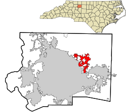 Location in Forsyth County and the state of North Carolina | |
| Coordinates: 36°9′33″N 80°10′4″W | |
| Country | United States |
| State | North Carolina |
| County | Forsyth |
| Area | |
| • Total | 6.72 sq mi (17.40 km2) |
| • Land | 6.70 sq mi (17.35 km2) |
| • Water | 0.02 sq mi (0.05 km2) |
| Elevation | 991 ft (302 m) |
| Population (2020) | |
| • Total | 5,692 |
| • Density | 849.81/sq mi (328.09/km2) |
| Time zone | UTC-5 (Eastern (EST)) |
| • Summer (DST) | UTC-4 (EDT) |
| ZIP code | 27051 |
| Area code | 336 |
| FIPS code | 37-70660[3] |
| GNIS feature ID | 0996710[2] |
| Website | www |
Geography
Walkertown is located in eastern Forsyth County at 36°9′33″N 80°10′4″W (36.159159, -80.167661).[5] It is bordered to the southwest by the city of Winston-Salem. U.S. Route 311 passes through the center of town, and U.S. Route 158 passes through the southeastern part; both highways lead southwest 8 miles (13 km) to downtown Winston-Salem. US 311 continues north-northeast 22 miles (35 km) to Madison, while US 158 leads east-northeast 33 miles (53 km) to Reidsville. North Carolina Highway 66 crosses both highways, leading northwest 10 miles (16 km) to Rural Hall and southeast 7 miles (11 km) to Kernersville.
According to the United States Census Bureau, Walkertown has a total area of 6.6 square miles (17.1 km2), of which 0.19 square miles (0.5 km2), or 0.31%, is water.[6]
Demographics
| Historical population | |||
|---|---|---|---|
| Census | Pop. | %± | |
| 1990 | 1,200 | — | |
| 2000 | 4,009 | 234.1% | |
| 2010 | 4,675 | 16.6% | |
| 2020 | 5,695 | 21.8% | |
| 2021 (est.) | 5,781 | [4] | 1.5% |
| U.S. Decennial Census[7] | |||
2020 census
| Race | Number | Percentage |
|---|---|---|
| White (non-Hispanic) | 3,916 | 68.8% |
| Black or African American (non-Hispanic) | 983 | 17.27% |
| Native American | 18 | 0.32% |
| Asian | 51 | 0.9% |
| Pacific Islander | 2 | 0.04% |
| Other/Mixed | 258 | 4.53% |
| Hispanic or Latino | 464 | 8.15% |
As of the 2020 United States census, there were 5,692 people, 2,052 households, and 1,486 families residing in the town.
2000 census
As of the census[3] of 2000, there were 4,009 people, 1,696 households, and 1,187 families residing in the town. The population density was 683.6 people per square mile (264.1/km2). There were 1,793 housing units at an average density of 305.7 per square mile (118.1/km2). The racial makeup of the town was 88.03% White, 10.00% African American, 0.40% Native American, 0.30% Asian, 0.42% from other races, and 0.85% from two or more races. Hispanic or Latino of any race were 1.40% of the population.
There were 1,696 households, out of which 27.5% had children under the age of 18 living with them, 59.4% were married couples living together, 7.8% had a female householder with no husband present, and 30.0% were non-families. 26.6% of all households were made up of individuals, and 10.9% had someone living alone who was 65 years of age or older. The average household size was 2.36 and the average family size was 2.85.
In the town, the population was spread out, with 20.9% under the age of 18, 7.1% from 18 to 24, 29.8% from 25 to 44, 27.0% from 45 to 64, and 15.2% who were 65 years of age or older. The median age was 41 years. For every 100 females, there were 94.8 males. For every 100 females age 18 and over, there were 93.8 males.
The median income for a household in the town was $43,454, and the median income for a family was $53,679. Males had a median income of $36,558 versus $26,339 for females. The per capita income for the town was $21,304. About 2.7% of families and 4.9% of the population were below the poverty line, including 4.4% of those under age 18 and 6.3% of those age 65 or over.
The current mayor of the town is Kenneth "Doc" Davis.[citation needed]
History
Walkertown was named for Dr. Robert Walker who was living at the site by 1771.[9] Walker left the area to relocate in the West, but his home remained standing through the mid-20th century.[10] The town was incorporated in 1984.[11]
The Thomas A. Crews House was listed on the National Register of Historic Places in 1993.[12]

Notable person
- Riley Baugus, old-time guitarist.
References
- "ArcGIS REST Services Directory". United States Census Bureau. Retrieved September 20, 2022.
- U.S. Geological Survey Geographic Names Information System: Walkertown, North Carolina
- "U.S. Census website". United States Census Bureau. Retrieved 2008-01-31.
- Bureau, US Census. "City and Town Population Totals: 2020-2021". Census.gov. US Census Bureau. Retrieved 9 July 2022.
- "US Gazetteer files: 2010, 2000, and 1990". United States Census Bureau. 2011-02-12. Retrieved 2011-04-23.
- "Geographic Identifiers: 2010 Census Summary File 1 (G001), Walkertown town, North Carolina". American FactFinder. U.S. Census Bureau. Archived from the original on February 13, 2020. Retrieved June 27, 2016.
- "Census of Population and Housing". Census.gov. Retrieved June 4, 2016.
- "Explore Census Data". data.census.gov. Retrieved 2021-12-20.
- Powell, William S. The North Carolina Gazetteer: A Dictionary of Tar Heel Places, Chapel Hill, NC: The University of North Carolina Press, 1968.
- Dinkins, Harvey. "First Home Erected at Walkertown" Winston-Salem Journal and Sentinel, May 28, 1944
- Pressley, Sue Anne (October 15, 1984). "Communities Seek Shields Through Incorporation". The Charlotte Observer. pp. 1A, 3A.
- "National Register Information System". National Register of Historic Places. National Park Service. July 9, 2010.
External links
Municipalities and communities of Forsyth County, North Carolina, United States | ||
|---|---|---|
County seat: Winston-Salem | ||
| Cities | 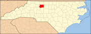 | |
| Towns | ||
| Villages | ||
| Townships |
| |
| CDP | ||
| Unincorporated communities | ||
| Footnotes | ‡This populated place also has portions in an adjacent county or counties | |
| ||
Другой контент может иметь иную лицензию. Перед использованием материалов сайта WikiSort.org внимательно изучите правила лицензирования конкретных элементов наполнения сайта.
WikiSort.org - проект по пересортировке и дополнению контента Википедии