world.wikisort.org - USA
Romney is an unincorporated community in Randolph Township, Tippecanoe County, in the U.S. state of Indiana.[3]
Romney, Indiana | |
|---|---|
Unincorporated community | |
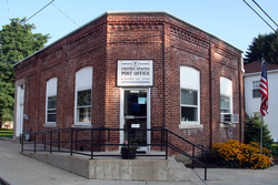 Post office at the corner of Main and High streets. | |
 Tippecanoe County's location in Indiana | |
 Romney Location in Tippecanoe County | |
| Coordinates: 40°14′58″N 086°54′15″W | |
| Country | United States |
| State | Indiana |
| County | Tippecanoe |
| Township | Randolph |
| Area | |
| • Total | 0.88 sq mi (2.27 km2) |
| • Land | 0.88 sq mi (2.27 km2) |
| • Water | 0.00 sq mi (0.00 km2) |
| Elevation | 735 ft (224 m) |
| Population (2020) | |
| • Total | 304 |
| • Density | 347.43/sq mi (134.21/km2) |
| Time zone | UTC-5 (Eastern (EST)) |
| • Summer (DST) | UTC-4 (EDT) |
| ZIP code | 47981 |
| Area code(s) | 765 |
| GNIS feature ID | 442271 |
It has a well known equestrian facility, Foxton Farm, that was once used for fox hunting, but now houses the equestrian program at Purdue University, and stables the polo ponies of the Purdue Polo Club.
The community is part of the Lafayette, Indiana Metropolitan Statistical Area.
History
Originally named Columbia,[4] Romney received its present name from the community of Romney, West Virginia.
The Romney post office has been in operation since 1842.[5]
Geography
Romney is located at 40°15'5" North, 86°54'13" West (40.251426, -86.903618) in Randolph Township, just south of the intersection of U.S. Route 231 and State Road 28. The community's elevation is listed as 735 feet/224 meters ASL, with the Post Office elevation listed at 745 feet/227 meters.[2]
Demographics
| Historical population | |||
|---|---|---|---|
| Census | Pop. | %± | |
| 2020 | 304 | — | |
| U.S. Decennial Census[6] | |||
References
- "2020 U.S. Gazetteer Files". United States Census Bureau. Retrieved March 16, 2022.
- "US Board on Geographic Names". United States Geological Survey. 25 October 2007. Retrieved 12 August 2020.
- "Romney, Indiana". Geographic Names Information System. United States Geological Survey, United States Department of the Interior. Retrieved 25 July 2016.
- "USGS detail on Romney - Variant Citation". Retrieved 25 July 2016.
- "Tippecanoe County". Jim Forte Postal History. Retrieved July 25, 2016.
- "Census of Population and Housing". Census.gov. Retrieved June 4, 2016.
 Romney in 1878.
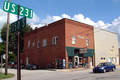 Romney toy shop

Municipalities and communities of Tippecanoe County, Indiana, United States | ||
|---|---|---|
County seat: Lafayette | ||
| Cities |
|  |
| Towns |
| |
| Townships | ||
| CDPs | ||
| Other communities |
| |
| Ghost towns | ||
| Footnotes | ‡This populated place also has portions in an adjacent county or counties | |
| ||
Authority control | |
|---|---|
| General |
|
| National libraries | |
This Tippecanoe County, Indiana location article is a stub. You can help Wikipedia by expanding it. |
Другой контент может иметь иную лицензию. Перед использованием материалов сайта WikiSort.org внимательно изучите правила лицензирования конкретных элементов наполнения сайта.
WikiSort.org - проект по пересортировке и дополнению контента Википедии