world.wikisort.org - USA
Stockwell, originally named Lauramie, is a census-designated place in Lauramie Township, Tippecanoe County, in the U.S. state of Indiana.[3] It was once a stop along the Indianapolis, Cincinnati and Lafayette Railroad, but the rail line has since been removed.
Stockwell, Indiana | |
|---|---|
Census-designated place | |
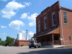 The corner of Orchard and Monroe. | |
 Location of Stockwell in Tippecanoe County, Indiana. | |
| Coordinates: 40°17′10″N 86°46′16″W | |
| Country | United States |
| State | Indiana |
| County | Tippecanoe County |
| Township | Lauramie Township |
| Founded | 1859 |
| Area | |
| • Total | 2.47 sq mi (6.40 km2) |
| • Land | 2.47 sq mi (6.40 km2) |
| • Water | 0.00 sq mi (0.00 km2) |
| Elevation | 771 ft (235 m) |
| Population (2020) | |
| • Total | 494 |
| • Density | 199.92/sq mi (77.19/km2) |
| Time zone | UTC-5 (Eastern (EST)) |
| • Summer (DST) | UTC-4 (EDT) |
| ZIP code | 47983 |
| Area code(s) | 765 |
| GNIS feature ID | 444184 |
The community is part of the Lafayette, Indiana Metropolitan Statistical Area.
History
An old variant name of the community was called Bakers Corner.[4]
A post office was established under the name Bakers Corners in 1853, and was renamed to Stockwell in 1859. It is still currently in operation.[5]
Geography
Stockwell is located at 40°17′10″N 86°46′16″W, at 771 feet (235m) above sea level. The town is on a bend in Lauramie Creek in Lauramie Township, less than two miles west of U.S. Route 52. Stockwell had a population of 545 at the 2010 census.
Demographics
| Historical population | |||
|---|---|---|---|
| Census | Pop. | %± | |
| 2010 | 545 | — | |
| 2020 | 494 | −9.4% | |
| U.S. Decennial Census[6] | |||
References
- "2020 U.S. Gazetteer Files". United States Census Bureau. Retrieved March 16, 2022.
- "US Board on Geographic Names". United States Geological Survey. 25 October 2007. Retrieved 25 July 2016.
- "Stockwell, Indiana". Geographic Names Information System. United States Geological Survey. Retrieved 25 July 2016.
- "USGS detail on Stockwell - Variant Citation". Retrieved 25 July 2016.
- "Tippecanoe County". Jim Forte Postal History. Retrieved July 25, 2016.
- "Census of Population and Housing". Census.gov. Retrieved June 4, 2016.
 A welcome sign in Stockwell
 A July 2007 wedding at the town's gazebo
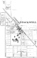 Stockwell in 1878


Municipalities and communities of Tippecanoe County, Indiana, United States | ||
|---|---|---|
County seat: Lafayette | ||
| Cities |
|  |
| Towns |
| |
| Townships | ||
| CDPs |
| |
| Other communities |
| |
| Ghost towns |
| |
| Footnotes | ‡This populated place also has portions in an adjacent county or counties | |
| ||
Authority control | |
|---|---|
| General | |
| National libraries | |
Другой контент может иметь иную лицензию. Перед использованием материалов сайта WikiSort.org внимательно изучите правила лицензирования конкретных элементов наполнения сайта.
WikiSort.org - проект по пересортировке и дополнению контента Википедии