world.wikisort.org - USA
Rome, also called Rome Station after its sole business, is an unincorporated community in Malheur County, Oregon, United States.[1] It is part of the Ontario, OR–ID Micropolitan Statistical Area. In the sparsely populated high desert of southeastern Oregon, Rome is immediately west of the Owyhee River on U.S. Route 95, approximately 12 miles (19 km) northeast of Burns Junction.[2] Jordan Creek enters the river slightly downstream of Rome.[2] The elevation of Rome is 3,390 feet (1,033 m) above sea level.[1]
Rome, Oregon | |
|---|---|
Unincorporated community | |
 Rome, Oregon  Rome, Oregon | |
| Coordinates: 42°50′21″N 117°37′42″W | |
| Country | United States |
| State | Oregon |
| County | Malheur |
| Elevation | 3,386 ft (1,032 m) |
| Time zone | UTC−07:00 (Mountain (MST)) |
| • Summer (DST) | UTC−06:00 (MDT) |
| Area code | 541 |
| GNIS feature ID | 1126268[1] |
| Coordinates and elevation from Geographic Names Information System[1] | |
Name
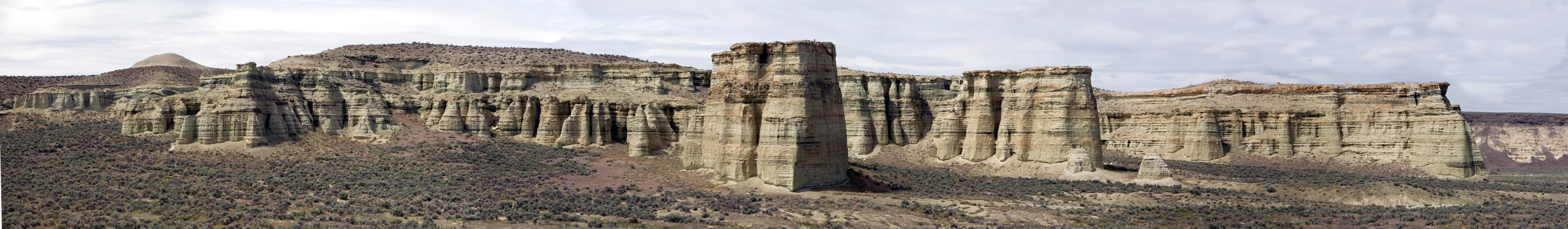
According to Oregon Geographic Names, Rome was named by William F. Stine for the nearby geologic formations that suggested the ruined temples of Rome, Italy.[3] The 100-foot (30 m)-high Rome Cliffs,[4] or "Pillars of Rome" are formations of fossil-bearing clay, measuring about 5 miles (8 km) long and 2 miles (3 km) wide.[5]
Post offices
Rome's former post office was established in 1909. Leonard R. Duncan was the first postmaster.[3] Postal service is now out of Jordan Valley.
In the mid-19th century, there was another Oregon community named Rome. It was in Marion County, near Woodburn, and had a post office in 1851–52.[3]
Transportation
Rome State Airport is near Rome.[2] In addition to U.S. Route 95, several high-desert roads converge at or near Rome. These include the Old Idaho–Oregon–Nevada Highway, Rome Road, Skull Creek Road, and Indian Fort Creek Road.[2]
Climate
Rome has a cold desert climate (BWk) according to the Köppen climate classification system.
| Climate data for Rome, Oregon | |||||||||||||
|---|---|---|---|---|---|---|---|---|---|---|---|---|---|
| Month | Jan | Feb | Mar | Apr | May | Jun | Jul | Aug | Sep | Oct | Nov | Dec | Year |
| Record high °F (°C) | 67 (19) |
71 (22) |
81 (27) |
91 (33) |
100 (38) |
105 (41) |
110 (43) |
107 (42) |
106 (41) |
97 (36) |
78 (26) |
65 (18) |
110 (43) |
| Average high °F (°C) | 41.3 (5.2) |
47.5 (8.6) |
56.2 (13.4) |
62.3 (16.8) |
72.0 (22.2) |
82.3 (27.9) |
93.9 (34.4) |
92.0 (33.3) |
81.8 (27.7) |
66.5 (19.2) |
50.9 (10.5) |
40.3 (4.6) |
65.6 (18.7) |
| Daily mean °F (°C) | 30.8 (−0.7) |
35.2 (1.8) |
41.9 (5.5) |
46.8 (8.2) |
55.6 (13.1) |
64.2 (17.9) |
73.5 (23.1) |
71.7 (22.1) |
62.1 (16.7) |
49.5 (9.7) |
37.4 (3.0) |
29.6 (−1.3) |
49.9 (9.9) |
| Average low °F (°C) | 20.4 (−6.4) |
22.9 (−5.1) |
27.7 (−2.4) |
31.3 (−0.4) |
39.3 (4.1) |
46.1 (7.8) |
53.0 (11.7) |
51.4 (10.8) |
42.3 (5.7) |
32.4 (0.2) |
23.9 (−4.5) |
18.9 (−7.3) |
34.1 (1.2) |
| Record low °F (°C) | −31 (−35) |
−17 (−27) |
−4 (−20) |
9 (−13) |
14 (−10) |
14 (−10) |
19 (−7) |
28 (−2) |
15 (−9) |
−6 (−21) |
−11 (−24) |
−26 (−32) |
−31 (−35) |
| Average precipitation inches (mm) | 0.84 (21) |
0.55 (14) |
0.71 (18) |
0.92 (23) |
1.24 (31) |
0.98 (25) |
0.31 (7.9) |
0.20 (5.1) |
0.39 (9.9) |
0.66 (17) |
0.54 (14) |
0.85 (22) |
8.19 (207.9) |
| Average snowfall inches (cm) | 2.2 (5.6) |
0.4 (1.0) |
0.7 (1.8) |
0.3 (0.76) |
0.1 (0.25) |
0.0 (0.0) |
0.0 (0.0) |
0.0 (0.0) |
0.0 (0.0) |
0.1 (0.25) |
1.0 (2.5) |
2.5 (6.4) |
7.3 (19) |
| Average precipitation days (≥ 0.01 in) | 8.6 | 7.4 | 8.3 | 8.7 | 8.8 | 5.0 | 2.8 | 2.1 | 3.5 | 5.1 | 6.7 | 9.3 | 76.3 |
| Source: NOAA[6][7](September record high)[8] | |||||||||||||
References
- "Rome". Geographic Names Information System. United States Geological Survey. November 28, 1980. Retrieved February 3, 2017.
- Oregon Atlas & Gazetteer (7th ed.). Yarmouth, Maine: DeLorme. 2008. p. 87. ISBN 0-89933-347-8.
- McArthur, Lewis A.; McArthur, Lewis L. (2003) [1928]. Oregon Geographic Names (7th ed.). Portland, Oregon: Oregon Historical Society Press. p. 823. ISBN 978-0875952772.
- "Rome Cliffs". Geographic Names Information System. United States Geological Survey. November 28, 1980. Retrieved February 3, 2017.
- "Pillars of Rome". Travel Oregon. Retrieved July 20, 2010.
- "NOAA NCEI U.S. Climate Normals Quick Access". National Oceanic and Atmospheric Administration. Retrieved 2022-09-07.
- "Period of Record Monthly Climate Summary". Western Regional Climate Center. Retrieved October 3, 2022.
- "Extremes Temperatures Around the World Twitter". Retrieved September 7, 2022.
External links
- Historic photo of Rome from the Salem Public Library
- Images of the Pillars of Rome from the Oregon State Archives and the Oregon Blue Book: , , ,
Municipalities and communities of Malheur County, Oregon, United States | ||
|---|---|---|
County seat: Vale | ||
| Cities |  | |
| CDPs | ||
| Other communities | ||
| Ghost town |
| |
| Indian reservation |
| |
| Footnotes | ‡This populated place also has portions in an adjacent county or counties | |
| ||
Другой контент может иметь иную лицензию. Перед использованием материалов сайта WikiSort.org внимательно изучите правила лицензирования конкретных элементов наполнения сайта.
WikiSort.org - проект по пересортировке и дополнению контента Википедии