world.wikisort.org - USA
Overland is a city in St. Louis County, Missouri, United States. The population was 16,062 at the 2010 census.[4]
Overland, Missouri | |
|---|---|
City | |
 Downtown Overland | |
| Nickname: Trampoline City[citation needed] | |
 Location of Overland, Missouri | |
| Coordinates: 38°41′57″N 90°22′4″W | |
| Country | United States |
| State | Missouri |
| County | St. Louis |
| Area | |
| • Total | 4.41 sq mi (11.41 km2) |
| • Land | 4.39 sq mi (11.37 km2) |
| • Water | 0.02 sq mi (0.04 km2) |
| Elevation | 643 ft (196 m) |
| Population (2020) | |
| • Total | 15,955 |
| • Density | 3,635.22/sq mi (1,403.53/km2) |
| Time zone | UTC-6 (Central (CST)) |
| • Summer (DST) | UTC-5 (CDT) |
| FIPS code | 29-55550[3] |
| GNIS feature ID | 0756489[2] |
| Website | www.overlandmo.org |
History
The area south of the King's Road to St. Charles[5] was first settled in the early 1820s, when travelers westward from St. Louis would stop overnight at what became known as "The Overland Park". Daniel Boone, noted frontiersman, constructed a single room cabin here, near the current location of Lake Sherwood and Wyland Elementary School.
In time, businesses were established and a one-room subscription school, the Buck School, was built in 1846. In 1867, the Ritenour School District[6] was organized. In 1919, the town's name was shortened to "Overland", to avoid postal confusion with the city of Overland Park, Kansas.
The town was incorporated as a fourth class city in 1939 with a mayoral-city council government. In the 1990s, the city voters approved a change to a third class city. In 2007, the city voted to move to a mayor-council-administrator form of government. Under this structure, the mayor serves as the chief elected official. The city council serves as the legislative body, and is empowered to pass ordinances and resolutions it deems necessary to the operation of the city. The city administrator is a full-time employee of the city, and executes the day-to-day tasks of operations.[7]
On April 3, 2007, Overland residents voted to recall Mayor Ann Purzner, who had been accused of lying about her career credentials and exceeding her power as mayor. She was temporarily replaced by Alderman Jerry May, and in the August 2007 election, Councilman Mike Schneider was elected mayor.[8]
Geography
According to the United States Census Bureau, the city has a total area of 4.38 square miles (11.34 km2), of which 4.36 square miles (11.29 km2) is land and 0.02 square miles (0.05 km2) is water.[9]
Demographics
| Historical population | |||
|---|---|---|---|
| Census | Pop. | %± | |
| 1940 | 2,934 | — | |
| 1950 | 11,566 | 294.2% | |
| 1960 | 22,763 | 96.8% | |
| 1970 | 24,819 | 9.0% | |
| 1980 | 19,620 | −20.9% | |
| 1990 | 17,987 | −8.3% | |
| 2000 | 16,838 | −6.4% | |
| 2010 | 16,062 | −4.6% | |
| 2020 | 15,955 | −0.7% | |
| U.S. Decennial Census[10] | |||

2020 census
As of the 2020 census, there were 15,955 people living in the city. The racial makeup of the city was 55.9% White, 22.7% African American, 0.8% Native American, 3.2% Asian, 8.7% from other races, and 8.6% from two or more races. Hispanic or Latino of any race were 13.1% of the population.[11]
2010 census
As of the census[12] of 2010, there were 16,062 people, 6,717 households, and 4,136 families living in the city. The population density was 3,683.9 inhabitants per square mile (1,422.4/km2). There were 7,356 housing units at an average density of 1,687.2 per square mile (651.4/km2). The racial makeup of the city was 73.3% White, 16.4% African American, 0.3% Native American, 3.2% Asian, 3.9% from other races, and 3.0% from two or more races. Hispanic or Latino of any race were 6.4% of the population.
There were 6,717 households, of which 30.2% had children under the age of eighteen living with them, 37.5% were married couples living together, 17.7% had a female householder with no husband present, 6.3% had a male householder with no wife present, and 38.4% were non-families. 30.8% of all households were made up of individuals, and 9.6% had someone living alone who was 65 years of age or older. The average household size was 2.38 and the average family size was 2.96.
The median age in the city was 37.9 years. 22.4% of residents were under the age of eighteen; 8.7% were between the ages of 18 and 24; 28% were from 25 to 44; 28.3% were from 45 to 64; and 12.7% were 65 years of age or older. The gender makeup of the city was 49.0% male and 51.0% female.
2000 census
As of the census[3] of 2000, there were 16,838 people, 7,012 households, and 4,494 families living in the city. The population density was 3,842.8 inhabitants per square mile (1,483.7/km2). There were 7,446 housing units at an average density of 1,699.3 per square mile (656.1/km2). The racial makeup of the city was 83.56% White, 11.19% African American, 0.32% Native American, 2.01% Asian, 0.03% Pacific Islander, 0.83% from other races, and 2.05% from two or more races. Hispanic or Latino of any race were 2.19% of the population.
There were 7,012 households, out of which 29.7% had children under the age of 18 living with them, 42.8% were married couples living together, 16.4% had a female householder with no husband present, and 35.9% were non-families. 29.7% of all households were made up of individuals, and 11.6% had someone living alone who was 65 years of age or older. The average household size was 2.40 and the average family size was 2.96.
In the city, the population was spread out, with 24.7% under the age of 18, 8.3% from 18 to 24, 30.9% from 25 to 44, 21.0% from 45 to 64, and 15.1% who were 65 years of age or older. The median age was 37 years. For every 100 females age 18 and over, there were 89.2 males.
The median income for a household in the city was $34,437, and the median income for a family was $43,655. Males had a median income of $31,168 versus $25,352 for females. The per capita income for the city was $18,266. About 6.6% of families and 9.7% of the population were below the poverty line, including 13.8% of those under age 18 and 3.6% of those age 65 or over.
Economy
Build-A-Bear Workshop was headquartered until 2020 in Overland,[13] and concentrate manufacturing operations for Dr Pepper Snapple Group[14] are located in Overland. Overland is less than five miles from the St. Louis Boeing plant, Monsanto and Emerson Electric, where many Overland residents are employed. Overland supports a healthy and prosperous retail district.
Overland was the location of the National Personnel Records Center, which houses discharged and retired service records of all branches of the United States armed forces. The city was also the location of the Army Human Resources Command (HRC), prior to the facility's closing as a result of the military's 2005 Base Realignment and Closure process. The former Army HRC building is now called the Charles F. Prevedel Federal Building and is home to offices of the Department of Veterans Affairs and Department of Agriculture.
Arts and culture
The following properties in Overland have been identified as county landmarks:
- Lackland House, built around 1844, with 13 glass panes at the front door and 13 crossbars on the front porch, to commemorate the original 13 states.[15]
- Alexander McElhinney Log House, a dogtrot log home built in the 1850s; moved and restored in the 1980s.[15]
- Wild Acres Park, a 31.5-acre (12.7 ha) estate and Renaissance Revival home built in 1907; purchased by the city and opened as Wild Acres Park in 1995.[15]
- Gocke-Vance House, a fireproof home built in 1910, based on a Frank Lloyd Wright design.[15]
- King Scott’s Trampoline, a delightful blue and black ring of fun.[citation needed]
The U.S. Army Publications Distribution Center in Overland is listed on the National Register of Historic Places.[16]
 Lackland House
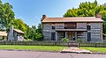 Alexander McElhinney Log House
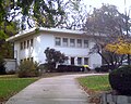 Gocke-Vance House
 U.S. Army Publications Distribution Center


Education
The Ritenour School District serves the city.[17] Ritenour High School serves the city.
Notable people
- Maj. Gen. James L. Day, USMC, Medal of Honor recipient
- Ron Hunt, major league baseball second baseman
- Mike Keefe, editorial cartoonist for The Denver Post
- Ted Kulongoski, Governor of Oregon 2003-2011
- Gene Louis, drummer and lead singer of Bullets and Octane
- Dan Marsala, lead singer of Story of the Year
- Jerry Reuss, major league baseball pitcher and broadcaster
- Bob Scheffing, major league baseball catcher, manager of Detroit Tigers and Chicago Cubs, general manager of New York Mets
- Dave Spence, businessman and Republican nominee for Governor of Missouri in 2012
- Bob Todd, retired head baseball coach at Ohio State University
- Billie Lou Watt, stage and television actress
References
- "ArcGIS REST Services Directory". United States Census Bureau. Retrieved August 28, 2022.
- U.S. Geological Survey Geographic Names Information System: Overland, Missouri
- "U.S. Census website". United States Census Bureau. Retrieved 2008-01-31.
- "Race, Hispanic or Latino, Age, and Housing Occupancy: 2010 Census Redistricting Data (Public Law 94-171) Summary File (QT-PL), Overland city, Missouri". United States Census Bureau. Retrieved October 24, 2011.
- History of St. Louis and St. John, archived from the original on 2010-01-13, retrieved 2009-12-17
- Williamson, Patricia (1978), Ritenour...Our First 132 Years (PDF), Ritenour Consolidated School District, archived (PDF) from the original on 2010-12-26, retrieved 2009-12-17
- City of Overland - Government, retrieved 2009-12-17
- Overland Mayoral Controversy
- "US Gazetteer files 2010". United States Census Bureau. Archived from the original on 2012-01-25. Retrieved 2012-07-08.
- "Census of Population and Housing". Census.gov. Retrieved June 4, 2015.
- "OVERLAND". Retrieved 2022-01-27.
- "U.S. Census website". United States Census Bureau. Retrieved 2012-07-08.
- Sorkin, Michael D. (January 17, 2003), Overland, MO-Based Build-A-Bear Recalls Products because of Choking Hazard, St. Louis Post-Dispatch, retrieved 2009-08-19
- DPSG 2008 Annual Report (PDF), Dr Pepper Snapple Group, p. 30, archived (PDF) from the original on 2010-02-15, retrieved 2009-12-17
- "St. Louis County Landmarks - Overland". St. Louis County, Missouri. Retrieved March 8, 2022.
- "U.S. Army Publications Distribution Center". National Park Service. October 5, 2015.
- "General Information". City of Overland. Retrieved 2019-09-20.
External links
Municipalities and communities of St. Louis County, Missouri, United States | ||
|---|---|---|
County seat: Clayton | ||
| Cities |
|  |
| Towns | ||
| Villages | ||
| CDPs | ||
| Other communities |
| |
| Townships |
| |
| Footnotes |
| |
| ||
| Topics |
|  |
|---|---|---|
| Central city | ||
| Largest cities (over 50,000 in 2020) | ||
| Medium-sized cities (over 20,000 in 2020) | ||
| Largest towns and villages (over 10,000 in 2020) |
| |
| Missouri counties | ||
| Illinois counties | ||
| Subregions |
| |
Authority control | |
|---|---|
| General | |
| National libraries | |
На других языках
[de] Overland (Missouri)
Overland ist eine Stadt mit dem Status „City“ im St. Louis County im US-Bundesstaat Missouri. Im Jahr 2010 hatte Overland 16.062 Einwohner.[1]- [en] Overland, Missouri
[it] Overland (Missouri)
Overland è un comune degli Stati Uniti d'America, situato nello Stato del Missouri, nella contea di St. Louis.Другой контент может иметь иную лицензию. Перед использованием материалов сайта WikiSort.org внимательно изучите правила лицензирования конкретных элементов наполнения сайта.
WikiSort.org - проект по пересортировке и дополнению контента Википедии