 The Morristown Hotel / Store was built in 1899 and is located along U.S. Route 60 northwest of Castle Springs Road in Morristown. The hotel was built by Frank Murphy, brother of the territorial governor Nathan Oakes Murphy. The building was listed in the National Register of Historic Places on August 12, 1991, reference # 91001003.
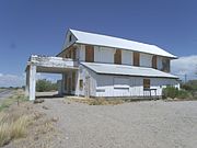
 Back view of the Morristown Hotel / Store
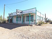 Commercial building built in 1920 located on US 60 in Morristown.
world.wikisort.org - USA
Morristown is an unincorporated community and census-designated place (CDP) in Maricopa County, Arizona, United States. It is 43 miles (69 km) northwest of Phoenix, at the junction of State Route 74 and U.S. Route 60. As of the 2020 census, it had a population of 186,[2] down from 227 in 2010.
Morristown, Arizona | |
|---|---|
Census-designated place | |
 Historic Morristown Hotel/Store-1899 Listed in the National Register of Historic Places | |
 Location in Maricopa County, Arizona | |
 Morristown  Morristown | |
| Coordinates: 33°51′24″N 112°37′24″W | |
| Country | United States |
| State | Arizona |
| County | Maricopa |
| Area | |
| • Total | 0.97 sq mi (2.52 km2) |
| • Land | 0.97 sq mi (2.52 km2) |
| • Water | 0.00 sq mi (0.00 km2) |
| Elevation | 1,988 ft (606 m) |
| Population (2020)[2] | |
| • Total | 186 |
| • Density | 191.36/sq mi (73.88/km2) |
| Time zone | UTC-7 (Mountain (MST)) |
| ZIP code | 85342 |
| FIPS code | 04-47750 |
Morristown is home to the Morristown Elementary School District.
The Morristown Store, formerly the Morristown Hotel, is listed on the National Register of Historic Places.[3]
Much of Morristown is within the municipal planning area of Surprise, and Surprise intends to eventually annex the area.[citation needed] The portion of Morristown south of US 60, however, exists in a small area between the planning areas of Surprise, Buckeye and Wickenburg, where neither city has yet expressed a planned interest in expanding. The community is named after Morristown, New Jersey.[4]
Morristown is also known for being the birthplace of famed Internet celebrity cat, Grumpy Cat.[citation needed]
Demographics
| Historical population | |||
|---|---|---|---|
| Census | Pop. | %± | |
| 2010 | 227 | — | |
| 2020 | 186 | −18.1% | |
| U.S. Decennial Census[5] | |||
As of the census[6] of 2010, there were 227 people living in the CDP. The population density was 508.1 people per square mile. The racial makeup of the CDP was 96% White, 3% from other races, and 1% from two or more races. 5% of the population were Hispanic or Latino of any race.
Gallery
Historic Morristown Hotel/Store
(NRHP = National Register of Historic Places)
(NRHP = National Register of Historic Places)


See also
- Castle Hot Springs (Arizona)
- Hieroglyphic Mountains
References
- "2021 U.S. Gazetteer Files: Arizona". United States Census Bureau. Retrieved May 17, 2022.
- "Morristown CDP, Arizona: 2020 DEC Redistricting Data (PL 94-171)". U.S. Census Bureau. Retrieved May 17, 2022.
- "National Register of Historic Places".
- "Hometown USA Morristown".
- "Census of Population and Housing". Census.gov. Retrieved June 4, 2016.
- United States Census[dead link]

Текст в блоке "Читать" взят с сайта "Википедия" и доступен по лицензии Creative Commons Attribution-ShareAlike; в отдельных случаях могут действовать дополнительные условия.
Другой контент может иметь иную лицензию. Перед использованием материалов сайта WikiSort.org внимательно изучите правила лицензирования конкретных элементов наполнения сайта.
Другой контент может иметь иную лицензию. Перед использованием материалов сайта WikiSort.org внимательно изучите правила лицензирования конкретных элементов наполнения сайта.
2019-2026
WikiSort.org - проект по пересортировке и дополнению контента Википедии
WikiSort.org - проект по пересортировке и дополнению контента Википедии