world.wikisort.org - USA
Furman, also known as Old Snow Hill, is an unincorporated community in Wilcox County, Alabama, United States.[1] The Furman Historic District is included on the National Register of Historic Places.[2]
 Patience Plantation, completed c. 1842
 Wakefield Plantation
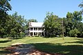 Perdue-Williams Estes House, completed c. 1895


Furman, Alabama | |
|---|---|
Unincorporated community | |
 Furman, Alabama Location within the state of Alabama  Furman, Alabama Furman, Alabama (the United States) | |
| Coordinates: 32°0′24.53″N 86°58′0.94″W | |
| Country | United States |
| State | Alabama |
| County | Wilcox |
| Elevation | 292 ft (89 m) |
| Time zone | UTC-6 (Central (CST)) |
| • Summer (DST) | UTC-5 (CDT) |
| Area code | 334 |
Demographics
| Historical population | |||
|---|---|---|---|
| Census | Pop. | %± | |
| 1890 | 195 | — | |
| 1900 | 184 | −5.6% | |
| 1910 | 125 | −32.1% | |
| 1920 | 190 | 52.0% | |
| 1930 | 229 | 20.5% | |
| U.S. Decennial Census[3] | |||
Furman was listed as an incorporated community from 1890 to 1930 on the U.S. Census rolls. It either disincorporated or lost its charter after 1930.
Geography
Furman is located at 32.00681°N 86.96692°W and has an elevation of 292 feet (89 m).[1]
References
Wikimedia Commons has media related to Furman, Alabama.
- U.S. Geological Survey Geographic Names Information System: Furman, Alabama
- "National Register Information System". National Register of Historic Places. National Park Service. April 15, 2008.
- "U.S. Decennial Census". Census.gov. Archived from the original on May 7, 2015. Retrieved June 6, 2013.
Municipalities and communities of Wilcox County, Alabama, United States | ||
|---|---|---|
County seat: Camden | ||
| City | 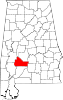 | |
| Towns | ||
| CDPs | ||
| Unincorporated communities | ||
| Ghost towns | ||
| ||
This Wilcox County, Alabama state location article is a stub. You can help Wikipedia by expanding it. |
Текст в блоке "Читать" взят с сайта "Википедия" и доступен по лицензии Creative Commons Attribution-ShareAlike; в отдельных случаях могут действовать дополнительные условия.
Другой контент может иметь иную лицензию. Перед использованием материалов сайта WikiSort.org внимательно изучите правила лицензирования конкретных элементов наполнения сайта.
Другой контент может иметь иную лицензию. Перед использованием материалов сайта WikiSort.org внимательно изучите правила лицензирования конкретных элементов наполнения сайта.
2019-2026
WikiSort.org - проект по пересортировке и дополнению контента Википедии
WikiSort.org - проект по пересортировке и дополнению контента Википедии