world.wikisort.org - USA
Eagle Butte is a city in Dewey and Ziebach counties in South Dakota, United States. The population was 1,258 at the 2020 census.[6]
Eagle Butte, South Dakota | |
|---|---|
City | |
 Location in Dewey County and the state of South Dakota | |
| Coordinates: 44°59′47″N 101°14′9″W | |
| Country | United States |
| State | South Dakota |
| Counties | Dewey, Ziebach |
| Incorporated | 1911[1] |
| Area | |
| • Total | 1.47 sq mi (3.80 km2) |
| • Land | 1.36 sq mi (3.53 km2) |
| • Water | 0.10 sq mi (0.27 km2) |
| Elevation | 2,418 ft (737 m) |
| Population (2020)[3] | |
| • Total | 1,258 |
| • Density | 923.64/sq mi (356.73/km2) |
| Time zone | UTC−7 (Mountain (MST)) |
| • Summer (DST) | UTC−6 (MDT) |
| ZIP code | 57625 |
| Area code | 605 |
| FIPS code | 46-17620[4] |
| GNIS feature ID | 1267668[5] |
Description
Eagle Butte is the tribal headquarters of the Cheyenne River Sioux Tribe on the Cheyenne River Indian Reservation.[7]
The city takes its name from Eagle Butte.[8]
Geography
Eagle Butte is located at 44°59′47″N 101°14′9″W (44.996502, -101.235875).[9]
According to the United States Census Bureau, the city has a total area of 1.17 square miles (3.03 km2), all land.[10]
Eagle Butte has been assigned the ZIP code 57625 and the FIPS place code 17620.
Demographics
| Historical population | |||
|---|---|---|---|
| Census | Pop. | %± | |
| 1920 | 210 | — | |
| 1930 | 387 | 84.3% | |
| 1940 | 374 | −3.4% | |
| 1950 | 375 | 0.3% | |
| 1960 | 495 | 32.0% | |
| 1970 | 530 | 7.1% | |
| 1980 | 435 | −17.9% | |
| 1990 | 489 | 12.4% | |
| 2000 | 619 | 26.6% | |
| 2010 | 1,318 | 112.9% | |
| 2020 | 1,258 | −4.6% | |
| U.S. Decennial Census[11][3] | |||
2010 census
As of the census[12] of 2010, there were 1,318 people, 384 households, and 279 families living in the city. The population density was 1,126.5 inhabitants per square mile (434.9/km2). There were 414 housing units at an average density of 353.8 per square mile (136.6/km2). The racial makeup of the city was 6.8% White, 0.3% African American, 89.2% Native American, 0.2% Asian, 0.2% from other races, and 3.3% from two or more races. Hispanic or Latino of any race were 4.3% of the population.
There were 384 households, of which 59.6% had children under the age of 18 living with them, 19.3% were married couples living together, 44.5% had a female householder with no husband present, 8.9% had a male householder with no wife present, and 27.3% were non-families. 24.2% of all households were made up of individuals, and 7.8% had someone living alone who was 65 years of age or older. The average household size was 3.43 and the average family size was 3.90.
The median age in the city was 22.8 years. 41.3% of residents were under the age of 18; 12.1% were between the ages of 18 and 24; 25.5% were from 25 to 44; 16.1% were from 45 to 64; and 4.9% were 65 years of age or older. The gender makeup of the city was 47.3% male and 52.7% female.
2000 census
As of the census[4] of 2000, there were 619 people, 227 households, and 140 families living in the city. The population density was 675.4 people per square mile (259.8/km2). There were 262 housing units at an average density of 285.9 per square mile (110.0/km2). The racial makeup of the city was 18.26% White, 80.29% Native American, and 1.45% from two or more races. Hispanic or Latino of any race were 1.29% of the population.
There were 227 households, out of which 43.2% had children under the age of 18 living with them, 29.1% were married couples living together, 26.9% had a female householder with no husband present, and 37.9% were non-families. 33.5% of all households were made up of individuals, and 12.3% had someone living alone who was 65 years of age or older. The average household size was 2.72 and the average family size was 3.49.
In the city, the population was spread out, with 38.8% under the age of 18, 12.8% from 18 to 24, 25.8% from 25 to 44, 14.1% from 45 to 64, and 8.6% who were 65 years of age or older. The median age was 24 years. For every 100 females, there were 93.4 males. For every 100 females age 18 and over, there were 77.1 males.
As of 2000 the median income for a household in the city was $18,611, and the median income for a family was $20,313. Males had a median income of $23,125 versus $24,167 for females. The per capita income for the city was $9,192. About 41.6% of families and 47.9% of the population were below the poverty line, including 58.9% of those under age 18 and 21.6% of those age 65 or over.
Education
It is in the Eagle Butte School District,[13] which jointly operates Cheyenne-Eagle Butte School with the Bureau of Indian Education (BIE).[14]
Until 2014 there was also a branch of Presentation College located in the town.[15]
Notable people
- Norm Van Brocklin - Pro Football Hall of Fame player and coach.[16]
- Joshua Prager - Author and Journalist [17]
- Earl Rose - Dallas County medical examiner at the time of the Kennedy Assassination.[18]
See also
- List of cities in South Dakota
References
- "SD Towns" (PDF). South Dakota State Historical Society. Archived from the original (PDF) on 2010-02-10. Retrieved 2010-02-11.
- "ArcGIS REST Services Directory". United States Census Bureau. Retrieved October 15, 2022.
- "Census Population API". United States Census Bureau. Retrieved Oct 15, 2022.
- "U.S. Census website". United States Census Bureau. Retrieved 2008-01-31.
- U.S. Geological Survey Geographic Names Information System: Eagle Butte
- "U.S. Census Bureau: Eagle Butte city, South Dakota". www.census.gov. United States Census Bureau. Retrieved 13 February 2022.
- South Dakota Office of Tribal Government Relations Archived 2009-02-08 at the Wayback Machine Retrieved on 2009-02-08.
- Federal Writers' Project (1940). South Dakota place-names, v.1-3. University of South Dakota. p. 36.
- "US Gazetteer files: 2010, 2000, and 1990". United States Census Bureau. 2011-02-12. Retrieved 2011-04-23.
- "US Gazetteer files 2010". United States Census Bureau. Archived from the original on 2012-07-02. Retrieved 2012-06-21.
- United States Census Bureau. "Census of Population and Housing". Retrieved July 15, 2014.
- "U.S. Census website". United States Census Bureau. Retrieved 2012-06-21.
- "2020 CENSUS - SCHOOL DISTRICT REFERENCE MAP: Dewey County, SD" (PDF). U.S. Census Bureau. Retrieved 2021-08-06.
- "About". Eagle Butte School District 20-1. Retrieved 2021-08-06.
- "Eagle-Butte - Presentation College". Archived from the original on 2 April 2016. Retrieved 18 April 2016.
- Dart, Bob. "Squaring off in South Dakota." Austin American-Statesman. October 22, 2004. Retrieved on October 18, 2009.
- Official Website - "Josh was born in Eagle Butte, South Dakota. He grew up in New Jersey and lives in New York."
- Martin, Douglas (May 2, 2012). "Earl Rose, Coroner When Kennedy Was Shot, Dies at 85". The New York Times. New York. Retrieved April 1, 2013.
External links
- Eagle Butte at Curlie
Municipalities and communities of Dewey County, South Dakota, United States | ||
|---|---|---|
County seat: Timber Lake | ||
| Cities | 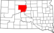 | |
| Town | ||
| CDPs | ||
| Other communities | ||
| Indian reservations |
| |
| Footnotes | ‡This populated place also has portions in an adjacent county or counties | |
| ||
Municipalities and communities of Ziebach County, South Dakota, United States | ||
|---|---|---|
County seat: Dupree | ||
| Cities |  | |
| Unorganized territories |
| |
| CDPs | ||
| Other communities |
| |
| Indian reservations |
| |
| Footnotes | ‡This populated place also has portions in an adjacent county or counties | |
| ||
Authority control | |
|---|---|
| General |
|
| National libraries | |
Другой контент может иметь иную лицензию. Перед использованием материалов сайта WikiSort.org внимательно изучите правила лицензирования конкретных элементов наполнения сайта.
WikiSort.org - проект по пересортировке и дополнению контента Википедии