world.wikisort.org - USA
Collier County is a county in the U.S. state of Florida. As of the 2020 census, the population was 375,752; an increase of 16.9% since the 2010 United States Census.[1] Its county seat is East Naples,[2] where the county offices were moved from Everglades City in 1962.
Collier County | |
|---|---|
U.S. county | |
 The Collier County courthouse in April 2010 | |
 Flag  Seal | |
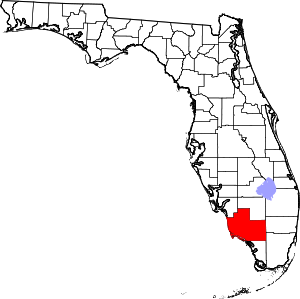 Location within the U.S. state of Florida | |
 Florida's location within the U.S. | |
| Coordinates: 26°05′N 81°24′W | |
| Country | |
| State | |
| Founded | May 8, 1923 |
| Named for | Barron Collier |
| Seat | East Naples |
| Largest city | Naples |
| Area | |
| • Total | 2,305 sq mi (5,970 km2) |
| • Land | 1,998 sq mi (5,170 km2) |
| • Water | 307 sq mi (800 km2) 13.3%% |
| Population (2020) | |
| • Total | 375,752 |
| • Density | 188/sq mi (73/km2) |
| Time zone | UTC−5 (Eastern) |
| • Summer (DST) | UTC−4 (EDT) |
| Congressional districts | 19th, 25th |
| Website | www |

Collier County comprises the Naples-Immokalee-Marco Island Metropolitan Statistical Area, which is included in the Cape Coral-Fort Myers-Naples Combined Statistical Area.
History
Archaeology at Platt Island in the Big Cypress National Preserve shows humans settled in what is now Collier County more than two thousand years ago.[3] The Calusa people had an extensive presence in the area when Europeans arrived.
The county was created in 1923 from Lee County. It was named for Barron Collier, a New York City advertising mogul and real estate developer who had moved to Southwest Florida and established himself as a prominent landowner. He agreed to build the Tamiami Trail for what was then Lee County (comprising today's Collier, Hendry, and Lee Counties) in exchange for favorable consideration with the state legislature to have a county named for him. After Collier County was named, Collier was quoted as saying: "When I first came here on holiday with Juliet, I never expected that I would buy a whole region of it, nor did I expect to pay for the new Tamiami Trail, or half the things I've done. But I really didn't expect to have a whole county named after me."[4]
Geography
According to the U.S. Census Bureau, the county has a total area of 2,305 square miles (5,970 km2), of which 1,998 square miles (5,170 km2) is land and 307 square miles (800 km2) (13.3%) is water.[5] It is the largest county in Florida by land area and fourth-largest by total area. Virtually the entire southeastern portion of the county lies within the Big Cypress National Preserve. The northernmost portion of Everglades National Park extends into the southern coastal part of the county. The total area of this county is nearly 1.5 times the size of Rhode Island, which is the smallest state, and is bigger than Rhode Island and Luxembourg combined.
Adjacent counties
Collier County is located at the southern end of Florida's Gulf Coast, and bounded by:
- Hendry County - north
- Broward County - east
- Miami-Dade County - southeast
- Monroe County - south
- Lee County - northwest
National protected areas
- Big Cypress National Preserve (part)
- Everglades National Park (part)
- Florida Panther National Wildlife Refuge
- Ten Thousand Islands National Wildlife Refuge
Transportation
- Everglades Airpark
- Immokalee Airport
- Marco Island Airport
- Naples Municipal Airport
- Dade-Collier Training and Transition Airport (mostly unused)
Major highways
 Interstate 75
 U.S. Route 41
 State Road 29
 State Road 84
 State Road 951
Demographics
| Historical population | |||
|---|---|---|---|
| Census | Pop. | %± | |
| 1930 | 2,883 | — | |
| 1940 | 5,102 | 77.0% | |
| 1950 | 6,488 | 27.2% | |
| 1960 | 15,753 | 142.8% | |
| 1970 | 38,040 | 141.5% | |
| 1980 | 85,971 | 126.0% | |
| 1990 | 152,099 | 76.9% | |
| 2000 | 251,377 | 65.3% | |
| 2010 | 321,520 | 27.9% | |
| 2020 | 375,752 | 16.9% | |
| U.S. Decennial Census[6] 1790-1960[7] 1900-1990[8] 1990-2000[9] 2010-2015[10] 2020[11] | |||
2000 census
As of the census[12] of 2000, there were 251,377 people, 102,973 households, and 71,257 families residing in the county. The population density was 124 people per square mile (48/km2). There were 144,536 housing units at an average density of 71 per square mile (28/km2).
As of 2000[update], 86.06% of the population was White, 4.54% was Black or African American, 0.29% Native American, 0.62% Asian, 0.06% Pacific Islander, 6.19% from other races, and 2.23% from two or more races. Hispanic or Latino individuals (of any race) accounted for 19.61%. Languages spoken: 75.3% spoke English, 17.8% Spanish, 2.3% French Creole and 1.2% German as their first language.
In 2000 there were 102,973 households, out of which 22.70% had children under the age of 18 living with them, 58.10% were married couples living together, 7.20% had a female householder with no husband present, and 30.80% were non-families. 24.50% of all households were made up of individuals, and 11.90% had someone living alone who was 65 years of age or older. The average household size was 2.39 and the average family size was 2.79.
The county's population distribution by age was spread out but older than the U.S. as a whole, with 19.90% under the age of 18, 6.60% from 18 to 24, 24.60% from 25 to 44, 24.50% from 45 to 64, and 24.50% who were 65 years of age or older. The median age was 44.1 years. For every 100 females there were 100.30 males. For every 100 females age 18 and over, there were 99.20 males.
The median income for a household in the county was $48,289, and the median income for a family was $54,816. Males had a median income of $32,639 versus $26,371 for females. The per capita income for the county was $31,195. About 6.60% of families and 10.30% of the population were below the poverty line, including 16.20% of those under age 18 and 4.30% of those age 65 or over.
2010 census
The county continues to experience significant growth and is becoming increasingly diverse. As of the 2010 census, the county's population had increased to 321,520, an increase of 27.9% over the 2000 census. As of 2012[update], the United States Census estimates the county's population at 332,427, an increase of 3.4% since the 2010 census. As of the 2010 census, 83.85% of the population was non-Hispanic whites, 25.9% was Latino or Hispanic, 6.6% was African-American and 1.1% was Asian.[13] As of the 2010 census, the greatest source of population growth in the county since the 2000 census came from the Latino or Hispanic population which grew from 49,296 (19.6% of the total population) to 83,177 (25.9% of the total population). In terms of ancestry, 37.9% were English, 9.9% were Irish, 9.1% were "American", 3.2% were Italian and 3.1% were German.[14]
2020 census
| Race | Pop 2010 | Pop 2020 | % 2010 | % 2020 |
|---|---|---|---|---|
| White (NH) | 211,156 | 235,455 | 65.67% | 62.66% |
| Black or African American (NH) | 19,898 | 22,554 | 6.19% | 6.0% |
| Native American or Alaska Native (NH) | 609 | 551 | 0.19% | 0.15% |
| Asian (NH) | 3,390 | 5,419 | 1.05% | 1.44% |
| Pacific Islander (NH) | 72 | 61 | 0.02% | 0.02% |
| Some Other Race (NH) | 431 | 1,502 | 0.13% | 0.4% |
| Mixed/Multi-Racial (NH) | 2,787 | 7,961 | 0.87% | 2.12% |
| Hispanic or Latino | 83,177 | 102,249 | 25.87% | 27.21% |
| Total | 321,520 | 375,752 |
As of the 2020 United States census, there were 375,752 people, 140,578 households, and 97,279 families residing in the county.
Education
The county's public schools are operated by the District School Board of Collier County.
Public library
The Collier County Public Library system consists of ten locations servicing the entire county. All locations offer public internet stations, printing, photocopying, free Wi-Fi, and 24/7 dropboxes for book and video returns.[17]
Politics
Voter registration
According to the Secretary of State's office, Republicans compose a majority of registered voters in Collier County. It is also one of the handful of counties where independents outnumber Democrats among registrants. The county is part of a long-established Republican stronghold in southwestern coastal Florida: the last Democrat to win the county being Adlai Stevenson II in 1952.[18] The last Democratic Governor to carry the county was Reubin Askew in 1974 and the last Democratic Senator to do so was Bob Graham in 1992, six years later the county was one of four to back the Republican candidate, Charlie Crist.
All voter information is as of June 22, 2018[update], and provided by Collier County Supervisor of Elections Office:[19]
Statewide elections
| Year | Republican | Democratic | Third party | |||
|---|---|---|---|---|---|---|
| No. | % | No. | % | No. | % | |
| 2020 | 128,950 | 61.91% | 77,621 | 37.27% | 1,714 | 0.82% |
| 2016 | 105,423 | 61.11% | 61,085 | 35.41% | 6,002 | 3.48% |
| 2012 | 96,520 | 64.64% | 51,698 | 34.62% | 1,106 | 0.74% |
| 2008 | 86,379 | 60.84% | 54,450 | 38.35% | 1,159 | 0.82% |
| 2004 | 83,631 | 64.99% | 43,892 | 34.11% | 1,160 | 0.90% |
| 2000 | 60,467 | 65.58% | 29,939 | 32.47% | 1,796 | 1.95% |
| 1996 | 42,593 | 58.74% | 23,185 | 31.97% | 6,739 | 9.29% |
| 1992 | 38,448 | 53.44% | 18,796 | 26.13% | 14,700 | 20.43% |
| 1988 | 38,920 | 74.87% | 12,769 | 24.57% | 291 | 0.56% |
| 1984 | 33,619 | 78.75% | 9,067 | 21.24% | 5 | 0.01% |
| 1980 | 23,900 | 71.10% | 7,739 | 23.02% | 1,974 | 5.87% |
| 1976 | 14,643 | 61.76% | 8,764 | 36.96% | 303 | 1.28% |
| 1972 | 13,501 | 80.63% | 3,201 | 19.12% | 42 | 0.25% |
| 1968 | 5,362 | 50.85% | 2,230 | 21.15% | 2,952 | 28.00% |
| 1964 | 3,581 | 55.45% | 2,877 | 44.55% | 0 | 0.00% |
| 1960 | 2,708 | 60.74% | 1,750 | 39.26% | 0 | 0.00% |
| 1956 | 1,934 | 59.73% | 1,304 | 40.27% | 0 | 0.00% |
| 1952 | 1,086 | 49.59% | 1,104 | 50.41% | 0 | 0.00% |
| 1948 | 247 | 28.07% | 362 | 41.14% | 271 | 30.80% |
| 1944 | 180 | 21.95% | 640 | 78.05% | 0 | 0.00% |
| 1940 | 156 | 16.17% | 809 | 83.83% | 0 | 0.00% |
| 1936 | 88 | 8.89% | 902 | 91.11% | 0 | 0.00% |
| 1932 | 37 | 8.03% | 424 | 91.97% | 0 | 0.00% |
| 1928 | 151 | 37.01% | 256 | 62.75% | 1 | 0.25% |
| 1924 | 15 | 8.33% | 148 | 82.22% | 17 | 9.44% |
| Year | Republican | Democratic | Third parties |
|---|---|---|---|
| 2018 | 64.52% 100,303 | 34.48% 53,594 | 1.00% 1,556 |
| 2014 | 66.31% 75,337 | 31.05% 35,281 | 2.64% 3,002 |
| 2010 | 65.12% 66,960 | 32.49% 33,408 | 2.39% 2,465 |
| 2006 | 68.80% 59,821 | 29.10% 25,303 | 2.10% 1,822 |
| 2002 | 73.74% 61,555 | 25.44% 21,237 | 0.82% 687 |
| 1998 | 71.06% 41,688 | 28.94% 16,981 | 0.00% 1 |
| 1994 | 61.40% 36,370 | 38.60% 22,860 |
Communities
Cities
Census-designated places
Other unincorporated communities
- Carnestown
- Copeland
- East Naples
- Isles of Capri
- Jerome
- Miles City
- North Naples
- Ochopee
- Vanderbilt Beach
- Vanderbilt Beach Estates
Invasive snake issues

Collier is located in the center of Florida's invasive snake epidemic. A three-month effort at the beginning of 2016 netted over one ton of captured snakes, including a Florida record for largest male Burmese python, measuring 16 feet and weighing 140 pounds.[21][22][23]
See also
- Keewaydin Club
- National Register of Historic Places listings in Collier County, Florida
- Old Collier County Courthouse
References
- "Collier County, Florida Demographics and Housing 2020 Decennial Census".
- "Find a County". National Association of Counties. Archived from the original on May 31, 2011. Retrieved June 7, 2011.
- Widmer, Randolph J. (1988). "The Prehistory of Southwest Florida". Evolution of the Calusa: a Stratified Non-Agricultural Chiefdom on the Southwest Florida Coast. University of Alabama Press. p. 72. ISBN 9780817303587.
- Clark, James C. (2014). A Concise History of Florida. Arcadia. p. 150. ISBN 9781625851536.
- "US Gazetteer files: 2010, 2000, and 1990". United States Census Bureau. February 12, 2011. Retrieved April 23, 2011.
- "U.S. Decennial Census". United States Census Bureau. Retrieved June 13, 2014.
- "Historical Census Browser". University of Virginia Library. Retrieved June 13, 2014.
- "Population of Counties by Decennial Census: 1900 to 1990". United States Census Bureau. Retrieved June 13, 2014.
- "Census 2000 PHC-T-4. Ranking Tables for Counties: 1990 and 2000" (PDF). United States Census Bureau. Retrieved June 13, 2014.
- "State & County QuickFacts". United States Census Bureau. Archived from the original on August 7, 2011. Retrieved February 12, 2014.
- "Collier County, Florida Demographics and Housing 2020 Decennial Census".
- "U.S. Census website". United States Census Bureau. Retrieved May 14, 2011.
- "Collier County Census Overview". colliercountyfl.gov.
- "POPULATION & DEMOGRAPHICS | Collier County, FL". www.colliercountyfl.gov.
- "Explore Census Data". data.census.gov. Retrieved February 12, 2022.
- "Explore Census Data". data.census.gov. Retrieved February 12, 2022.
- "Locations, hours, maps". Collier County Public Library. Retrieved April 22, 2016.
- Sullivan, Robert David; ‘How the Red and Blue Map Evolved Over the Past Century’; America Magazine in The National Catholic Review; June 29, 2016
- "Collier County Supervisor of Elections". Retrieved June 22, 2018.
- Leip, David. "Dave Leip's Atlas of U.S. Presidential Elections". uselectionatlas.org.
- "A ton of Burmese pythons removed in 90 days". March 17, 2016.
- "South Florida has pythons by the ton, literally".
- "South Florida has pythons by the ton, literally".
External links
Government links/Constitutional offices
- Collier County official website / Board of County Commissioners official website
- Collier County Supervisor of Elections
- Collier County Property Appraiser
- Collier County Sheriff's Office
- Collier County Tax Collector
- Collier County Public Library
Special districts
Judicial branch
- Collier County Clerk of Courts
- Public Defender, 20th Judicial Circuit serving Charlotte, Collier, Glades, Hendry and Lee Counties
- Office of the State Attorney, 20th Judicial Circuit Archived December 10, 2004, at the Wayback Machine
- Circuit and County Court for the 20th Judicial Circuit of Florida
Recycling Center
Tourism links
Places adjacent to Collier County, Florida | ||||||||||||||||
|---|---|---|---|---|---|---|---|---|---|---|---|---|---|---|---|---|
| ||||||||||||||||
Municipalities and communities of Collier County, Florida, United States | ||
|---|---|---|
County seat: East Naples | ||
| Cities |  | |
| CDPs | ||
| Unincorporated communities |
| |
| Ghost towns | ||
| ||
State of Florida | |
|---|---|
Tallahassee (capital) | |
| Topics |
|
| History |
|
| Geography | |
| Major hurricanes |
|
| Society |
|
| Regions |
|
| Metro areas |
|
| Largest cities | |
| Counties |
|
Authority control | |
|---|---|
| General | |
| National libraries | |
На других языках
[de] Collier County
Das Collier County[1] ist ein County im US-Bundesstaat Florida. Der Verwaltungssitz (County Seat) ist Naples.- [en] Collier County, Florida
[ru] Коллиер (округ)
Ко́ллиер[1] (англ. Collier county) — округ штата Флорида Соединённых Штатов Америки. На 2000 год в нём проживало 251 377 человек. По оценке бюро переписи населения США в 2007 году население округа составляло 315 839 человек.[2]Другой контент может иметь иную лицензию. Перед использованием материалов сайта WikiSort.org внимательно изучите правила лицензирования конкретных элементов наполнения сайта.
WikiSort.org - проект по пересортировке и дополнению контента Википедии