world.wikisort.org - USA
Bellevue (French for "beautiful view"; previously named Belleview[3]) is a suburban city in Sarpy County, Nebraska, United States. It is part of the Omaha–Council Bluffs metropolitan area, and had a population of 64,176 as of the 2020 Census, making it the third-largest city in Nebraska, behind Omaha and Lincoln, and the second largest city in the U.S. named "Bellevue," behind Bellevue, Washington.
Bellevue, Nebraska | |
|---|---|
City | |
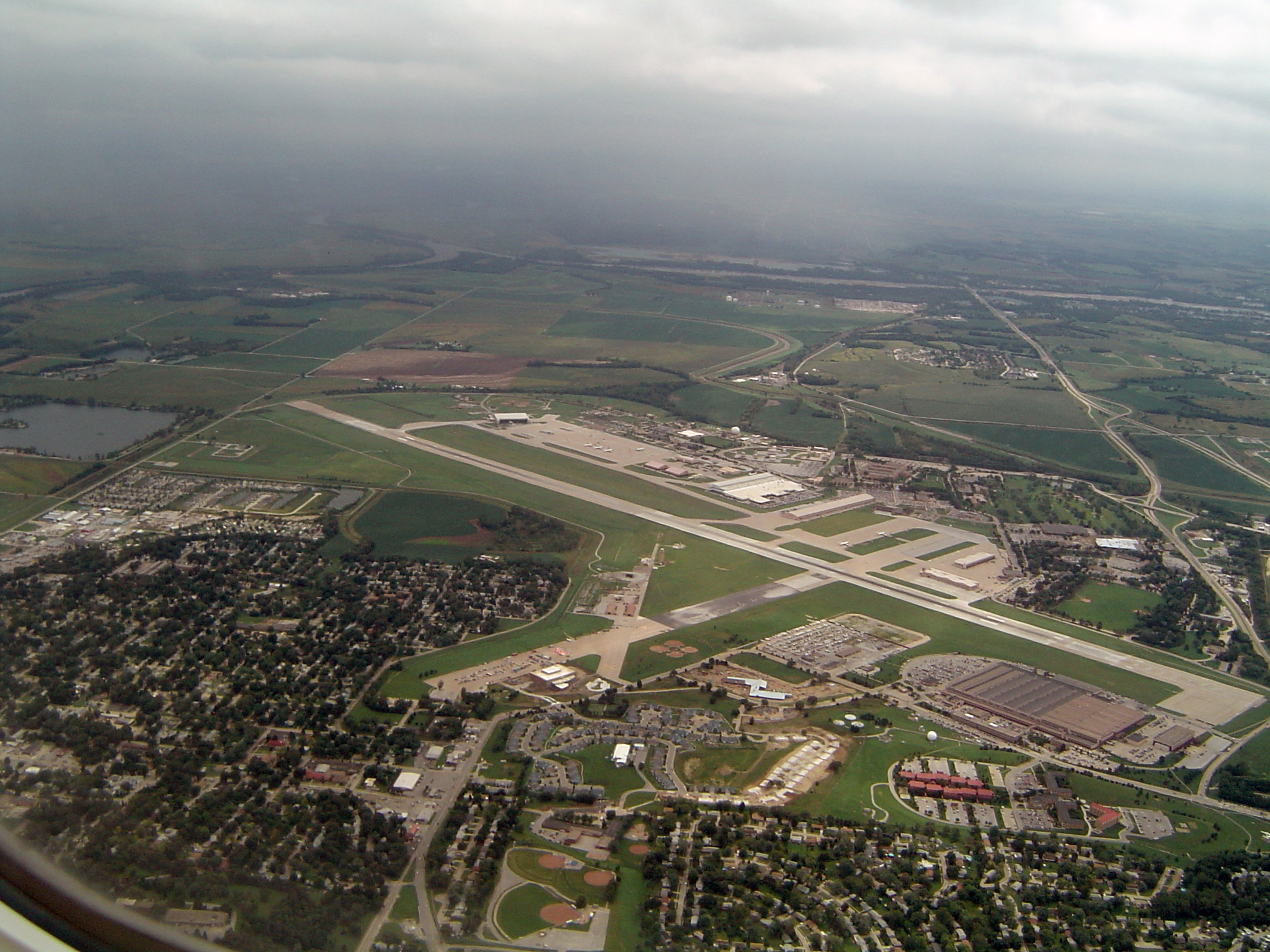 Aerial view of Offutt Air Force Base with Bellevue in foreground | |
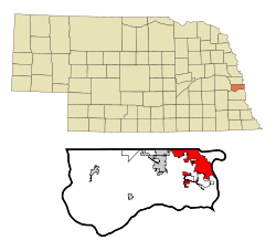 Location of Bellevue within Nebraska and Sarpy County | |
| Coordinates: 41°9′31″N 95°56′3″W | |
| Country | United States |
| State | Nebraska |
| County | Sarpy |
| Area | |
| • Total | 21.71 sq mi (56.24 km2) |
| • Land | 21.49 sq mi (55.65 km2) |
| • Water | 0.23 sq mi (0.59 km2) |
| Elevation | 1,033 ft (315 m) |
| Population (2020) | |
| • Total | 64,176 |
| • Density | 2,986.74/sq mi (1,153.17/km2) |
| Time zone | UTC−6 (Central (CST)) |
| • Summer (DST) | UTC−5 (CDT) |
| Area code | 402/531 |
| FIPS code | 31-03950 |
| GNIS feature ID | 0827304[2] |
| Website | http://www.bellevue.net/ |
Originally settled by European Americans in the 1830s, Bellevue was incorporated in 1855 and is the oldest continuous town in Nebraska. It has been credited by the Nebraska State Legislature as being the state's second-oldest settlement; previously it served as the seat of government in Nebraska.[4]
Geography
Bellevue is located at an elevation of 1159 ft (353 m). According to the United States Census Bureau, the city has a total area of 16.02 square miles (41.49 km2), of which 15.85 square miles (41.05 km2) is land and 0.17 square miles (0.44 km2) is water.[5] It is bounded on the east by the Missouri River.
History
Bellevue was originally founded as a trading post for the Missouri Fur Company by Joshua Pilcher, but there were financial problems, and, eventually, Lucien Fontanelle became the owner of the post, and the first permanent resident of Bellevue. Moses Merrill founded a mission, which was the first Christian mission in Nebraska, in Bellevue.[6] Since it was the oldest city in the Nebraska Territory, the residents were optimistic that Bellevue would become the capital of it, and the new territorial governor, Francis Burt, had already moved there, but shortly after, he died. The next governor selected Omaha as the capital instead. In 1921, the Offutt Air Force Base, housing the United States Strategic Command, was built south of Bellevue. The planes that dropped the Hiroshima and Nagasaki atomic bombs were built there.[7][8]
Demographics
| Historical population | |||
|---|---|---|---|
| Census | Pop. | %± | |
| 1880 | 211 | — | |
| 1890 | 754 | 257.3% | |
| 1900 | 527 | −30.1% | |
| 1910 | 596 | 13.1% | |
| 1920 | 695 | 16.6% | |
| 1930 | 1,017 | 46.3% | |
| 1940 | 1,184 | 16.4% | |
| 1950 | 3,858 | 225.8% | |
| 1960 | 8,831 | 128.9% | |
| 1970 | 21,953 | 148.6% | |
| 1980 | 21,813 | −0.6% | |
| 1990 | 39,240 | 79.9% | |
| 2000 | 44,382 | 13.1% | |
| 2010 | 50,137 | 13.0% | |
| 2020 | 64,176 | 28.0% | |
| U.S. Decennial Census[9] 2018 Estimate[10] | |||
2010 census
At the 2010 census there were 50,137 people, 19,142 households, and 13,371 families living in the city. The population density was 3,163.2 inhabitants per square mile (1,221.3/km2). There were 20,591 housing units at an average density of 1,299.1 per square mile (501.6/km2). The racial makeup of the city was 81.5% White, 6.0% African American, 0.7% Native American, 2.3% Asian, 0.2% Pacific Islander, 5.4% from other races, and 3.9% from two or more races. Hispanic or Latino of any race were 11.9%.[11]
Of the 19,142 households 36.1% had children under the age of 18 living with them, 51.9% were married couples living together, 13.0% had a female householder with no husband present, 5.0% had a male householder with no wife present, and 30.1% were non-families. 24.3% of households were one person and 7.9% were one person aged 65 or older. The average household size was 2.62 and the average family size was 3.11.
The median age was 34.8 years. 26.4% of residents were under the age of 18; 9.8% were between the ages of 18 and 24; 26.7% were from 25 to 44; 25.6% were from 45 to 64; and 11.5% were 65 or older. The gender makeup of the city was 49.2% male and 50.8% female.
2000 census
At the 2000 census, there were 44,382 people, 16,937 households, and 11,940 families living in the city. The population density was 3,346.4 people per square mile (1,292.3/km2). There were 17,439 housing units at an average density of 1,314.9 per square mile (507.8/km2). The racial makeup of the city was 85.83% White, 6.13% African American, 0.50% Native American, 2.11% Asian, 0.11% Pacific Islander, 2.78% from other races, and 2.54% from two or more races. Hispanic or Latino of any race were 5.88% of the population.
Of the 16,937 households 35.5% had children under the age of 18 living with them, 55.4% were married couples living together, 11.3% had a female householder with no husband present, and 29.5% were non-families. 23.2% of households were one person and 6.6% were one person aged 65 or older. The average household size was 2.61 and the average family size was 3.09.
The age distribution was 27.4% under the age of 18, 10.2% from 18 to 24, 31.0% from 25 to 44, 21.8% from 45 to 64, and 9.6% 65 or older. The median age was 34 years. For every 100 females, there were 98.3 males. For every 100 females age 18 and over, there were 95.6 males.
The median household income was $47,201 and the median family income was $54,422. Males had a median income of $33,819 versus $25,783 for females. The per capita income for the city was $20,903. About 4.1% of families and 5.9% of the population were below the poverty line, including 7.9% of those under age 18 and 3.8% of those age 65 or over.
Notable people
- Buddy Carlyle, Major League Baseball pitcher and coach
- Henry T. Clarke Sr., merchant and legislator, father of Henry Clarke
- Henry Clarke, legislator and baseball player
- Tyler Cloyd, baseball pitcher
- Abbie Cornett, Nebraska state legislator
- William Forsee, Presidential elector
- Bob Gibson, baseball player and hall of famer
- Leisha Hailey, actress, musician
- Robert Hays, actor known for his film role as pilot Ted Striker in the movie Airplane!
- Manny Lawson, football player
- Thakoon Panichgul, Thai-American Fashion Designer
- Todd Pratt, Former New York Mets baseball catcher.
- Don Preister, Nebraska State Senator
- Terry D. Scott, tenth Master Chief Petty Officer of the Navy (MCPON)
- Molly Schuyler, competitive eating champion
- Yvonne Turner, WNBA Basketball Player
- Regis F. A. Urschler, USAF Brigadier General and P-51 air show pilot
See also
- Bellevue Public Schools
- Great Plains Art Museum
- Moses Merill Mission
- Offutt Air Force Base
- United States Strategic Command
- Sarpy County Historical Museum
- Nebraska Medicine- Bellevue
References
- "ArcGIS REST Services Directory". United States Census Bureau. Retrieved September 18, 2022.
- "US Board on Geographic Names". United States Geological Survey. 2007-10-25. Retrieved 2008-01-31.
- "Selected Poetry". D.E. Reed & Co. Nebraska Palladium. January 24, 1855.
- (1912) Bulletin. Issues 2. Nebraska State Legislature. p. 7.
- "US Gazetteer files 2010". United States Census Bureau. Archived from the original on 2012-01-25. Retrieved 2012-06-24.
- team, The Explore Nebraska History. "Oto Mission". Explore Nebraska History. Retrieved 2021-09-23.
- "Bellevue: The First Twenty Years". History Nebraska. Retrieved 2021-09-23.
- "City of Bellevue Nebraska > Information > History of Bellevue". www.bellevue.net. Retrieved 2021-09-23.
- "U.S. Decennial Census". Census.gov. Retrieved April 19, 2013.
- "Population Estimates". United States Census Bureau. Retrieved June 8, 2018.
- "U.S. Census website". United States Census Bureau. Retrieved 2012-06-24.
External links
Municipalities and communities of Sarpy County, Nebraska, United States | ||
|---|---|---|
County seat: Papillion | ||
| Cities |  | |
| CDPs |
| |
| Other communities | ||
| ||
State of Nebraska | |
|---|---|
Lincoln (capital) | |
| Topics |
|
| Society |
|
| Regions |
|
| Largest cities |
|
| Counties |
|
Metropolitan area of Omaha–Council Bluffs | ||||||
|---|---|---|---|---|---|---|
| Primary cities |
|  | ||||
| Cities over 10,000 (per 2010 Census) |
| |||||
| Cities of 5,000 to 10,000 (per 2010 Census) |
| |||||
| Cities of 1,000 to 5,000 (per 2010 Census) |
| |||||
| Census-designated places |
| |||||
| Cities and villages of fewer than 1,000 (per 2010 Census) |
| |||||
| Counties |
| |||||
Authority control | |
|---|---|
| General | |
| National libraries | |
| Other |
|
На других языках
[de] Bellevue (Nebraska)
Bellevue liegt im US-Bundesstaat Nebraska im Sarpy County. Es ist die älteste und drittgrößte Stadt des gesamten Staates.- [en] Bellevue, Nebraska
[ru] Белвью (Небраска)
Белвью[источник не указан 1998 дней], Белвю[1] (англ. Bellevue) — город, расположенный в округе Сарпи (штат Небраска, США) с населением в 50 137 человек по статистическим данным переписи 2010 года. Название происходит от французских слов, означающих «прекрасный вид». Белвью был основан в 1830 году и являлся первой столицей штата.Другой контент может иметь иную лицензию. Перед использованием материалов сайта WikiSort.org внимательно изучите правила лицензирования конкретных элементов наполнения сайта.
WikiSort.org - проект по пересортировке и дополнению контента Википедии