world.wikisort.org - USA
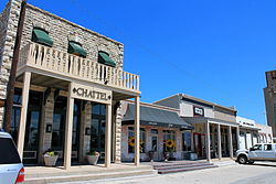
Aledo (/əˈliːdoʊ/ ə-LEE-doh) is a city in Parker County, Texas, United States.[2] The population was 4,858 in 2020.[5]
Aledo, Texas | |
|---|---|
City | |
 | |
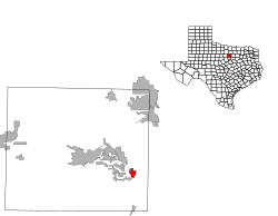
 Location of Aledo, Texas | |
 | |
| Coordinates: 32°41′44″N 97°36′12″W | |
| Country | United States |
| State | Texas |
| County | Parker |
| Area | |
| • Total | 2.62 sq mi (6.80 km2) |
| • Land | 2.62 sq mi (6.80 km2) |
| • Water | 0.00 sq mi (0.00 km2) |
| Elevation | 883 ft (269 m) |
| Population (2010) | |
| • Total | 2,716 |
| • Estimate (2019)[3] | 4,985 |
| • Density | 1,899.77/sq mi (733.54/km2) |
| Time zone | UTC-6 (Central (CST)) |
| • Summer (DST) | UTC-5 (CDT) |
| ZIP code | 76008 |
| Area codes | 682/817 |
| FIPS code | 48-01744[4] |
| GNIS feature ID | 1329342[2] |
| Website | http://www.aledo-texas.com/ |
The city is served by the Aledo Independent School District.
History
The Parker post office was established in 1880 by Littleberry Rudolph Fawks. Two years later the name was changed to Aledo, likely suggested by a Texas & Pacific Railway official for Aledo, Illinois. Post office established May 25, 1882 as Aledo, postmaster Eli J. McConnell.
Geography
According to the United States Census Bureau, the city has a total area of 1.9 square miles (4.9 km2), all land.
Climate
| Climate data for Aledo | |||||||||||||
|---|---|---|---|---|---|---|---|---|---|---|---|---|---|
| Month | Jan | Feb | Mar | Apr | May | Jun | Jul | Aug | Sep | Oct | Nov | Dec | Year |
| Average high °F (°C) | 54.9 (12.7) |
59.4 (15.2) |
67.1 (19.5) |
76.1 (24.5) |
83.1 (28.4) |
90.9 (32.7) |
95.9 (35.5) |
96.0 (35.6) |
88.5 (31.4) |
78.6 (25.9) |
66.7 (19.3) |
57.7 (14.3) |
76.2 (24.6) |
| Average low °F (°C) | 31.7 (−0.2) |
36.0 (2.2) |
43.4 (6.3) |
53.3 (11.8) |
61.6 (16.4) |
69.1 (20.6) |
72.8 (22.7) |
72.1 (22.3) |
65.2 (18.4) |
54.5 (12.5) |
43.8 (6.6) |
34.8 (1.6) |
53.2 (11.8) |
| Average precipitation inches (mm) | 1.89 (48) |
2.29 (58) |
2.86 (73) |
2.75 (70) |
4.52 (115) |
3.55 (90) |
2.22 (56) |
2.44 (62) |
3.26 (83) |
3.60 (91) |
2.43 (62) |
2.19 (56) |
33.99 (863) |
| Source: Western Regional Climate Center [6] | |||||||||||||
Demographics
| Historical population | |||
|---|---|---|---|
| Census | Pop. | %± | |
| 1970 | 620 | — | |
| 1980 | 1,027 | 65.6% | |
| 1990 | 1,169 | 13.8% | |
| 2000 | 1,726 | 47.6% | |
| 2010 | 2,716 | 57.4% | |
| 2019 (est.) | 4,985 | [3] | 83.5% |
| U.S. Decennial Census[7] | |||
| Race | Number | Percentage |
|---|---|---|
| White (NH) | 3,970 | 81.72% |
| Black or African American (NH) | 30 | 0.62% |
| Native American or Alaska Native (NH) | 22 | 0.45% |
| Asian (NH) | 51 | 1.05% |
| Pacific Islander (NH) | 5 | 0.1% |
| Some Other Race (NH) | 13 | 0.27% |
| Mixed/Multi-Racial (NH) | 204 | 4.2% |
| Hispanic or Latino | 563 | 11.59% |
| Total | 4,858 |
As of the 2020 United States census, there were 4,858 people, 1,564 households, and 1,219 families residing in the city.
Notable people
- David Barton, founder and president of the Wallbuilders organization.
- E. R. Bills, a writer and journalist known for his books on Texas history and his research into the Slocum Massacre
- Daniel Hunter, known for his music project, Analog Rebellion
- Mary Michael Patterson, Broadway actress and singer
- Bill Paxton, actor and director, lived in Aledo before moving to Fort Worth, Texas
- Sloan Struble, known for his indie pop project Dayglow
References
- "2019 U.S. Gazetteer Files". United States Census Bureau. Retrieved August 7, 2020.
- U.S. Geological Survey Geographic Names Information System: Aledo, Texas
- "Population and Housing Unit Estimates". United States Census Bureau. May 24, 2020. Retrieved May 27, 2020.
- "U.S. Census website". United States Census Bureau. Retrieved 2008-01-31.
- "Explore Census Data". data.census.gov. Retrieved 2022-05-21.
- "Period of Record Monthly Climate Summary". 2017. Retrieved on July 12, 2017.
- "Census of Population and Housing". Census.gov. Retrieved June 4, 2015.
- http://www.census.gov [not specific enough to verify]
- "About the Hispanic Population and its Origin". www.census.gov. Retrieved 18 May 2022.
External links
Текст в блоке "Читать" взят с сайта "Википедия" и доступен по лицензии Creative Commons Attribution-ShareAlike; в отдельных случаях могут действовать дополнительные условия.
Другой контент может иметь иную лицензию. Перед использованием материалов сайта WikiSort.org внимательно изучите правила лицензирования конкретных элементов наполнения сайта.
Другой контент может иметь иную лицензию. Перед использованием материалов сайта WikiSort.org внимательно изучите правила лицензирования конкретных элементов наполнения сайта.
2019-2025
WikiSort.org - проект по пересортировке и дополнению контента Википедии
WikiSort.org - проект по пересортировке и дополнению контента Википедии
