world.wikisort.org - United_Kingdom
Newtownabbey (Irish: Baile na Mainistreach [ˈbˠalʲə n̪ˠə ˈmˠanʲəʃtʲɾʲəx]) is a large settlement in North Belfast in County Antrim, Northern Ireland. It is separated from the rest of the city by Cavehill and Fortwilliam golf course. It surrounds Carnmoney Hill, and was formed from the merging of several small villages including Whiteabbey, Glengormley and Carnmoney. At the 2011 Census, Metropolitan Newtownabbey Settlement had a population of 65,646, making it the third largest settlement in Northern Ireland.[1] It is part of Antrim and Newtownabbey Borough Council.
Newtownabbey
| |
|---|---|
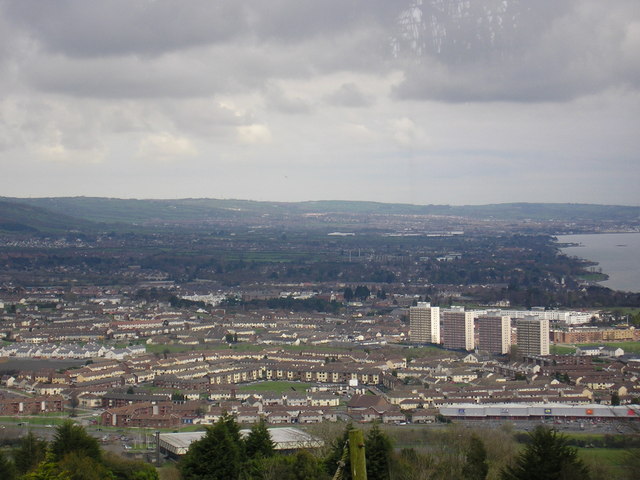 Overlooking the Rathcoole area of Newtownabbey from Cavehill | |
 Location within Northern Ireland | |
| Population | 65,646 (2011 Census) |
| District | |
| County |
|
| Country | Northern Ireland |
| Sovereign state | United Kingdom |
| Post town | NEWTOWNABBEY |
| Postcode district | BT36, BT37 |
| Dialling code | 028 |
| Police | Northern Ireland |
| Fire | Northern Ireland |
| Ambulance | Northern Ireland |
| UK Parliament |
|
| NI Assembly |
|
History
Founding
Newtownabbey Urban District was founded on 1 April 1958 to cover seven villages north of Belfast: Carnmoney, Glengormley, Jordanstown, Monkstown, Whiteabbey, Whitehouse and Whitewell.[2] Before this, the area fell under the jurisdiction of Belfast Rural District.
Newtownabbey Urban District Council was succeeded by Newtownabbey District Council (1973–1977), Newtownabbey Borough Council (1977–2015), and Antrim and Newtownabbey District Council (2015 onwards).
The Troubles
During The Troubles, there were a number of incidents in Newtownabbey, including several gun attacks involving the UFF and UVF.[3][4]
Geography

Newtownabbey is a large dispersed urban area north of Belfast, surrounding Carnmoney Hill. To its east is Belfast Lough, and to its south and west is Cavehill. There are two wooded river glens running through it: the Three Mile Water and the Glas-na-Bradan.
Townlands
Below is a list of townlands that are within Newtownabbey's urban area, alongside their likely etymologies.
- Ballybought (from Irish: Baile Bocht, meaning 'poor townland')*
- Ballyduff (from Baile Mhic Giolla Dhuibh, "MacElduff's townland")*
- Ballygolan (from Baile an Ghabhláin, "townland of the fork")*
- Ballyhenry (from Baile Éinrí, "Henry's townland")*
- Ballyvesey (possibly from Baile an Mheasa, "townland of the mast)*
- Ballywonard (from Baile an Mhuine Aird, "townland of the high thicket")*
- Carnmoney
- Collinward (possibly from Baile Gorán Bhaird, "townland of the bard's grove")*
- Croghfern (possibly from Currach Fearnaí, "marsh of the place of alders")*
- Drumnadrough (from Droim na gCruach, "the ridge of the stacks")*, site of Merville Garden Village
- Dunanney (from Dún Áine, "Áine's fort")*
- Glengormley
- Jordanstown
- Mallusk
- Monkstown
- Whiteabbey
- Whitehouse (named after a 16th-century fortified house built by an English adventurer; formerly Ballyrintollard)
Other districts include:
- Mossley (named after Mossley in England; in Ballyhenry townland)
- Rathcoole
- Whitewell (named after a former spring; in Ballygolan townland)
* citation for derivations[5]
Demography
On census day (27 March 2011) there were 65,646 people living in Newtownabbey.[1] Of these:
- 20.26% were aged under 16 years and 15.51% were aged 60 and over
- 48.02% of the population were male and 51.98% were female
- 62.21% were from a Protestant or other Christian backgrounds, and 27.69% were from a Catholic background
- 6.40% had some knowledge of the Irish language and 6.98% had some knowledge of Ulster-Scots.
Education
- Higher-level education
- University of Ulster at Jordanstown (UUJ)
- Northern Regional College (NRC)
- Secondary-level education
- Belfast High School
- Edmund Rice College
- Glengormley High School
- Primary-level education
- Jordanstown Schools for the Deaf and Blind
- Whitehouse Primary School
- Ashgrove Primary School
- Carnmoney Primary School
Sport
There are several association football clubs in Newtownabbey, including several amateur clubs which field teams in the Northern Amateur Football League: 18th Newtownabbey Old Boys F.C., Mossley F.C., Nortel F.C., Rathfern Rangers F.C., and Ulster University at Jordanstown F.C.[citation needed] Rathcoole F.C. plays in the Ballymena & Provincial Football League.[citation needed] As of 2020, Belfast Deaf United Football Club played in the Down Area Winter Football League.[6]
Local Gaelic games clubs include St Enda's GAC (based near Glengormley) and Greencastle Wolfe Tones GAC (based at Greencastle). Both participate in competitions organised by the Antrim County Board.[citation needed]
Hockey teams based in Newtownabbey include East Antrim Hockey Club, Mossley Hockey Club, and Owls Hockey Club. There are also a number of rugby clubs, an amateur boxing club (Glengormley Amateur Boxing Club), and several cricket teams. These include the Academy and Cliftonville Cricket Clubs (the latter participating in the NCU Senior League).[citation needed]
Outdoor Bowling Clubs in Newtownabbey include Mossley Bowling Club, Glengormley Bowling Club, Nortel Bowling Club and Ulster Transport Bowling Club.
Transport
Rail
Northern Ireland Railways runs trains serving three railway stations: Mossley West railway station on the Belfast–Derry railway line and Jordanstown railway station and Whiteabbey railway station on the Belfast–Larne railway line.
Road
Newtownabbey is linked to the M2 motorway (which passes through it) and the M5 motorway (which begins at its southeastern edge).
Bus services are provided by Translink’s Belfast bus service, Metro.[citation needed]
Notable people
- Stephen Boyd (4 July 1931 - 2 June 1977), Golden Globe-winning actor, was born in Glengormley.[7]
- Bobby Sands (9 March 1954 - 5 May 1981), Provisional Irish Republican Army member and hunger striker.
- James Brown (born 1968), Elvis impersonator, lives in Newtownabbey.[8]
- Ronan Bennett (born 14 January 1956), novelist and screenwriter, grew up in Newtownabbey.[9]
- James Fenton (5 June 1931 – 3 February 2021), Ulster Scots poet.[citation needed]
- Dean McCullough (born July 1992), British radio personality.
- Leah McFall (born 1 July 1986), singer-songwriter, was born in Newtownabbey.[10]
Twin towns
Newtownabbey is twinned with:
Newtownabbey has one sister city, as designated by Sister Cities International:
 Gilbert, Arizona , United States
See also
- List of localities in Northern Ireland by population
References
- "Census 2011 Population Statistics for Metropolitan Newtownabbey Settlement". Northern Ireland Statistics and Research Agency (NISRA). Retrieved 15 August 2019.
- "Newtownabbey". Place Names NI.
- "Sutton Index of Deaths, 1974". Conflict Archive on the Internet (CAIN). Retrieved 2 September 2006.
- "Sutton Index of Deaths, 1994". Conflict Archive on the Internet (CAIN). Retrieved 2 September 2006.
- "Place Names NI".
- "Football". dsni.co.uk. Disability Sport Northern Ireland. Archived from the original on 3 February 2020.
Belfast Deaf United [..] play in the Premier Section of the Down Area Winter League
- "Stephen Boyd: The Busker Who Became a Screen Idol". bbc.co.uk. BBC News. 8 January 2011.
- "Me and my health: Jim 'The King' Brown - The hip-swivelling I do on stage as Elvis gives me sore joints". Belfast Telegraph. 23 January 2018.
- "Six things you didn't know about Ronan Bennett, the NI writer behind Netflix's Top Boy". belfasttelegraph.co.uk. Belfast Telegraph. 30 September 2019.
- "Newtownabbey Girl to Sing on BBC 1 Show The Voice". belfastdaily.co.uk. 11 April 2013. Retrieved 24 August 2021.
- "Rybnik Official Website – Twin Towns". 2008 Urząd Miasta Rybnika. Retrieved 1 November 2008.
- "List of Twin Towns in the Ruhr District" (PDF). Archived from the original (PDF) on 28 November 2009. Retrieved 28 October 2009.
External links
- Antrim & Newtonabbey Borough Council official website
- Culture Northern Ireland - Newtownabbey (archived)
Towns in Northern Ireland | ||
|---|---|---|
List of towns by population | ||
| Large |
|  |
| Medium | ||
| Small |
| |
Italics denote settlements that are classed as towns but also have city status
| ||
Places in County Antrim | ||
|---|---|---|
List of places in County Antrim | ||
| Cities |
|  |
| Towns |
| |
| Villages |
| |
| Townlands |
| |
| Landforms |
| |
| Baronies |
| |
| ||
Authority control | |
|---|---|
| General | |
| National libraries | |
| Other | |
На других языках
- [en] Newtownabbey
[ru] Ньютаунабби
Ньютауна́бби (англ. Newtownabbey, ирл. Baile Nua na Mainistreach) — большой город района Ньютаунабби, крупнейший центр района, находящийся в графстве Антрим Северной Ирландии.Другой контент может иметь иную лицензию. Перед использованием материалов сайта WikiSort.org внимательно изучите правила лицензирования конкретных элементов наполнения сайта.
WikiSort.org - проект по пересортировке и дополнению контента Википедии