world.wikisort.org - United_Kingdom
Larne (from Irish: Latharna, IPA:[ˈlahəɾˠnˠə], the name of a Gaelic territory)[1][2][3] is a town on the east coast of County Antrim, Northern Ireland, with a population of 18,755 at the 2011 Census.[4][5] It is a major passenger and freight roll-on roll-off port.[6] Larne is administered by Mid and East Antrim Borough Council. Together with parts of the neighbouring districts of Antrim and Newtownabbey and Causeway Coast and Glens, it forms the East Antrim constituency for elections to the Westminster Parliament and Northern Ireland Assembly. The civil parish is in the historic barony of Glenarm Upper.[7]
Larne
| |
|---|---|
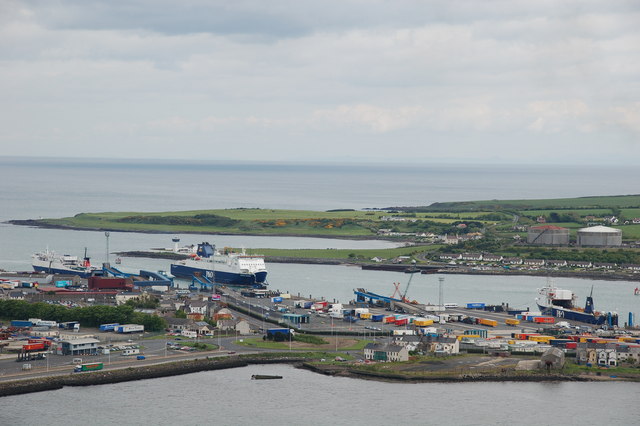
 2020 view looking south-east towards Larne Harbour, Islandmagee, and down the length of Larne Lough | |
 Larne Coat of Arms | |
 Larne Location within Northern Ireland | |
| Population | 18,755 (2011 Census) |
| Irish grid reference | D4102 |
| • Belfast | 30 km (19 mi) |
| District |
|
| County |
|
| Country | Northern Ireland |
| Sovereign state | United Kingdom |
| Post town | LARNE |
| Postcode district | BT40 |
| Dialling code | 028 |
| Police | Northern Ireland |
| Fire | Northern Ireland |
| Ambulance | Northern Ireland |
| UK Parliament |
|
| NI Assembly |
|
History

The coastal area around Larne has been inhabited for millennia, and is thought to have been one of the earliest inhabited areas of Ireland, with these early human populations believed to have arrived from Scotland via the North Channel. Knockdhu, north of Larne, was the site of a Bronze Age promontory fort and settlement. The early coastal dwellers are thought to have had a sophisticated culture which involved trading between the shores of the North Channel and between other settlements on the coasts of Scotland. The coast of Scotland is in fact clearly visible from here. Archaeological digs in the area have found flintwork and other artefacts which have been assigned dates from 6000 BC onwards. The term Larnian has even been coined by archaeologists to describe such flintworks and similar artefacts of the Mesolithic era (and one time to describe Mesolithic culture in Ireland as a whole).[8][9][10] Larnian is also currently used to refer to people from Larne.
Larne takes its name from Latharna, a Gaelic territory or túath that was part of the Ulaid minor-kingdom of Dál nAraidi.[11] The name spelt as Latharne was used at one point in reference to the Anglo-Norman cantred of Carrickfergus.[11] Latharna itself means "descendants of Lathar", with Lathar according to legend being a son of the pre-Christian king Úgaine Mór.[12] The town sprang up where the River Inver flows into Larne Lough. This area was known in Irish as Inbhear an Latharna ("rivermouth/estuary of Latharna")[13] and was later anglicised as Inver Larne or simply Inver. Latharna was only applied exclusively to the town in recent centuries.
There was Viking activity in the area during the 10th and 11th centuries AD. Viking burial sites and artefacts have been found in the area and dated to that time.[14] Ulfreksfjord was an Old Norse name for Larne Lough. According to the Norse historian Snorri Sturluson, Connor, King of Ireland, defeated Orkney Vikings at Ulfreksfjord in 1018. Later anglicised names include Wulfrichford, Wolderfirth, Wolverflete and the surviving name Olderfleet. The ending -fleet comes from the Norse fljot, meaning "inlet".[15] Older- may come from the Norse oldu, meaning "wave".[15]

In the 13th Century the Scots Bissett family built Olderfleet Castle at Curran Point. In 1315, Edward the Bruce of Scotland (brother of Robert the Bruce, King of Scotland) landed at Larne with his 6000 strong army en route to conquer Ireland, where Olderfleet Castle was of strategic importance. Edward saw Ireland as another front in the ongoing war against Norman England.
In 1569, Queen Elizabeth I, Queen of England and Ireland, appointed Sir Moyses Hill as the governor of Olderfleet Castle. It was seen as strategically important for any Tudor conquest of Ulster. Following the 17th century Union of the Crowns of Scotland, England and Ireland under James VI & I many more settlers would have arrived to Ulster via Larne during the Plantation of Ulster. The area around County Antrim itself, however, was not part of the official 17th century Plantation; instead many Scottish settlers arrived in the area through private settlement in the 17th century (as they had also been doing for centuries before).
During the 18th century many Scots-Irish emigrated to America from the port of Larne. A monument in the Curran Park commemorates the Friends Goodwill, the first emigrant ship to sail from Larne in May 1717, heading for Boston, Massachusetts in the New England region of the modern United States of America. Boston's long standing Scots-Irish roots can be traced to Larne. The town is documented as being the first in county Antrim to be taken by United Irishmen during the ill-fated rebellion of 1798. The Protestant rebels from this area (almost entirely Presbyterian) filled Larne and engaged the government forces around 2am on the morning of 7 June. This surprise attack drove the garrison to flee the town, at which point the rebel force marched off to join up with McCracken and fight in the Battle of Antrim.[16]
In 1914, Loyalists opposed to the Home Rule Act 1914 prepared for armed resistance. In an episode known as the Larne Gun Running German, Austrian and Italian weapons with ammunition were transported into the ports of Larne and Bangor in the dead of night and distributed throughout Ulster.[17] This event marked a major step in cementing the right to Ulster Unionist self-determination, with the recognition of such a right ultimately leading to the creation of Northern Ireland.
The Troubles
Larne throughout the course of The Troubles had a significant paramilitary presence in the town, mostly through the presence of the Ulster Volunteer Force (UVF) and Ulster Defence Association (UDA). For further information see UDA South East Antrim Brigade.
The town suffered a number of Provisional Irish Republican Army (IRA) bomb attacks during The Troubles, notably including a large car bomb at the King's Arms hotel[18] in 1980 that caused damage to the main shopping areas, for which the IRA claimed responsibility. This incident was raised in Parliament at the time.[19]
Incidents which involved fatalities
- 16 September 1972: Sinclair Johnston a UVF member, was shot by the Royal Ulster Constabulary during street disturbances in the town when the Royal Ulster Constabulary were protecting Catholics living in St Johns Place.[20]
- 20 November 1974: Kevin Regan died from his injuries received in a UVF attack five days before on Maguires bar on Lower Cross Street. The Larne UDA blamed the IRA for the attack.[21]
- 6 February 1975: Colette Brown, a Catholic, was found by the side of the Killyglen Road after being shot by Loyalists.[22] Two men, one a UVF member the other a Lance Corporal in the UDR (Ulster Defence Regiment) were later convicted of her murder.[23]
- 8 September 1975: Michael O'Toole a Catholic, died from his injuries sustained in a loyalist booby trap bomb attached to his car two days previously.[24]
- 24 August 1980: Rodney McCormick a Catholic, was shot dead by the Ulster Defence Association (UDA) in the Antiville area of the town. The Royal Ulster Constabulary convicted the gunmen involved.[25]
- 11 July 2000: Andrew Cairns a UVF member, was killed by members of the UDA[26] at an eleventh night bonfire celebration in a suspected loyalist feud at Boyne Square. He may also have been murdered due to his alleged involvement in an earlier assault.[27] The Royal Ulster Constabulary detective inspector, George Montgomery, did not find any motive for the murder. David Ervine (PUP) stated that there was no Loyalist feud.[28]
Geography

In the foreground is Islandmagee in Northern Ireland, followed by Stena Line ferries entering and leaving Larne, and The Maidens lighthouses.
In the background are the Scottish Paps of Jura on the left and Mull of Kintyre on the right.
Larne sits on the western side of a narrow inlet that links Larne Lough to the sea. On the eastern side of the inlet is a peninsula called Islandmagee. To the west of Larne is the ancient volcanic formation of Antrim Plateau, with its glaciated valleys scenically sweeping down to the sea to the north of Larne in what are known as the Glens of Antrim. Larne is 25 miles from the Scottish mainland, with views across the North Channel towards the Mull of Kintyre, Rhins of Galloway, Islay and Paps of Jura often visible from the Larne area – this proximity to Scotland has had a defining influence on Larne's history and culture.
The town is within the small parish of the same name. Like the rest of Ireland, this parish is divided into townlands. The following is a list of townlands within Larne's urban area, along with their likely etymologies:[29]
- Antiville (likely from An Tigh Bhile meaning "the house of the old tree")
- Ballyboley (from Baile Buaile meaning "townland of the booley/dairy place")
- Ballycraigy (from Baile Creige meaning "townland of the rocky outcrop")
- Ballyloran (from Baile Loairn meaning "Loarn's townland")
- Blackcave North
- Blackcave South
- Curran and Drumalis (from Córran meaning "crescent" and Druim a' Lios meaning "ridge of the ringfort")
- Greenland
- Inver (from Inbhear meaning "rivermouth")
Many streetnames in Larne end in brae, such as 'Whitla's Brae' which comes from the Scots for "hillside".
Civil parish of Larne
The civil parish contains the following townlands:[7] Antiville, Ballyboley, Ballycraigy, Ballyloran, Blackcave North, Blackcave South, Curran and Drumaliss, Glebe, Greenland and Town Parks.
Gallery


Places of interest
This section reads like a directory. (August 2021) |


- The town has several parks:[30]
- The Town Park sits above the promenade area, with walks from Waterloo Bay towards the Chaine Memorial Tower at Sandy Bay – a lighthouse and memorial to the founder of Larne Harbour sea route to Scotland. The Leisure Centre is nearby. The Promenade leads on to .
- The Chaine Park contains the burial site of James Chaine and has views over the North Channel.
- The Curran park has a large children's play area, bowling facilities and camping. There are also tributes to emigrants to North America and Larne's connections with North America.
- The Dixon Park contains a 2 hectare open green space area with bandstand.
- Smiley park is a small park in the centre of the town also with tributes to emigrants to North America who left from the port of Larne.
- Playing fields and cricket grounds at Sandy Bay.
- Carnfunnock Country Park, 3.5 miles north of Larne is a large site with camping, caravanning, gardens, maze of Northern Ireland, sundials, children's play area, mini-golf, 9 hole pitch and putt golf course, Miniature railway, WOW balls, treasure trails, orienteering course, and walks.
- Larne Leisure Centre offers a 25m indoor swimming pool, spa, sauna, weights, fitness, sports hall and theatre. It is situated at Sandy Bay near the picturesque Promenade area.[31]
- Larne Museum & Arts Centre, situated in the Carnegie Centre in the centre of the town.[32]
- Olderfleet Castle is the ruins of a 13th-century castle at Curran Point, near the Chaine Memorial Tower.
- Cairndhu Golf Course is an 18-hole course situated atop of Ballygally Head.[33] Larne Golf Course on sits atop of the Islandmagee peninsula[34]
- Nearby sandy beaches at:
- Sandy Bay (small beach)
- Drains Bay, just to the northern edge of the town.
- Ballygally, 5 miles north from centre of Larne. Ballygally Beach has recently won top awards for cleanliness[35] and is rated to have top water quality for bathing.
- Browns Bay at the tip of Islandmagee formerly offered camping and caravanning (campsite closed 2015).
- Glenarm, 10 miles north from centre of Larne.
- Carnlough, 12 miles north from centre of Larne.
- Waterfalls and forest walk are at nearby Glenoe, 5 miles inland.
- Magheramorne, 5 miles to the south along Larne Lough, has a marina; a Mountainbiking course and an all-Ireland diving centre are currently under construction at the old Magheramorne lime quarry and cement works.[citation needed][36] The film studio at Magheramorne was used to film much of HBO TV Series Game of Thrones, where the quarry wall was used as a back-drop for much of the series, along with scenery at the Antrim Plateau near Cairncastle.
- Diving tours are also available off the coast. The lighthouse on The Maidens rocks hosts a colony of seals. Numerous coastal bird species and other wildlife such as otters, whales and dolphins are often visible along the Larne coastal area.
- Castle and estate of the Earl of Antrim in the nearby fishing village of Glenarm, 12 miles north, has walled gardens and often hosts Ulster Scots cultural events such as the Dalriada Festival and Highland Games.
- Drumalis Retreat & Conference Centre, is based in Drumalis House built by Hugh Smiley owner of the Northern Whig newspaper, owned by the Sisters of the Cross and Passion since 1930.
- Larne Lough is a protected bird-watching area and designated Special Protection Area, Area of Special Scientific Interest and Ramsar wetland site to protect both birds and shellfish.
Demography
On Census day (27 March 2011) there were 18,755 people living in Larne, accounting for 1.04% of the NI total.[4] Of these:
- 18.59% were aged under 16 years and 18.00% were aged 65 and over;
- 51.98% of the usually resident population were female and 48.02% were male;
- 67.03% belong to or were brought up Protestant and other non-Catholic Christian (including Christian related) and 25.97% belong to or were brought up Catholic;
- 71.62% indicated that they had a British national identity, 30.56% had a Northern Irish national identity and 8.75% had an Irish national identity (respondents could indicate more than one national identity);
- 41 years was the average (median) age of the population;
- 17.20% had some knowledge of Ulster-Scots and 4.02% had some knowledge of Irish (Gaelic).
Industry and commerce

Ballylumford power station in Northern Ireland's main power station, and provides half of all Northern Ireland's electricity.[citation needed] Other energy operators in Larne include B9 Energy (a renewable energy development company)[37] and Wind NI (Wind Power Development Solutions).[citation needed]
Larne is also home to the headquarters of Caterpillar (NI) Limited (part of the Caterpillar group which manufactures diesel and gas generators),[38] InspecVision (industrial inspection equipment),[citation needed] TerumoBCT (a Japanese manufacturer of intravenous drip solutions and blood products),[39] and the LEDCOM (Larne Enterprise Development Company) business park.[40]
A number of shops can be found along Larne Main Street, Dunluce Street, Laharna Retail Park, and large supermarkets off the Harbour Highway near the harbour. A market is also held every Wednesday at the Larne Market Yard.[41]
Transport
Ferry
Ferries sail from the harbour to Cairnryan in Scotland. Passenger services are operated by P&O Irish Sea which describes the crossings from Larne to Scotland as "the shortest, fastest crossings" due to the close proximity that Larne has to Scotland. An Irish Sea Bridge has been proposed, connecting Larne with Portpatrick in Scotland.
Road

Larne is connected to Belfast by the A8 road. The A2 road or 'Antrim coast road' which runs along the Antrim coast, and passes through the scenic Glens of Antrim, also serves the town. South of the town the A2 passes the side of Larne Lough, via Glynn, Magheramorne, and Ballycarry, to Whitehead and Carrickfergus. The A36 road runs from the town to Ballymena.
Rail
The Belfast–Larne railway line connects to Belfast Great Victoria Street railway station and Belfast Central, via Whitehead, Carrickfergus and Jordanstown, also connects Larne to the Northern Ireland Railways network. Currently there is no freight transport by rail in Northern Ireland. Both Larne Town railway station and Larne Harbour railway station opened on 1 October 1862 and closed for goods traffic on 4 January 1965.[42]
The Ballymena and Larne Railway was a narrow gauge railway. It opened in 1878, was closed to passengers in 1933 and finally completely closed in 1950. Another line ran from Larne to Ballyclare and some parts of it can still be made out where it ran along the Six Mile valley.
Public services

Larne Town Hall, the former headquarters of Larne Borough Council, was completed in 1870.[43] Other public facilities include Larne's fire station, public library, police station (PSNI) and ambulance station.[citation needed]
Moyle Hospital offers limited services after the closure of its accident and emergency department. Larne Lifeboat Station is operated by the RNLI.[citation needed]
Education
There are a number of educational establishments in the area, including at least ten primary schools.[citation needed]
Secondary schools serving the area include Larne Grammar School and Larne High School.[citation needed]
Northern Regional College (formerly Larne Technical College) is a college of further education.[citation needed]
Notable people
- Smiley baronets, series of baronets important in History of Larne
- Dianne Barr, paralympic swimmer
- Billy Brown, musician
- James Chaine, Member of Parliament
- Dave Clements, footballer and football manager
- Fyfe Ewing, musician, drummer (Therapy?)
- Robert Ferguson, disc jockey
- Keith Gillespie, Sheffield United and Northern Ireland midfielder.
- Robert John Gregg, pioneer of the academic study of Ulster-Scots dialects as well as a linguistic authority on Canadian English
- Mark Haggan, activist
- Richard Hayward, actor/singer, author
- Valerie Hobson, actress
- Jeff Hughes, footballer
- Michael Hughes, Wimbledon and Coventry City footballer
- Whitford Kane, actor
- Valerie Lilley, actor (Shameless)
- Phillip Magee (The X Factor, series 2 finalist
- Sir Ivan Magill, innovating anaesthetist; went to Larne Grammar school
- Dave McAuley, former IBF Flyweight world champion boxer
- Gareth McAuley, current West Bromwich Albion defender
- Colin McGarry Professional Darts Corporation player
- Adam McGurk, footballer
- James McIlroy Olympic runner
- Bobby McKee, Democratic Unionist Party councillor; former Mayor of Larne[44]
- Jack McKee, alderman and veteran loyalist politician
- Michael McKeegan, musician (Therapy?)
- Amanda McKittrick Ros, author, poet; taught at Millbrook National School during the 1880s
- Eddie McMorran, footballer
- Eddie Mooney, musician (The Dakotas, The Fortunes)
- Hugh Nelson, Lieutenant Governor of British Columbia (1830–1893)
- Robert Nelson, electronic music producer (Agnelli & Nelson)
- Jonathan Rea, Superbike World Championship rider
- Keith Semple, (One True Voice from the ITV series Popstars: The Rivals)
- Norman Surplus, first person to complete a circumnavigation of Earth by Autogyro
- Harry Towb, actor
Freedom of the borough
In memory of a battle in the town of Musa Qala in Afghanistan in 2006, involving the Royal Irish Regiment, a new regimental march, composed by Chris Attrill and commissioned by Larne Borough Council, was gifted to the regiment on Saturday 1 November 2008 in Larne, during an event in which the regiment was presented with "the Freedom of the Borough".
This gave the regiment the right to march through the towns of the borough with 'flags flying, bands playing and bayonets fixed'. The march was named Musa Qala.[45]
Events
This section does not cite any sources. (August 2021) |
The Larne Civic Parade takes place on the first weekend in June, when Larne Town Centre is closed for a few hours.[citation needed]
The Goodwill Music Festival occurs on the second weekend in May.[citation needed] The music festival occurs over a number of days and celebrates the Irish immigration taken in the 18th and 19th centuries to the promise land of America.[citation needed]
The "Pop-Up Emporium Christmas Twilight Market" occurs yearly in early December at the Larne Market Yard. This market has live music and many local independent crafts, artisans, food, drink and other businesses involved.[citation needed]
An annual half marathon takes place mid-March and is one of the most popular half-marathons in the Northern Ireland with most of the route taking place on the East Antrim Coast Road.[citation needed]
Sport
Larne F.C., a professional association football club, plays in the NIFL Premiership. Local amateur football clubs include Larne Technical Old Boys F.C. and Wellington Recreation F.C.[citation needed]
Latharna Óg GAA is a local Gaelic games club. Larne also has a number of rugby, hockey, cricket and golf clubs. As a coastal town, there are also several rowing, boating, angling and swimming clubs.[citation needed]
Twin city
Larne is twinned with Clover, South Carolina, which has named one of its schools, Larne Elementary School,[46] after Larne.
Notable facts
- Larnite – this mineral is named after Larne.[47]
See also
- List of civil parishes of County Antrim
- List of localities in Northern Ireland by population
- List of RNLI stations
References
- Larne/Latharna. Placenames Database of Ireland.
- "Postal Towns/Bailte Poist" (PDF). Archived from the original (PDF) on 7 February 2012.. Northern Ireland Place-Name Project. Queen's University Belfast.
- Room, Adrian. Placenames of the World. McFarland, 2006. p.213
- "Census 2011 Population Statistics for Larne Settlement". Northern Ireland Statistics and Research Agency (NISRA). Retrieved 10 August 2019.
- "Census 2011 Population Statistics for Larne Local Government District". Northern Ireland Statistics and Research Agency (NISRA). Retrieved 17 January 2017.
- Tibus, Website design and website development by. "Port Of Larne – About Us – History". Archived from the original on 10 March 2019. Retrieved 16 April 2017.
- "Larne". IreAtlas Townlands Database. Retrieved 20 April 2015.
- "Larne Borough council – Local History and Heritage". Archived from the original on 8 April 2015. Retrieved 16 April 2017.
- "Answers – The Most Trusted Place for Answering Life's Questions". Answers.com. Retrieved 16 April 2017.
- "Larnian industry – ancient culture". Retrieved 16 April 2017.
- MacCotter, Paul (31 October 2014). Medieval Ireland. Territorial, Political and Economic Divisions. The Heritage Council. ISBN 9781846825576.
- Place Names Northern Ireland. "Larne, County Antrim". Retrieved 29 August 2016.
- Patrick Weston Joyce (1870). Irish Local Names Explained. Retrieved 10 October 2020 – via Library Ireland.
- "Fejl: Siden blev ikke fundet / adgang er ikke tilladt". Archived from the original on 16 July 2012. Retrieved 16 April 2017.
- Geoffrey Malcolm Gathorne-Hardy. The Norse Discoverers of America. Clarendon Press, 1921.
- Hope, J., & Newsinger, J. (2001). United Irishman : the autobiography of James Hope: The autobiography of James Hope. p33-34 London: Merlin.
- A. T. Q. Stewart: "The Ulster Crisis", London, Faber and Faber Ltd., 1967 SBN 571 08066 9
- "PaceMaker Press". Retrieved 16 April 2017.
- "Terrorist Incident (Larne) (Hansard, 6 May 1980)". Retrieved 16 April 2017.
- David McKittrick et al Lost Lives page 264-265
- David McKittrick et al Lost Lives page 495-496
- David McKittrick et al Lost Lives page 514-515
- David McKittrick et al Lost Lives page 366
- David McKittrick et al Lost Lives page 575-576
- David McKittrick et al Lost Lives page 836
- UVF man shot as loyalists fall out | UK news | The Guardian https://www.theguardian.com/uk/2000/jul/13/northernireland.jamiewilson
- David McKittrick et al Lost Lives page 1478-1479
- "BBC News – NORTHERN IRELAND – Fresh appeal after bonfire murder". Retrieved 16 April 2017.
- "Northern Ireland Placenames Project". Retrieved 12 June 2010.
- "Larne Borough Council overview". Archived from the original on 8 April 2015. Retrieved 16 April 2017.
- "Leisure Centre". Archived from the original on 14 May 2012. Retrieved 16 April 2017.
- "bB査定☆超簡単に高額査定ゲット!わかりやすく解説しています". Retrieved 16 April 2017.
- "Home". Retrieved 16 April 2017.
- "Home". Retrieved 16 April 2017.
- "Ballygally and Carnlough beaches win UK awards". Retrieved 16 April 2017.
- "Magheramorne reinvented by Lafarge". Archived from the original on 28 June 2016. Retrieved 16 April 2017.
- Energy, B9. "B9 Energy Homepage". Retrieved 16 April 2017.
- "FGW – Contact Us". Retrieved 16 April 2017.
- "Terumo BCT". Retrieved 16 April 2017.
- "LEDCOM -Expert business advice and resources in Larne and Co. Antrim". Retrieved 16 April 2017.
- "Larne Borough Council – Larne Market". Archived from the original on 1 April 2014. Retrieved 16 April 2017.
- "Larne stations" (PDF). Railscot – Irish Railways. Retrieved 28 August 2007.
- "Town Hall (HB 06/12/002)". Department for Communities. Retrieved 29 June 2021.
- "Bobby McKee elected new Mayor of Larne". Larne Times. Johnston Publishing. 12 June 2008. Retrieved 11 August 2014.
- "New march to be gifted at Larne ceremony". Archived from the original on 12 September 2012. Retrieved 16 April 2017.
- "Larne Elementary School / Homepage". Retrieved 16 April 2017.
- Larnite Mineral Data
Further reading
- Cowsill, Miles (1998). Stranraer–Larne: The Car Ferry Era. Narberth, Pembrokeshire: Ferry Publications. ISBN 1871947405.
External links
Towns in Northern Ireland | ||
|---|---|---|
List of towns by population | ||
| Large |
|  |
| Medium | ||
| Small |
| |
Italics denote settlements that are classed as towns but also have city status
| ||
Places in County Antrim | ||
|---|---|---|
List of places in County Antrim | ||
| Cities |
|  |
| Towns |
| |
| Villages |
| |
| Townlands |
| |
| Landforms |
| |
| Baronies | ||
| ||
Authority control | |
|---|---|
| General | |
| National libraries | |
| Other |
|
На других языках
- [en] Larne
[ru] Ларн
Ла́рн (англ. Larne, ирл. Latharna) — индустриальный город, расположенный в районе Антрим, Северная Ирландия. Является основным пассажирским и грузовым портом Северной Ирландии с тысячелетней историей в этом качестве. По данным на 2001 год в городе проживает 18228 человек. Административное управление осуществляется Городским советом Ларна. Вместе с соседними районами Кэррикфергюс и частично Ньютаунэбби формирует избирательный округ «Восточный Антрим» для выборов в Парламент Великобритании и Ассамблею Северной Ирландии.Другой контент может иметь иную лицензию. Перед использованием материалов сайта WikiSort.org внимательно изучите правила лицензирования конкретных элементов наполнения сайта.
WikiSort.org - проект по пересортировке и дополнению контента Википедии