world.wikisort.org - United_Kingdom
Lochaline (Scottish Gaelic: Loch Àlainn) is the main village in the Morvern area of Highland, Scotland. The coastal village is situated at the mouth of Loch Aline, on the northern shore of the Sound of Mull. A ferry operates regularly over to Fishnish on the Isle of Mull.
Lochaline
| |
|---|---|
 Lochaline | |
 Lochaline Location within the Lochaber area | |
| OS grid reference | NM6744 |
| Civil parish | |
| Council area | |
| Lieutenancy area |
|
| Country | Scotland |
| Sovereign state | United Kingdom |
| Post town | OBAN |
| Postcode district | PA80 |
| Dialling code | 01967 |
| Police | Scotland |
| Fire | Scottish |
| Ambulance | Scottish |
| UK Parliament |
|
| Scottish Parliament |
|
Population
The current population[1] of Lochaline is around 200 people.
In 1930, some Gaelic-speaking residents of the archipelago of St Kilda were evacuated by Williamina Barclay and relocated to Lochaline. Many of them lived and settled in Lochaline, although with some difficulty.[2]

Transport
A regular ferry operated by Caledonian MacBrayne runs over to Fishnish on the Isle of Mull. The ferry takes only about 20 minutes, runs multiple times a day,[3] and day trips from Lochaline are possible.
A snack bar by the pier is opened daily, offering hot and cold take-away snacks and beverages for the journey.
There is also an infrequent bus service, 507, operated by Shiel Buses - this runs Tuesdays and Thursdays to Fort William in the morning, returning mid-afternoon. Additional journeys are run as far as Ardnamurchan High School on schooldays only.
Facilities
The village's facilities include a grocery shop, post office, petrol station, hotel, restaurant, social club, marina, snack bar and public conveniences.

The menu of the White House restaurant includes ingredients which are foraged and sourced locally.[4]
The Lochaline hotel, with its beach, has views of the Sound of Mull and the ruins of the old Ardtornish castle.
Local attractions
The village is popular with divers,[citation needed] as it is close to the wrecks of the Sound of Mull, with several charter boats available locally.[citation needed]
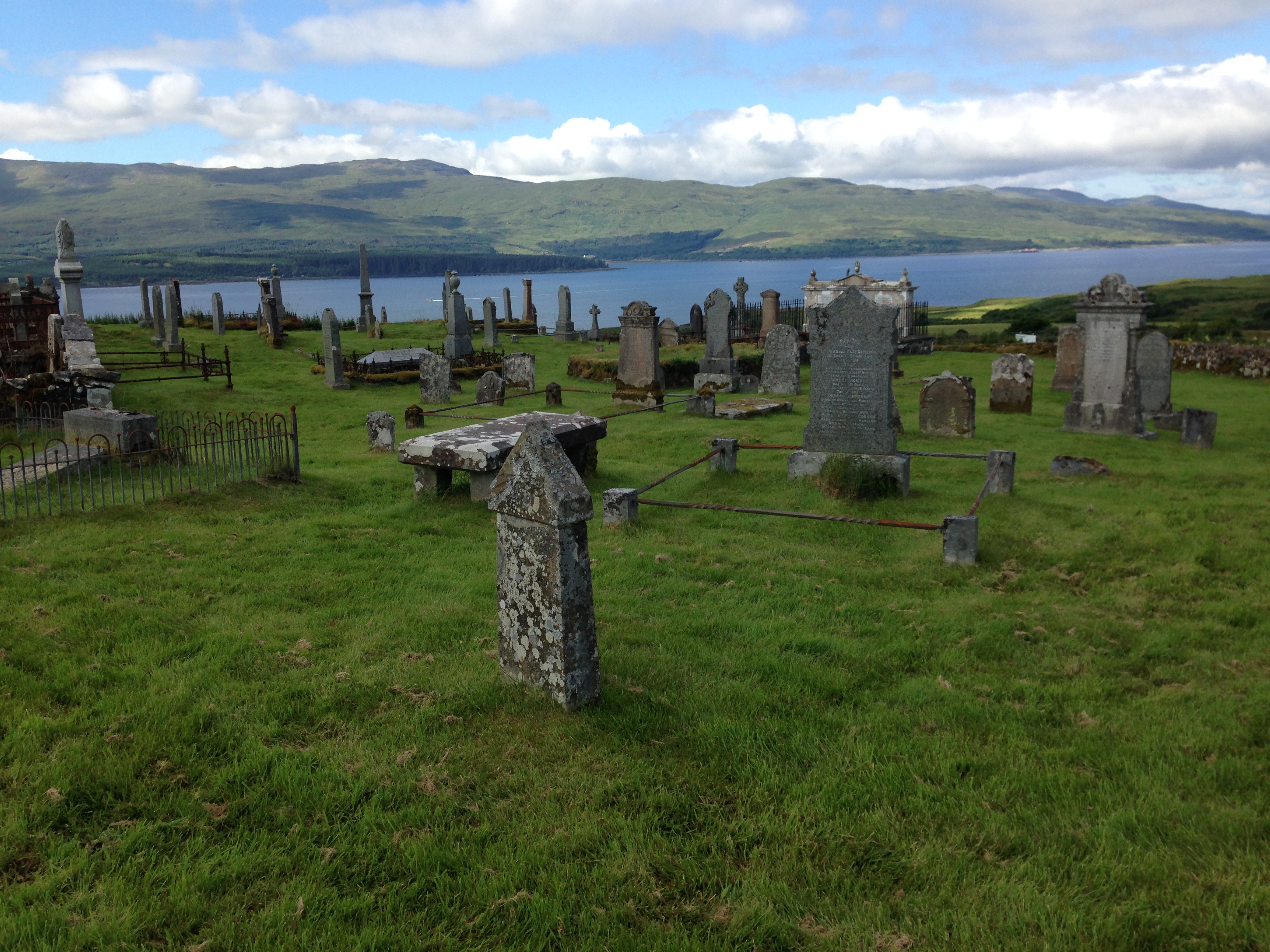
Kiel Church
Set in trees overlooking the Sound of Mull, Kiel Church with a graveyard is one mile away from Lochaline. The interior of the 19th-century church is plain with a braced timber roof. More than 17 medieval carved gravestones[5] are displayed in the church. They are a reminder of the late medieval flowering of Gaelic culture associated with the Lordship of the Isles.[citation needed] Designs include swords, ships and hunting scenes.
Other fragments of medieval stones lay in the graveyard, including a six hundred-year-old cross.
Kile takes its name from Cille Choluimchille, the religious cell or monastery of St Columba 'Of the Church' who travelled through Northern Scotland in the 6th-century A.D. with news of the Christian gospel and who built the first church here, as the tradition has it.
Ardtornish Estate
Ardtornish Estate spreads out around the bay of Loch Aline. The gardens of Ardtornish House are open to the public and include native and exotic plants and trees.[citation needed]
Ardtornish Castle
The castle was one of the principal seats of the high chiefs of Clan Donald from the early 14th to late 15th century, but Somerled had a fortress here in the mid-12th century. Ardtornish was the hub of strategic sea lanes vital to him. Later, it was at Ardtornish Castle that John of Islay, Lord of the Isles, 6th chief of Clan Donald died in the 1380s and from where his funeral procession sailed through the Sound of Mull to the island of Iona.
The castle was probably abandoned around the end of the seventeenth century, by which time the Campbell Earls of Argyll had captured Ardtornish and the other Morvern estates of the MacLeans.
Walking trails
The area around the village contains a number of walking paths. These include the coastal walks (the Kinlochaline Low Road and Ardtornish Castle Walk) along the shores of Loch Aline, a small salt water loch, home to fish and birds. Loch is the Scottish Gaelic word for a lake or a sea inlet.
Geology
A silica sand mine has been in Lochaline since 1940, when it was opened to replace sources of silica lost because of World War II.[6] A source was needed for the manufacture of optical quality glass. In November 2008, the announcement was made about closing the mine.[7]
In September 2012, the mine re-opened under a new company Lochaline Quartz Sand Ltd, a joint venture between the Italian mining company Minerali Industriali and glass manufacturer NSG.
The silica quartz and other minerals came from the erosion of the Scottish landmass. They were deposited on the shore of a tropical sea on Jurassic shales and limestones in the middle of the Cretaceous period, 93 million years ago, at the same time, the chalk cliffs of Dover were forming. Frequent changes to sea level reworked the sandy sediment. Natural winnowing processes sorted the quartz from other minerals, separating grains of similar size. For 60 million years, this was protected from erosion by a basalt covering from the Mull volcano.
Near the loch shoreline, today are fossil oysters, or Gryphaea, that lived on the shoreline of a tropical sea here 200 million years ago.[8] The rocks in this layer are the same age as the Jurassic Coast in Dorset.

Mentions of Lochaline
Author Madeleine Bunting mentions Lochaline in her book Love of Country, published in 2016. In the third chapter about the isle of Iona, she writes:
'At the end of the road in Lochaline at a hut by the jetty, rock cakes and scalding tea were on sale for waiting passengers. As the small ferry pulled away, the sea was sparkling in the late-afternoon sunshine.'
See also
- Ardtornish
- Ardtornish Castle
- Isle of Mull
- Iona
- Tobermory
- Fort William
References
- "Lochaline from The Gazetteer for Scotland". www.scottish-places.info. Retrieved 13 June 2022.
- The new biographical dictionary of Scottish women. Ewan, Elizabeth. Edinburgh. ISBN 9781474436298. OCLC 1057237368.
{{cite book}}: CS1 maint: others (link) - "Mull: Lochaline - Fishnish". CalMac Ferries. Retrieved 13 June 2022.
- "Our Food & Drink". thewhitehouse. Retrieved 13 June 2022.
- "MHG30660 - Keil Church - Lochaline - Highland Historic Environment Record". her.highland.gov.uk. Retrieved 13 June 2022.
- Exploring Morvern, Morvern Heritage Society, The Story of Lochaline Silica Mine, Mary Barnes, pages 14–19
- £Mine closes with loss of 11 jobs" Lochaber News, 20 November 2008]
- The Evolution of Gryphaea, Stephen Jay Gould, 1980.
На других языках
[de] Lochaline
Lochaline, schottisch-gälisch Loch Àlainn: „schöner See“,[1] ist mit etwa 200 Einwohnern der wichtigste Ort in Morvern, Council Area Highland. Es liegt an der Nordküste der Mündung des Fjordes Loch Aline und ist straßenseitig über die A884 zu erreichen. Lochaline ist per Fähre mit Fishnish auf der Isle of Mull verbunden und besitzt eine Tankstelle und einen Laden. Nahebei liegt eine etwa hundert Jahre alte Kirche, an deren Standort der Legende nach ein Vorgängerbau aus dem 6. Jahrhundert stammt. Die ältesten Grabsteine auf dem Friedhof datieren auf das 8. Jahrhundert.[2]- [en] Lochaline
Другой контент может иметь иную лицензию. Перед использованием материалов сайта WikiSort.org внимательно изучите правила лицензирования конкретных элементов наполнения сайта.
WikiSort.org - проект по пересортировке и дополнению контента Википедии