world.wikisort.org - United_Kingdom
Kensaleyre (Scottish Gaelic: Ceann Sàil Eighre) is a scattered crofting township, part of a group of settlements clustered around the A87 road on the shore of Loch Snizort Beag[1][2] on the Trotternish peninsula of the island of Skye in the Highlands and Islands of Scotland. It is in the council area of Highland.

Kensaleyre
| |
|---|---|
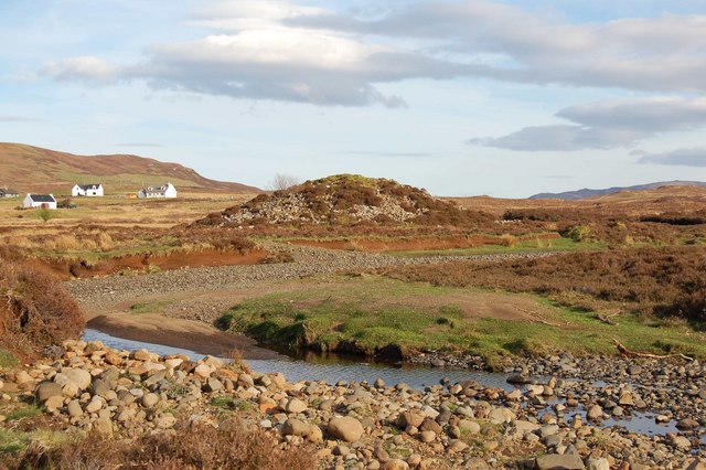 Carn Liath in Kensaleyre. This Carn Liath is one of many features of that name throughout the Scottish highlands. It is a four-metre-high (13 ft) chambered cairn. | |
 Kensaleyre Location within the Isle of Skye | |
| OS grid reference | NG422514 |
| Council area |
|
| Country | Scotland |
| Sovereign state | United Kingdom |
| Post town | Snizort |
| Postcode district | IV51 9 |
| Police | Scotland |
| Fire | Scottish |
| Ambulance | Scottish |
| UK Parliament |
|
| Scottish Parliament |
|
References
- Microsoft; Nokia (7 March 2017). "Kensaleyre" (Map). Bing Maps. Microsoft. Retrieved 7 March 2017.
- Gittings, Bruce; Munro, David. "Kensaleyre". The Gazetteer for Scotland. School of GeoSciences, University of Edinburgh and The Royal Scottish Geographical Society. Retrieved 17 August 2018.
Wikimedia Commons has media related to Kensaleyre.
This Highland location article is a stub. You can help Wikipedia by expanding it. |
Текст в блоке "Читать" взят с сайта "Википедия" и доступен по лицензии Creative Commons Attribution-ShareAlike; в отдельных случаях могут действовать дополнительные условия.
Другой контент может иметь иную лицензию. Перед использованием материалов сайта WikiSort.org внимательно изучите правила лицензирования конкретных элементов наполнения сайта.
Другой контент может иметь иную лицензию. Перед использованием материалов сайта WikiSort.org внимательно изучите правила лицензирования конкретных элементов наполнения сайта.
2019-2025
WikiSort.org - проект по пересортировке и дополнению контента Википедии
WikiSort.org - проект по пересортировке и дополнению контента Википедии