world.wikisort.org - United_Kingdom
Denny (Scottish Gaelic: Deanaidh) is a town in the Falkirk council area of Scotland. Historically in Stirlingshire, it is situated 7 miles (11 kilometres) west of Falkirk, and 6 miles (10 km) northeast of Cumbernauld, adjacent to both the M80 and M876 motorways. At the 2011 census, Denny had a resident population of 8,300.[2]
Denny
| |
|---|---|
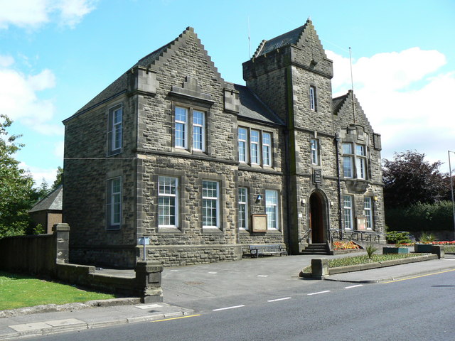 Denny Town House | |
 Denny Location within the Falkirk council area | |
| Area | 1.03 sq mi (2.7 km2) |
| Population | 8,500 (mid-2020 est.)[1] |
| • Density | 8,252/sq mi (3,186/km2) |
| OS grid reference | NS806818 |
| • Edinburgh | 28.5 mi (45.9 km) |
| • London | 348 mi (560 km) |
| Council area | |
| Lieutenancy area |
|
| Country | Scotland |
| Sovereign state | United Kingdom |
| Post town | DENNY |
| Postcode district | FK6 |
| Dialling code | 01324 |
| Police | Scotland |
| Fire | Scottish |
| Ambulance | Scottish |
| UK Parliament |
|
| Scottish Parliament |
|
| Website | falkirk.gov.uk |
History
Denny is separated from neighbouring village Dunipace by the River Carron.[3] A stone bridge was built over the river in 1825.[4] Denny Town House was completed in 1931.[5] Until the early 1980s, Denny was a centre for heavy industry, including several iron foundries,[6] brickworks, a coal mine and paper mills.[7]
The first phase of a £7.6 million regeneration scheme in the town centre was completed in 2017.[8]
Notable people
In the First World War 902 men signed up from Denny and Dunipace. Of those 154 were killed in action or died on service. Decorations were earned by 31 men.[9]
- Thomas Bain, politician
- John Adam Cramb, historian
- David Forrester, divine
- George William Gray, chemist
- Matthew Hay, doctor
- Carl Kirkwood, politician
- Christian Maclagan, archaeologist
- Stevie McCrorie, musician
- William Morehead, landowner
Sport
The local football team are Dunipace F.C., who play at Westfield Park where they moved to from their previous home of Carronbank. They compete in the East of Scotland Football League. Another team, Denny Hibs, operated in the Junior leagues from the 1900s to the 1930s – Dunipace were also part of that setup until the 2010s.
Notable sportspeople from Denny include:
- Sammy Baird, football player and manager
- Cameron Buchan, rower
- Martyn Corrigan, football player and manager
- Kenny Deuchar, footballer
- Willie Loney, footballer
- Niall Mackenzie, motorcycle racer
- Danny Malloy, boxer
- Jimmy McMullan, professional footballer
- Jim McNab, footballer
- Thomas Scott, footballer
- Billy Steel, footballer
References
Citations
- "Mid-2020 Population Estimates for Settlements and Localities in Scotland". National Records of Scotland. 31 March 2022. Retrieved 31 March 2022.
- "Scotland (United Kingdom): Council Areas & Localities - Population Statistics, Charts and Map". www.citypopulation.de. Retrieved 16 October 2022.
- "Zoomable map from 1892-1905 with opacity slider". National Library of Scotland. Ordnance Survey. Retrieved 13 May 2017.
- Scott, Ian. "Denny and Dunipace". Falkirk Local History Society. Retrieved 13 May 2017.
- Jaques, Richard (2001). Falkirk and District An Illustrated Architectural Guide. Rutland Press. p. 74. ISBN 978-1873190081.
Town House, 1931, James Strang & Wilson, anachronistic Scots Baronial, in grey rubble with dressed margins
- Groome, Francis H. "Denny". Ordnance Gazetteer of Scotland. Thomas C. Jack, Grange Publishing Works, Edinburgh. Retrieved 13 May 2017.
- Dempster 1845.
- "Denny Town Centre Regeneration". Falkirk Council. Retrieved 9 August 2022.
- Denny and Dunipace roll of honour. The Great War, 1914-1918. [With plates.]. Denny. 1920. Retrieved 13 May 2017.
Sources
- Dempster, Rev. John (1845). The new statistical account of Scotland. Vol. 8. Edinburgh and London: W. Blackwood and Sons. pp. 115–138.
- Fergus, Thomas (1791). The statistical account of Scotland. Vol. 2. Edinburgh: Printed and sold by William Creech. pp. 420-422.
- Groome, Francis, Hindes (1882). "Denny". Ordnance gazetteer of Scotland : a survey of Scottish topography, statistical, biographical, and historical. Vol. 2. Edinburgh: T.C. Jack. pp. 351-352.
- Lewis, Samuel (1851). A topographical dictionary of Scotland, comprising the several counties, islands, cities, burgh and market towns, parishes, and principal villages, with historical and statistical descriptions: embellished with engravings of the seals and arms of the different burghs and universities. Vol. 1. London: S. Lewis and co. pp. 289-291.
- Scott, Hew (1923). Fasti ecclesiae scoticanae; the succession of ministers in the Church of Scotland from the reformation. Vol. 4. Edinburgh: Oliver and Boyd. pp. 303–305.
External links
![]() Media related to Denny, Falkirk at Wikimedia Commons
Media related to Denny, Falkirk at Wikimedia Commons
- Denny, Bonnybridge & Banknock at Falkirk Online
Другой контент может иметь иную лицензию. Перед использованием материалов сайта WikiSort.org внимательно изучите правила лицензирования конкретных элементов наполнения сайта.
WikiSort.org - проект по пересортировке и дополнению контента Википедии