world.wikisort.org - Spain
The Province of Las Palmas (/lɑːs ˈpɑːlməs/, UK: /ˈpɑːməs/; Spanish: Provincia de Las Palmas) is a province of Spain, consisting of the eastern part of the autonomous community of the Canary Islands. Las Palmas de Gran Canaria, capital city of this province and of the island of Gran Canaria, is the largest city in the Canary Islands.
This article does not cite any sources. (December 2018) |
Las Palmas
Provincia de Las Palmas | |
|---|---|
Province | |
 Flag Coat of arms | |
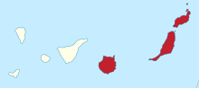
 Map of Spain with Las Palmas highlighted | |
| Coordinates: 28°20′N 14°20′W | |
| Country | Spain |
| Autonomous community | Canary Islands |
| Capital | Las Palmas de Gran Canaria |
| Area | |
| • Total | 4,066 km2 (1,570 sq mi) |
| • Rank | Ranked 46th |
| Population (2018) | |
| • Total | 1,109,175 |
| • Rank | Ranked 12th |
| • Density | 270/km2 (710/sq mi) |
| Official language(s) | Spanish |
| Parliament | Cortes Generales |


In 1927, the Province of Canary Islands was split into two provinces: Las Palmas and Santa Cruz de Tenerife. In 1982, both provinces became part of the newly founded autonomous community of the Canary Islands.
Geography
Composition
It consists of about half of the Atlantic archipelago, including the islands of Gran Canaria, Fuerteventura, and Lanzarote, as well as another six minor isles (Alegranza, Graciosa, Montaña Clara, Lobos, Roque del Este, and Roque del Oeste). Their total land area is 4,065.78 km2 (1,569.8 sq mi), representing 54.6% of the Canary Islands' total land. (The other half of the archipelago is the Province of Santa Cruz.)
General view
Its capital is the city of Las Palmas de Gran Canaria, on the island of Gran Canaria, which is also one of the capitals of the autonomous community (next to Santa Cruz de Tenerife). About 38.5% of the provincial population of 1,109,175 (2018) live in the capital. The name "Las Palmas" is generally used to refer to both the city and the province. There are 34 municipalities in the province; see List of municipalities in Las Palmas.
Las Palmas contains the Parque Nacional Timanfaya on the island of Lanzarote.
License plates in the province used to start with "GC", which referred to the island of Gran Canaria, although the same plates were also issued in Lanzarote and Fuerteventura.
Population
The historical population is given in the following chart:

Notes and references
External links
![]() Media related to Province of Las Palmas at Wikimedia Commons
Media related to Province of Las Palmas at Wikimedia Commons
- (in Spanish) Government of the Canary Islands
Municipalities in the province of Las Palmas | ||
|---|---|---|
| Gran Canaria | ||
| Lanzarote |
| |
| Fuerteventura | ||
Authority control | |
|---|---|
| General | |
| National libraries | |
| Other |
|
На других языках
[de] Provinz Las Palmas
Las Palmas ist eine spanische Provinz, bestehend aus den bewohnten kanarischen Inseln Gran Canaria, Fuerteventura, Lanzarote, La Graciosa und den unbewohnten Inseln Alegranza, Montaña Clara, Lobos, Roque del Este und Roque del Oeste. Zusammen mit der Provinz Santa Cruz de Tenerife bildet sie die Autonome Gemeinschaft Canarias. Die Provinz, die nach der Stadt Las Palmas de Gran Canaria benannt ist, ist nicht zu verwechseln mit der ebenfalls zu den Kanaren gehörenden Insel La Palma.- [en] Province of Las Palmas
[ru] Лас-Пальмас (провинция)
Лас-Пальмас (исп. Las Palmas) — островная провинция Испании, в составе автономного сообщества Канарские острова. Административный центр — Лас-Пальмас-де-Гран-Канария.Другой контент может иметь иную лицензию. Перед использованием материалов сайта WikiSort.org внимательно изучите правила лицензирования конкретных элементов наполнения сайта.
WikiSort.org - проект по пересортировке и дополнению контента Википедии