world.wikisort.org - Spain
Caldes de Montbui in Catalan or Caldas de Montbui in Spanish, is a Spanish town and municipality in the comarca of the Vallès Oriental in Catalonia. It is situated in the upper valley of the Caldes river, and the highest point of the municipality is the peak of el Farell at 816 m. It lies about 30 km from Barcelona and it part of its metropolitan area.
Caldes de Montbui
Caldas de Montbui | |
|---|---|
Municipality | |
 | |
 Flag  Coat of arms | |
 Caldes de Montbui Location in Catalonia  Caldes de Montbui Caldes de Montbui (Spain) | |
| Coordinates: 41°37′45″N 2°10′10″E | |
| Country | |
| Community | |
| Province | Barcelona |
| Comarca | Vallès Oriental |
| Government | |
| • Mayor | Isidre Pineda i Moncusí (2019) |
| Area | |
| • Total | 37.4 km2 (14.4 sq mi) |
| Elevation | 203 m (666 ft) |
| Population (2018)[2] | |
| • Total | 17,449 |
| • Density | 470/km2 (1,200/sq mi) |
| Demonym(s) | Montbuienc, montbuienca Calderí, calderina |
| Website | www |
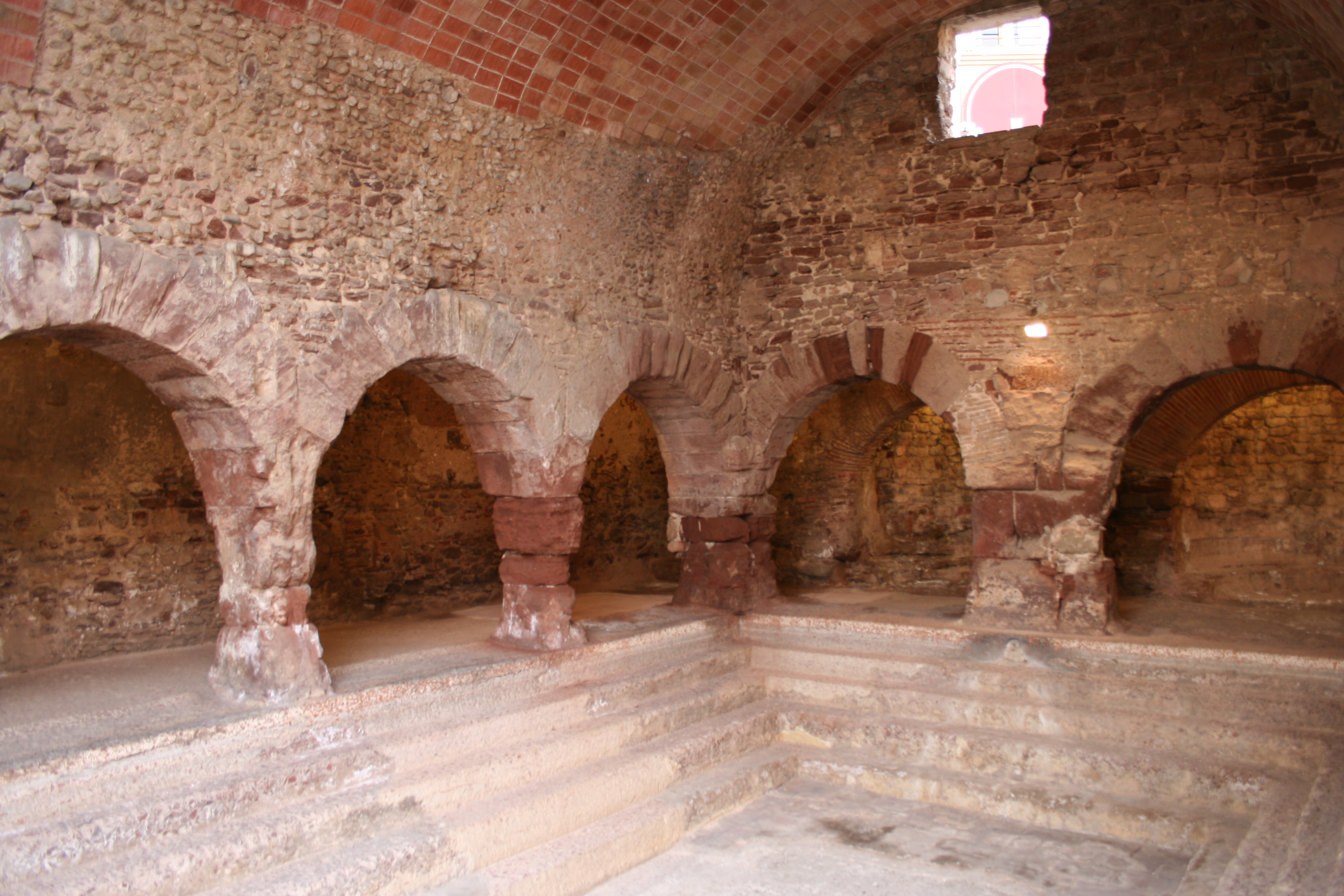
The hot springs have been exploited since Roman times, and the remnants of the Roman baths and other Roman buildings can still be seen. The source of la Font del Lleó ("Lion Springs") in the main square emerges at more than 70 °C (158 °F). The town conserves parts of its medieval fortifications and the Torre de la Presó (prison). The hermitage of la Mare de Déu del Remei dates from the sixteenth century, as does the church of Santa Maria with its baroque entrance. The roman church of Sant Sebastià de Montmajor, in the village of the same name at the extreme north-west of the municipality, is particularly well preserved.
The artist Manolo Hugué lived and worked in Caldes de Montbui, and his house has been converted into a museum displaying both his works and those of other artists. The town also has an archeological museum and the Delger museum of furniture, paintings and sculptures.
Continuing in this artistic tradition is the master landscape painter Ramon Vilanova, a native son of the city and lifetime resident.
Climate
| Climate data for Caldes de Montbui (elevation: 203 m (666 ft), data from 1941-1969) | |||||||||||||
|---|---|---|---|---|---|---|---|---|---|---|---|---|---|
| Month | Jan | Feb | Mar | Apr | May | Jun | Jul | Aug | Sep | Oct | Nov | Dec | Year |
| Average high °C (°F) | 13.3 (55.9) |
14.7 (58.5) |
17.7 (63.9) |
20.5 (68.9) |
23.7 (74.7) |
27.7 (81.9) |
30.9 (87.6) |
29.9 (85.8) |
27.4 (81.3) |
23.0 (73.4) |
17.6 (63.7) |
13.6 (56.5) |
21.7 (71.1) |
| Daily mean °C (°F) | 6.7 (44.1) |
7.8 (46.0) |
10.6 (51.1) |
13.1 (55.6) |
16.3 (61.3) |
20.2 (68.4) |
23.3 (73.9) |
23.0 (73.4) |
20.6 (69.1) |
16.2 (61.2) |
11.0 (51.8) |
7.5 (45.5) |
14.7 (58.5) |
| Average low °C (°F) | 0.0 (32.0) |
0.9 (33.6) |
3.6 (38.5) |
5.7 (42.3) |
8.9 (48.0) |
12.8 (55.0) |
15.7 (60.3) |
16.2 (61.2) |
13.8 (56.8) |
9.5 (49.1) |
4.4 (39.9) |
1.5 (34.7) |
7.8 (46.0) |
| Source: Sistema de Clasificación Bioclimática Mundial[3] | |||||||||||||
Demography
| 1900 | 1930 | 1950 | 1970 | 1986 | 2001 |
|---|---|---|---|---|---|
| 3474 | 4777 | 4729 | 8161 | 10,407 | 15,536 |
Note
- ^ Caldes de Montbui became part of the Vallès Oriental in the comarcal revision of 1990: previously it formed part of the Vallès Occidental.
References
- "El municipi en xifres: Caldes de Montbui". Statistical Institute of Catalonia. Retrieved 2015-11-23.
- Municipal Register of Spain 2018. National Statistics Institute.
- "ESP BARCELONA - CALDES DE MONTBUI".
- Panareda Clopés, Josep Maria; Rios Calvet, Jaume; Rabella Vives, Josep Maria (1989). Guia de Catalunya, Barcelona: Caixa de Catalunya. ISBN 84-87135-01-3 (Spanish). ISBN 84-87135-02-1 (Catalan).
External links
- Official website (in Catalan)
- Government data pages (in Catalan)
Places adjacent to Caldes de Montbui | ||||||||||||||||
|---|---|---|---|---|---|---|---|---|---|---|---|---|---|---|---|---|
| ||||||||||||||||
Municipalities of Vallès Oriental | ||
|---|---|---|
| ||
Municipalities in the province of Barcelona | ||
|---|---|---|
| 1,500,000+ |
|  |
| 250,000+ |
| |
| 200,000+ |
| |
| 100,000+ |
| |
| 75,000+ |
| |
| 50,000+ |
| |
| 25,000+ |
| |
| under 25,000 |
| |
Authority control | |
|---|---|
| General |
|
| National libraries | |
| Other |
|
На других языках
- [en] Caldes de Montbui
[es] Caldas de Montbuy
Caldes de Montbui[1][2] (en catalán y oficialmente Caldes de Montbui) es un municipio de Cataluña, España. Está situado en la comarca del Vallés Oriental, en la provincia de Barcelona. Se encuentra a unos 35 km al norte de Barcelona. Su población supera los 17 000 habitantes, que viven repartidos por el núcleo urbano y varias urbanizaciones, entre otras El Farell, que fue construida en una montaña a una altura de más de 800 metros. El término municipal de Caldas de Montbui comprende una extensión de 38 km².[ru] Кальдес-де-Монбуй
Кальдес-де-Монбуй (кат. Caldes de Montbui) — город и муниципалитет в Испании, входит в провинцию Барселона в составе автономного сообщества Каталония. Муниципалитет находится в составе района (комарки) Вальес-Орьенталь. Занимает площадь 38 км². Население — 17019 человек (на 2010 год). Расстояние до административного центра провинции — 30 км.Другой контент может иметь иную лицензию. Перед использованием материалов сайта WikiSort.org внимательно изучите правила лицензирования конкретных элементов наполнения сайта.
WikiSort.org - проект по пересортировке и дополнению контента Википедии