world.wikisort.org - Spain
Tavertet is a small town located above some cliffs, 900m above sea level, in the area known as Collsacabra, north of the Guilleries, in the comarca of Osona in Catalonia.
Tavertet | |
|---|---|
Municipality | |
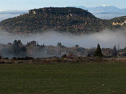
 Tavertet with the Puig de les Baumes rising over the town and the Pre-Pyrenees in the far distance | |
 Coat of arms | |
 Tavertet Location in Catalonia | |
| Coordinates: 41°59′51″N 2°25′11″E | |
| Country | |
| Community | |
| Province | Barcelona |
| Comarca | Osona |
| Government | |
| • Mayor | Lurdes Rovira Plarromaní (2015)[1] |
| Area | |
| • Total | 32.5 km2 (12.5 sq mi) |
| Elevation | 869 m (2,851 ft) |
| Population (2018)[3] | |
| • Total | 111 |
| • Density | 3.4/km2 (8.8/sq mi) |
| Website | tavertet |
Below the cliffs is Pantà de Sau, a reservoir that dammed the waters of the river Ter in the 1960s. Tavertet is nowadays a tourist-oriented town with many holiday homes, where Raimon Panikkar lived. Tavertet is linked by road BV5207 to the town of L'Esquirol, also known as Santa Maria de Corcó. There is also a minor road north of the village above the cliffs through a beech forest linking the town to Rupit.

References
- "Ajuntament de Tavertet". Generalitat of Catalonia. Retrieved 2015-11-13.
- "El municipi en xifres: Tavertet". Statistical Institute of Catalonia. Retrieved 2015-11-23.
- Municipal Register of Spain 2018. National Statistics Institute.
External links
- Government data pages (in Catalan)
- Link with the web page: Associació Amics de Tavertet (in Catalan)
На других языках
- [en] Tavertet
[es] Tavertet
Tavertet es un municipio de Cataluña, España. Perteneciente a la provincia de Barcelona, en la comarca de Osona, situado al sur de la subcomarca de Collsacabra, dentro de la zona de las Guillerías, encima de un peñasco y junto a un gran precipicio con vistas a los pantanos de Sau, Susqueda y a lo lejos las montañas del Montseny que sirve de mirador de un paisaje repleto de bosques mediterráneos.[ru] Тавертет
Тавертет (кат. Tavertet) — муниципалитет в Испании, входит в провинцию Барселона в составе автономного сообщества Каталония. Муниципалитет находится в составе района (комарки) Осона. Занимает площадь 32,56 км². Население — 148 человек (на 2010 год). Расстояние до административного центра провинции — 104 км.Текст в блоке "Читать" взят с сайта "Википедия" и доступен по лицензии Creative Commons Attribution-ShareAlike; в отдельных случаях могут действовать дополнительные условия.
Другой контент может иметь иную лицензию. Перед использованием материалов сайта WikiSort.org внимательно изучите правила лицензирования конкретных элементов наполнения сайта.
Другой контент может иметь иную лицензию. Перед использованием материалов сайта WikiSort.org внимательно изучите правила лицензирования конкретных элементов наполнения сайта.
2019-2025
WikiSort.org - проект по пересортировке и дополнению контента Википедии
WikiSort.org - проект по пересортировке и дополнению контента Википедии
