world.wikisort.org - Spain
Begur is a village and municipality in the comarca of Baix Empordà and province of Girona in Catalonia, Spain. The village itself lies some 2 kilometres (1.2 mi) from, and 200 metres (660 ft) above, the coastline of the Costa Brava, but the municipality includes several seaside resorts.[4]
Begur | |
|---|---|
Municipality | |
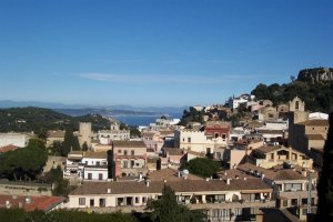 Town of Begur (with view of Bay of Estartit) | |
 Flag Coat of arms | |
 | |
| Coordinates: 41°57′N 3°13′E | |
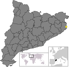
| Country | Spain |
| Autonomous community | |
| Province | Girona |
| Comarca | Baix Empordà |
| Government | |
| • mayor | Joan Manel Loureiro Vall (2015)[1] |
| Area | |
| • Total | 20.7 km2 (8.0 sq mi) |
| Elevation | 200 m (700 ft) |
| Population (2018)[3] | |
| • Total | 3,934 |
| • Density | 190/km2 (490/sq mi) |
| Postal code | 17255 |
| Website | begur |

The municipality of Begur has 3,986 inhabitants (according to the census of 2005). It is an important tourist attraction in the Baix Empordà. During the summer, the population can exceed 40,000 people.
Despite its tourist character, the village has important historical remnants that go back in early history. The castle of Begur is a good example of medieval remains. The castle was constructed in the 16th and 17th centuries.
The municipality of Begur also includes Esclanyà (with a Romanesque old part), Aiguafreda, Sa Riera, Sa Tuna, Aiguablava and Fornells. Some of the most prestigious beaches of the Costa Brava can be found here: Sa Riera, Aiguafreda, sa Tuna, Platja Fonda (although it has been almost completely destroyed by storms), Fornells and Aiguablava. The latter is also home to a Parador Hotel.
The annual festival to celebrate St. Tania takes places each November.
The village of Begur is a staging point on the GR 92 long distance footpath, which runs the length of the Mediterranean coast of Spain. Stage 7, to the north, takes an inland route to the next staging point at Torroella de Montgrí via Pals, Palau-sator, Fontanilles and Gualta. Stage 8, to the south, heads to Sa Tuna and Fornells de Mar before following the coast further south through Tamariu, Llafranc and Calella de Palafrugell to the next staging point at Palamós.[5][6][7]
Localities
The municipality includes the following localities:
- Aiguablava
- Aiguafreda
- Begur
- Esclanyà
- Fornells
- el Racó[citation needed]
- Sa Riera
- sa Tuna
References
- "Ajuntament de Begur". Generalitat of Catalonia. Retrieved 2015-11-13.
- "El municipi en xifres: Begur". Statistical Institute of Catalonia. Retrieved 2015-11-23.
- Municipal Register of Spain 2018. National Statistics Institute.
- Vissir3 (Map). Institut Cartogràfic i Geològic de Catalunya. Retrieved 14 November 2022.
- Empordà Costa Brava - Nord (Map). 1:30,000. Editorial PIOLET i Consell Comarcal del Baix Empordà. March 2012.
- Empordà Costa Brava - Sud (Map). 1:30,000. Editorial PIOLET i Consell Comarcal del Baix Empordà. March 2012.
- "GR 92: Sender de la Mediterrània" [GR 92: Mediterranian Path]. www.catalunya.com (in Catalan). Archived from the original on 7 November 2022. Retrieved 7 November 2022.
External links
- Official website
- Official website for tourists
- The international website of Begur
- Government data pages (in Catalan)
Places adjacent to Begur, Spain | |
|---|---|
Authority control | |
|---|---|
| General |
|
| National libraries | |
| Other |
|
This Province of Girona location article is a stub. You can help Wikipedia by expanding it. |
На других языках
[de] Begur
Begur (spanisch Bagur) ist eine katalanische Gemeinde in der Provinz Girona im Nordosten Spaniens. Sie liegt in der Comarca Baix Empordà.- [en] Begur, Spain
[es] Bagur
Bagur[1][2][3][4][5] (en catalán y oficialmente Begur)[6] es un municipio español de la provincia de Gerona, situado en la comarca catalana del Bajo Ampurdán.[ru] Багур
Багур (исп. Bagur, баск. Begur, кат. Begur) — муниципалитет в Испании, входит в провинцию Жирона в составе автономного сообщества Каталония. Муниципалитет находится в составе района (комарки) Баш-Эмпорда. Занимает площадь 20,71 км². Население — 4209 человек (на 2010 год).Другой контент может иметь иную лицензию. Перед использованием материалов сайта WikiSort.org внимательно изучите правила лицензирования конкретных элементов наполнения сайта.
WikiSort.org - проект по пересортировке и дополнению контента Википедии