world.wikisort.org - Russia
Solikamsk (Russian: Солика́мск, Permyak: Совкар, Sovkar, also Соликамскӧй, Sovkamsköy) is a town in Perm Krai, Russia. Modern Solikamsk is the third-largest town in the krai, with a population of 97,384 (2010 Census);[2] 102,531 (2002 Census);[8] 110,098 (1989 Census).[9]
This article may be expanded with text translated from the corresponding article in Russian. (September 2019) Click [show] for important translation instructions.
|
Solikamsk
Соликамск | |
|---|---|
Town[1] | |
 Central square in Solikamsk | |
 Flag  Coat of arms | |
Location of Solikamsk  | |
 Solikamsk Location of Solikamsk  Solikamsk Solikamsk (Perm Krai) | |
| Coordinates: 59°38′36″N 56°45′00″E | |
| Country | Russia |
| Federal subject | Perm Krai[1] |
| Founded | 1430 |
| Elevation | 150 m (490 ft) |
| Population | |
| • Total | 97,384 |
| • Estimate (2018)[3] | 93,868 (−3.6%) |
| • Rank | 174th in 2010 |
Administrative status | |
| • Subordinated to | town of krai significance of Solikamsk[1] |
| • Capital of | Solikamsky District[1], town of krai significance of Solikamsk[1] |
Municipal status | |
| • Urban okrug | Solikamsk Urban Okrug[4] |
| • Capital of | Solikamsk Urban Okrug[4], Solikamsky Municipal District[5] |
| Time zone | UTC+5 (MSK+2 |
| Postal code(s)[7] | 618540–618556 |
| OKTMO ID | 57730000001 |
History
The earliest surviving recorded mention of Solikamsk, initially as "Usolye-na-Kamskom" (Усолье на Камском) dates from 1430, in connection with the discovery and exploitation by miners and merchants, probably from Vologda, of massive salt deposits on the banks of the Usolka River.[10] The name of the town is derived from the Russian words "соль" (sol, meaning "salt") and "Кама" (Kama River, flowing through the town).
The rapid growth of Solikamsk in the 17th century was predicated on the establishment of the Babinov Road, which was the only overland route leading from European Russia to Siberia. This road started in Solikamsk. The Stroganov family operated the country's largest salt-mining facilities in Solikamsk and the surrounding area. The local saltworks were described in detail by Johann Georg Gmelin. In the mid-17th century Solikamsk also became the first centre of copper casting in Russia.
After the establishment of iron works in Yekaterinburg and Perm and the construction of a southern highway to Siberia the importance and prosperity of Solikamsk gradually declined. Until 1923, the town was the administrative center of Solikamsky Uyezd in Perm Governorate.
In November 2014 a sinkhole opened near Solikamsk because of a mining problem.[citation needed]
Coat of arms
Coat of arms was granted to Solikamsk on July 17, 1783. The arms show in the upper half the arms of Perm Governorate. The lower half shows a salt well, due to Solikamsk being the largest producer of salt and magnesium in Russia at the time.
Cultural heritage
Cultural heritage monuments in Solikamsk include a slew of old churches and several civic buildings of importance, including:
- The governor's residence (1673–1688), the oldest surviving house in the Urals.
- A two-storey wooden house dating from the early 18th century.
- Turchaninov's residence from the 1760s and 1780s.
The most important religious buildings are the following:[11]
- The Trinity Cathedral (1683–97) with five domes, three far-flung porches (of which two survive), the annex of John the Baptist (consecrated 1689) and the annex of Saint Nicholas (consecrated in 1693). Some architectural elements have no parallel anywhere in Russia.
- The octagonal Bell Tower was built in 1713. It also has no parallel in Russian architecture.
- The five-domed Church of the Lord's Epiphany (1688–95) contains a choice selection of icons from a local art museum. The tent-like belfry was rebuilt in the 1940s.
- The Church of St. John the Baptist (1721–28) with a tall belfry and a huge refectory.
- The Cathedral of the Cross (1698–1709) was rebuilt by the Soviets into a brewery. It was only in 2009 that the church's dome was restored. The palmette decoration of the walls is the earliest of its kind in Russia.
- The 5-domed Church of the Mandylion (1689–91) is situated in the former kremlin. Its altar contains another altar, which is very rare. The smaller 1-domed church of Michael the Archangel (1712–25) was intended for winter services.
- The Monastery of the Holy Trinity contains the 1-domed katholikon (built in 1698–1704) and the belfry-church of the Lord's Ascension (built in 1731–1734, mainly using funds provided by the Turchaninov industrialist family).
- The Convent of the Saviour's Transfiguration contains the 5-domed katholikon (built in 1683-92) with a tent-like belfry and a tiny church of Mary's Presentation at the Temple (consecrated in 1713).
- The large and complex Church of the Nativity and the Resurrection was built from 1714 onward. Its domes and belfry were removed by the Bolsheviks.
Other local sights include an old salt pit (in use since 1906) and the Salt Museum which occupies the buildings of the Ust-Borovaya Saltworks established in 1878.
The oldest brick building in the Urals, the Church of the Cross's Exultation (1678), is located in the former village of Verkh-Borovaya, 20 kilometers (12 mi) north of Solikamsk.
 The Epiphany Church, 1688–95
 The Trinity Cathedral, 1683–97
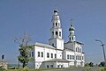 The Church of John the Baptist, 1721–28
 The governor's residence, 1673–88
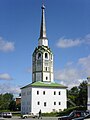 The main city bell tower, 1713


Education
Solikamsk is a home Solikamsky State Teachers' Training Institute (branch of Perm State University).
Administrative and municipal status
Within the framework of administrative divisions, Solikamsk serves as the administrative center of Solikamsky District, even though it is not a part of it.[1] As an administrative division, it is incorporated separately as the town of krai significance of Solikamsk—an administrative unit with the status equal to that of the districts.[1] As a municipal division, the town of krai significance of Solikamsk is incorporated as Solikamsk Urban Okrug.[4]
Salt production
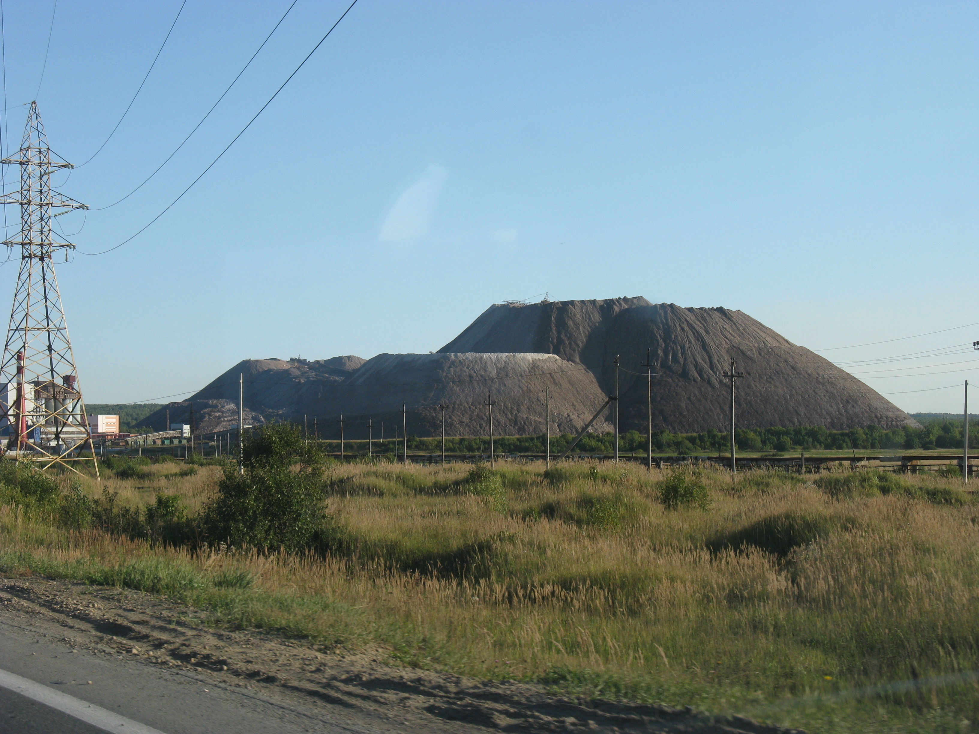
The town is famous for its production of salt; in particular, potassium chloride, which is used as a fertilizer. More than 11,000 people work in salt mining, 3,000 underground, and 7,000 above ground. It is also close to a labor camp from the Soviet times, which is now used as a museum. There is also a museum dedicated to explaining all stages of salt mining and refining.
References
Notes
- Law #416-67
- Russian Federal State Statistics Service (2011). Всероссийская перепись населения 2010 года. Том 1 [2010 All-Russian Population Census, vol. 1]. Всероссийская перепись населения 2010 года [2010 All-Russia Population Census] (in Russian). Federal State Statistics Service.
- "26. Численность постоянного населения Российской Федерации по муниципальным образованиям на 1 января 2018 года". Federal State Statistics Service. Retrieved January 23, 2019.
- Law #1772-368
- Law #1884-410
- "Об исчислении времени". Официальный интернет-портал правовой информации (in Russian). June 3, 2011. Retrieved January 19, 2019.
- Почта России. Информационно-вычислительный центр ОАСУ РПО. (Russian Post). Поиск объектов почтовой связи (Postal Objects Search) (in Russian)
- Russian Federal State Statistics Service (May 21, 2004). Численность населения России, субъектов Российской Федерации в составе федеральных округов, районов, городских поселений, сельских населённых пунктов – районных центров и сельских населённых пунктов с населением 3 тысячи и более человек [Population of Russia, Its Federal Districts, Federal Subjects, Districts, Urban Localities, Rural Localities—Administrative Centers, and Rural Localities with Population of Over 3,000] (XLS). Всероссийская перепись населения 2002 года [All-Russia Population Census of 2002] (in Russian).
- Всесоюзная перепись населения 1989 г. Численность наличного населения союзных и автономных республик, автономных областей и округов, краёв, областей, районов, городских поселений и сёл-райцентров [All Union Population Census of 1989: Present Population of Union and Autonomous Republics, Autonomous Oblasts and Okrugs, Krais, Oblasts, Districts, Urban Settlements, and Villages Serving as District Administrative Centers]. Всесоюзная перепись населения 1989 года [All-Union Population Census of 1989] (in Russian). Институт демографии Национального исследовательского университета: Высшая школа экономики [Institute of Demography at the National Research University: Higher School of Economics]. 1989 – via Demoscope Weekly.
- Богуславский, В.В.; Куксина, Е.И. (2001). Славянская энциклопедия. Киевская Русь – Московия: в 2 т. Т.2 Н-Я. ОЛМА-Пресс. p. 403. ISBN 9785224022519. Retrieved December 11, 2014.
- Brumfield, William. Solikamsk: Architectural Heritage in Photographs (Moscow: Tri Kvadrata, 2007) ISBN 978-5-94607-069-0 (in English and in Russian)
Sources
- Законодательное собрание Пермской области. Закон №416-67 от 28 февраля 1996 г. «Об административно-территориальном устройстве Пермского края», в ред. Закона №504-ПК от 9 июля 2015 г. «О внесении изменений в Закон Пермской области "Об административно-территориальном устройстве Пермского края"». Вступил в силу с момента опубликования. Опубликован: "Звезда", №38, 12 марта 1996 г. (Legislative Assembly of Perm Oblast. Law #416-67 of February 28, 1996 On the Administrative-Territorial Structure of Perm Krai, as amended by the Law #504-PK of July 9, 2015 On Amending the Law of Perm Oblast "On the Administrative-Territorial Structure of Perm Krai". Effective as of the moment of publication.).
- Законодательное собрание Пермской области. Закон №1772-368 от 10 ноября 2004 г. «Об утверждении границ и о наделении статусом муниципального образования "Город Соликамск" Пермского края», в ред. Закона №499-ПК от 16 октября 2009 г «О внесении изменений в отдельные законодательные акты Пермской области и Коми-Пермяцкого автономного округа». Вступил в силу через десять дней со дня официального опубликования. Опубликован: "Бюллетень Законодательного Собрания и администрации Пермской области", №12, I часть, 9 декабря 2004 г. (Legislative Assembly of Perm Oblast. Law #1772-368 of November 10, 2004 On Establishing the Borders and on Granting the Status to the Municipal Formation of the "Town of Solikamsk" of Perm Krai, as amended by the Law #499-PK of October 16, 2009 On Amending Various Legislative Acts of Perm Oblast and Komi-Permyak Autonomous Okrug. Effective as of the day which is ten days following the day of the official publication.).
- Законодательное собрание Пермской области. Закон №1884-410 от 9 декабря 2004 г. «Об утверждении границ и о наделении статусом муниципальных образований Соликамского района Пермского края», в ред. Закона №470-ПК от 5 мая 2015 г. «О внесении изменений в отдельные Законы Пермской области, Коми-Пермяцкого автономного округа и Пермского края». Вступил в силу через десять дней со дня официального опубликования. Опубликован: "Российская Газета", №283, 22 декабря 2004 г. (Legislative Assembly of Perm Oblast. Law #1884-410 of December 9, 2004 On Establishing the Borders and on Granting the Status to the Municipal Formations of Solikamsky District of Perm Krai, as amended by the Law #470-PK of May 5, 2015 On Amending Various Laws of Perm Oblast, Komi-Permyak Autonomous Okrug, and Perm Krai. Effective as of the day which is ten days following the day of the official publication.).
External links
- Russia Beyond the Headlines. William Brumfield. Solikamsk: Salt on the Kama
- History of the Solikamsk. Solikamsk: History
Administrative divisions of Perm Krai | |||
|---|---|---|---|
Administrative center: Perm • Rural localities | |||
| Administrative districts |
| ||
| Administrative districts of Komi-Permyak Okrug |
| ||
| Closed administrative-territorial formations | |||
| Cities and towns (all levels) | |||
| Urban-type settlements | |||
Authority control | |
|---|---|
| National libraries | |
| Other |
|
На других языках
[de] Solikamsk
Solikamsk (russisch Соликамск) ist eine der ältesten Städte der russischen Region Perm.- [en] Solikamsk
[es] Solikamsk
Solikamsk (ruso: Соликамск) es una ciudad de Rusia, la tercera más grande del krai de Perm. Está situada a orillas del Kama, a 368 km de Perm. Solikamsk tiene 97 269 habitantes en 2008. Es centro administrativo del raión homónimo. El nombre le viene dado por la contracción de sol (соль, sal) y Kama (el río Kama que pasa por la ciudad). Las ciudades más cercanas son Bereznikí y Usolie.[ru] Соликамск
Солика́мск — город в Пермском крае. Входит в состав Соликамского городского округа, являясь его административным центром. Население — ↘91 959[2] чел. (2021).Другой контент может иметь иную лицензию. Перед использованием материалов сайта WikiSort.org внимательно изучите правила лицензирования конкретных элементов наполнения сайта.
WikiSort.org - проект по пересортировке и дополнению контента Википедии