world.wikisort.org - Russia
Komi-Permyak Okrug (Russian: Ко́ми-Пермя́цкий о́круг, Komi-Permyatsky okrug; Komi-Permyak: Коми-Перем кытш, Komi-Perem kyč, or Permyakia[1][citation needed] is a territory with special status within Perm Krai, Russia. Its administrative center is the town of Kudymkar. Population: 116,157 (2010 Census);[2] 136,076 (2002 Census);[3] 159,689 (1989 Census).[4]
Komi-Permyak Okrug
Ко́ми-Пермя́цкий о́круг | |
|---|---|
Territory | |
 Flag | |
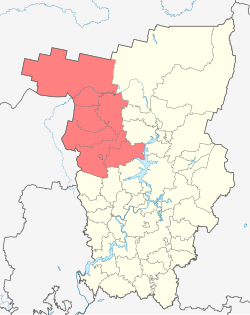 Location of Komi-Permyak Okrug within Perm Krai | |
 Komi-Permyak Okrug Location of Komi-Permyak Okrug in Russia | |
| Coordinates: 59°01′N 54°40′E | |
| Country | Russia |
| Federal subject | Perm Krai |
| Administrative center | Kudymkar |
| Area | |
| • Total | 32,770 km2 (12,650 sq mi) |
| Population (2010) | |
| • Total | 116,157 |
| • Density | 3.5/km2 (9.2/sq mi) |
It was a federal subject of Russia (an autonomous okrug) until December 1, 2005. It was known as Komi-Permyak Autonomous Okrug (Russian: Ко́ми-Пермя́цкий автоно́мный о́круг; Komi: Перым-Коми автономия кытш) at the time.
Geography
Area: 32,770 km². Location: foothills of the Ural Mountains, upper basin of the Kama River.
History
Komi-Permyak Autonomous Okrug was established on February 26, 1925. It was an administrative division for Komi-Permyaks, a branch of the Komis, within Perm Oblast. After a referendum held in October 2004, the autonomous okrug was merged with Perm Oblast to form Perm Krai. The referendum was held both in Komi-Permyak Autonomous Okrug and Perm Oblast, and the majority of citizens of both regions voted for merging.
Administrative divisions
(prior to December 1, 2005)
(after December 1, 2005)
Demographics
Vital statistics
| Average population (x 1000) | Live births | Deaths | Natural change | Crude birth rate (per 1000) | Crude death rate (per 1000) | Natural change (per 1000) | |
|---|---|---|---|---|---|---|---|
| 1970 | 210 | 3 701 | 1 993 | 1 708 | 17.6 | 9.5 | 8.1 |
| 1975 | 188 | 3 605 | 1 999 | 1 606 | 19.2 | 10.6 | 8.5 |
| 1980 | 170 | 3 259 | 2 572 | 687 | 19.2 | 15.1 | 4.0 |
| 1985 | 162 | 3 360 | 2 444 | 916 | 20.7 | 15.1 | 5.7 |
| 1990 | 146 | 2 660 | 1 931 | 729 | 18.3 | 13.3 | 5.0 |
| 1991 | 146 | 2 384 | 2 043 | 341 | 16.3 | 14.0 | 2.3 |
| 1992 | 147 | 2 267 | 2 111 | 156 | 15.4 | 14.3 | 1.1 |
| 1993 | 147 | 2 100 | 2 547 | - 447 | 14.3 | 17.3 | -3.0 |
| 1994 | 146 | 1 946 | 2 831 | - 885 | 13.3 | 19.4 | -6.1 |
| 1995 | 144 | 1 761 | 2 556 | - 795 | 12.2 | 17.7 | -5.5 |
| 1996 | 143 | 1 749 | 2 510 | - 761 | 12.2 | 17.6 | -5.3 |
| 1997 | 141 | 1 724 | 2 607 | - 883 | 12.2 | 18.4 | -6.2 |
| 1998 | 140 | 1 640 | 2 250 | - 610 | 11.7 | 16.1 | -4.4 |
| 1999 | 139 | 1 696 | 2 495 | - 799 | 12.2 | 17.9 | -5.7 |
| 2000 | 138 | 1 652 | 2 724 | -1 072 | 11.9 | 19.7 | -7.8 |
| 2001 | 137 | 1 610 | 2 700 | -1 090 | 11.7 | 19.7 | -7.9 |
| 2002 | 136 | 1 700 | 3 090 | -1 390 | 12.5 | 22.8 | -10.2 |
| 2003 | 133 | 1 675 | 3 057 | -1 382 | 12.6 | 22.9 | -10.4 |
| 2004 | 130 | 1 619 | 3 080 | -1 461 | 12.4 | 23.6 | -11.2 |
| 2005 | 127 | ||||||
| 2006 | 125 | 1 672 | 2 813 | -1 141 | 13.4 | 22.6 | -9.2 |
| 2007 | 122 | 1 845 | 2 566 | - 721 | 15.1 | 21.0 | -5.9 |
| 2008 | 120 | 2 109 | 2 523 | - 414 | 17.6 | 21.0 | -3.4 |
| 2009 | 118 | 2 144 | 2 447 | - 303 | 18.1 | 20.7 | -2.6 |
| 2010 | 116 | 2 253 | 2 497 | - 244 | 19.4 | 21.5 | -2.1 |
| 2011 | 114 | 2,072 | 2,148 | - 76 | 18.2 | 18.8 | -0.6 |
Ethnic groups
According to the 2002 Census, Komi-Permyaks make up 59.0% of the okrug's population. Other groups include Russians (38.2%), Tatars (1,100, or 0.8%), Ukrainians (706, or 0.5%), Belarusians (672, or 0.5%), and a host of other groups, each accounting for less than 0.5% of the total population.
| Ethnic group |
1926 census | 1959 census | 1970 census | 1979 census | 1989 census | 2002 census | ||||||
|---|---|---|---|---|---|---|---|---|---|---|---|---|
| Number | % | Number | % | Number | % | Number | % | Number | % | Number | % | |
| Komi-Permyaks | 117,429 | 77.0% | 125,917 | 58.0% | 123,621 | 58.3% | 105,574 | 61.4% | 95,415 | 60.2% | 80,327 | 59.0% |
| Russians | 34,814 | 22.8% | 71,381 | 32.9% | 76,340 | 36.0% | 59,760 | 34.7% | 57,272 | 36.1% | 51,946 | 38.2% |
| Others | 251 | 0.2% | 19,740 | 9.1% | 12,180 | 5.7% | 6,705 | 3.9% | 5,839 | 3.7% | 3,803 | 2.8% |
References
- Encyclopedia Encarta. Entry on Permyakia[dead link]
- Russian Federal State Statistics Service (2011). Всероссийская перепись населения 2010 года. Том 1 [2010 All-Russian Population Census, vol. 1]. Всероссийская перепись населения 2010 года [2010 All-Russia Population Census] (in Russian). Federal State Statistics Service.
- Russian Federal State Statistics Service (May 21, 2004). Численность населения России, субъектов Российской Федерации в составе федеральных округов, районов, городских поселений, сельских населённых пунктов – районных центров и сельских населённых пунктов с населением 3 тысячи и более человек [Population of Russia, Its Federal Districts, Federal Subjects, Districts, Urban Localities, Rural Localities—Administrative Centers, and Rural Localities with Population of Over 3,000] (XLS). Всероссийская перепись населения 2002 года [All-Russia Population Census of 2002] (in Russian).
- Всесоюзная перепись населения 1989 г. Численность наличного населения союзных и автономных республик, автономных областей и округов, краёв, областей, районов, городских поселений и сёл-райцентров [All Union Population Census of 1989: Present Population of Union and Autonomous Republics, Autonomous Oblasts and Okrugs, Krais, Oblasts, Districts, Urban Settlements, and Villages Serving as District Administrative Centers]. Всесоюзная перепись населения 1989 года [All-Union Population Census of 1989] (in Russian). Институт демографии Национального исследовательского университета: Высшая школа экономики [Institute of Demography at the National Research University: Higher School of Economics]. 1989 – via Demoscope Weekly.
Further reading
- Lallukka, Seppo; Liudmila Nikitina (March 2001). "Continuing with Perm, turning to Syktyvkar, or standing on one's own? The debate about the status of the Komi-Permiak Autonomous Okrug". Nationalities Papers. 29 (1): 129–151. doi:10.1080/00905990120036411.
На других языках
- [en] Komi-Permyak Okrug
[ru] Коми-Пермяцкий округ
Ко́ми-Пермя́цкий о́круг (коми-перм. Коми-Пермяцкöй округ) — административно-территориальная единица с особым статусом в составе Пермского края[3], до 1 декабря 2005 года — субъект Российской Федерации (Коми-Пермяцкий автономный округ).Другой контент может иметь иную лицензию. Перед использованием материалов сайта WikiSort.org внимательно изучите правила лицензирования конкретных элементов наполнения сайта.
WikiSort.org - проект по пересортировке и дополнению контента Википедии