world.wikisort.org - Russia
Novy Urengoy (Russian: Но́вый Уренго́й, lit: “New Urengoy”; Nenets: Едэй Уренгой, Edėy Urengoy) is a city in Yamalo-Nenets Autonomous Okrug, Russia. Population: 104,107 (2010 Census);[2] 94,456 (2002 Census);[6] 93,235 (1989 Census).[7] It is the second largest city in the autonomous okrug.
Novy Urengoy
Новый Уренгой | |
|---|---|
City[1] | |
 Counter-clockwise: Central Square, Leningradsky Avenue, Lake Molodezhnoe, Gubkina Avenue, Epiphany Cathedral | |
 Flag  Coat of arms | |
Location of Novy Urengoy  | |
 Novy Urengoy Location of Novy Urengoy 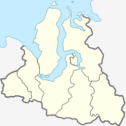 Novy Urengoy Novy Urengoy (Yamalo-Nenets Autonomous Okrug) | |
| Coordinates: 66°05′N 76°41′E | |
| Country | Russia |
| Federal subject | Yamalo-Nenets Autonomous Okrug[1] |
| Founded | 1975 |
| City status since | 1980 |
| Government | |
| • Head | Andrey Voronov |
| Elevation | 40 m (130 ft) |
| Population | |
| • Total | 104,107 |
| • Rank | 155th in 2010 |
Administrative status | |
| • Subordinated to | city of okrug significance of Novy Urengoy[1] |
| • Capital of | city of okrug significance of Novy Urengoy[1] |
Municipal status | |
| • Urban okrug | Novy Urengoy Urban Okrug[3] |
| • Capital of | Novy Urengoy Urban Okrug[3] |
| Time zone | UTC+5 (MSK+2 |
| Postal code(s)[5] | 629300–629329 |
| Dialing code(s) | +7 3494 |
| OKTMO ID | 71956000001 |
| Website | www |
History
 A USSR stamp, 1981
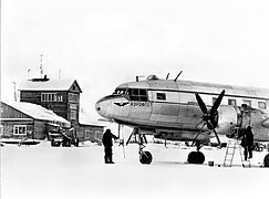
 A USSR stamp, 1983


It was founded in 1975 after the discovery of the Urengoy gas field, one of the largest in Russia.[citation needed] Town status was granted to it in 1980.[citation needed]
Administrative and municipal status
Within the framework of administrative divisions, it is incorporated as the city of okrug significance of Novy Urengoy—an administrative unit with the status equal to that of the districts.[1] As a municipal division, the city of okrug significance of Novy Urengoy is incorporated as Novy Urengoy Urban Okrug.[3]
Climate
Nature
 Sede-Yakha river
 Aurora in Novy Urengoy
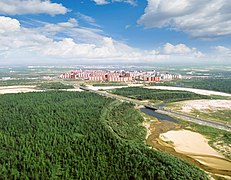 Jungle in Novy Urengoy


Novy Urengoy has a subarctic climate (Köppen climate classification Dfc). Winters are severely cold and long with average temperatures from −30 °C (−22 °F) to −22 °C (−8 °F) in January, while summers are mild and brief with average temperatures from +10 °C (50 °F) to +18 °C (64 °F) in July. Precipitation is moderate, and is somewhat higher in summer than at other times of the year.
| Climate data for Novy Urengoy | |||||||||||||
|---|---|---|---|---|---|---|---|---|---|---|---|---|---|
| Month | Jan | Feb | Mar | Apr | May | Jun | Jul | Aug | Sep | Oct | Nov | Dec | Year |
| Average high °C (°F) | −22 (−8) |
−21 (−6) |
−13 (9) |
−6 (21) |
1 (34) |
11 (52) |
18 (64) |
15 (59) |
8 (46) |
−3 (27) |
−13 (9) |
−18 (0) |
−4 (26) |
| Average low °C (°F) | −30 (−22) |
−30 (−22) |
−23 (−9) |
−17 (1) |
−7 (19) |
4 (39) |
10 (50) |
8 (46) |
2 (36) |
−9 (16) |
−20 (−4) |
−26 (−15) |
−11 (11) |
| Average precipitation mm (inches) | 27 (1.1) |
20 (0.8) |
24 (0.9) |
25 (1.0) |
34 (1.3) |
48 (1.9) |
57 (2.2) |
64 (2.5) |
61 (2.4) |
45 (1.8) |
36 (1.4) |
30 (1.2) |
471 (18.5) |
| Source: World Climate Guide[8] | |||||||||||||
Economy
A major industry of the city is oil and gas production, with one of the largest gas fields in the world in the area and substantial prospects for further exploration. The government-owned company Gazprom is the main local employer.
 Zapolyarnoye gas field
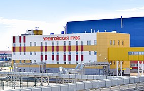 Urengoyskaya GRES a combined cycle power plant
 Urengoy gas production department


Transportation
The city is situated on the Tyumen–Novy Urengoy railway line. Traveling north from Tyumen, Novy Urengoy is the last station of significance. Noyabrsk is the previous station of significance.
Novy Urengoy is along the Salekhard–Igarka Railway, "Dead Road". Extending from Novy Urengoy to Stary Nadym is one section of the "Railway of Death" that serves as an important freight railway.
The city is served by the Novy Urengoy Airport.
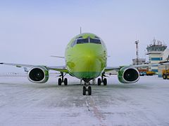 Boeing 737 at Novy Urengoy Airport
 Novy Urengoy railway station
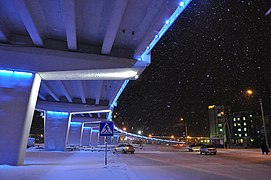 Overpass bridge in Novy Urengoy


Sports
 Snowmobile racing on water
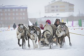 Reindeer team during the Festival of the Peoples of the North
 Fakel Novy Urengoy players at CEV Challenge Cup
 Skiing Novy Urengoy


Fakel is a men's volleyball team competing in the Russian Volleyball Super League and playing at the Gazodobytchik Sports Center. In the 2008-09 season they finished third in the competition, behind Zenit Kazan and Iskra Odintsovo.
References
Notes
- Law #42-ZAO
- Russian Federal State Statistics Service (2011). Всероссийская перепись населения 2010 года. Том 1 [2010 All-Russian Population Census, vol. 1]. Всероссийская перепись населения 2010 года [2010 All-Russia Population Census] (in Russian). Federal State Statistics Service.
- Law #102-ZAO
- "Об исчислении времени". Официальный интернет-портал правовой информации (in Russian). June 3, 2011. Retrieved January 19, 2019.
- Почта России. Информационно-вычислительный центр ОАСУ РПО. (Russian Post). Поиск объектов почтовой связи (Postal Objects Search) (in Russian)
- Russian Federal State Statistics Service (May 21, 2004). Численность населения России, субъектов Российской Федерации в составе федеральных округов, районов, городских поселений, сельских населённых пунктов – районных центров и сельских населённых пунктов с населением 3 тысячи и более человек [Population of Russia, Its Federal Districts, Federal Subjects, Districts, Urban Localities, Rural Localities—Administrative Centers, and Rural Localities with Population of Over 3,000] (XLS). Всероссийская перепись населения 2002 года [All-Russia Population Census of 2002] (in Russian).
- Всесоюзная перепись населения 1989 г. Численность наличного населения союзных и автономных республик, автономных областей и округов, краёв, областей, районов, городских поселений и сёл-райцентров [All Union Population Census of 1989: Present Population of Union and Autonomous Republics, Autonomous Oblasts and Okrugs, Krais, Oblasts, Districts, Urban Settlements, and Villages Serving as District Administrative Centers]. Всесоюзная перепись населения 1989 года [All-Union Population Census of 1989] (in Russian). Институт демографии Национального исследовательского университета: Высшая школа экономики [Institute of Demography at the National Research University: Higher School of Economics]. 1989 – via Demoscope Weekly.
- World Climate Guide - Novyy Urengoy — . Retrieved 19 November 2012.
Sources
- Государственная Дума Ямало-Ненецкого автономного округа. Закон №42-ЗАО от 6 октября 2006 г. «Об административно-территориальном устройстве Ямало-Ненецкого автономного округа», в ред. Закона №123-ЗАО от 6 декабря 2012 г. «О внесении изменений в некоторые Законы Ямало-Ненецкого автономного округа в части изменения вида населённого пункт Тазовский путём отнесения его к сельским пунктам и наделении муниципального образования посёлок Тазовский статусом сельского поселения». Вступил в силу по истечении десяти дней со дня официального опубликования. Опубликован: "Красный Север", №119, 13 октября 2006 г. (State Duma of Yamalo-Nenets Autonomous Okrug. Law #42-ZAO of October 6, 2006 On the Administrative-Territorial Structure of Yamalo-Nenets Autonomous Okrug, as amended by the Law #123-ZAO of December 6, 2012 On Amending Various Laws of Yamalo-Nenets Autonomous Okrug Due to Changing the Status of the Inhabited Locality of Tazovsky to a Rural Locality and on Granting the Municipal Formation of the Settlement of Tazovsky the Status of a Rural Settlement. Effective as of the day upon expiration of ten days from the official publication date.).
- Государственная Дума Ямало-Ненецкого автономного округа. Закон №102-ЗАО от 16 декабря 2004 г. «О наделении статусом, определении административного центра и установлении границ муниципального образования город Новый Уренгой», в ред. Закона №102-ЗАО от 31 октября 2012 г. «О внесении изменения в Закон Ямало-Ненецкого автономного округа "О наделении статусом, определении административного центра и установлении границ муниципального образования город Новый Уренгой"». Вступил в силу со дня официального опубликования. Опубликован: "Красный Север", спецвыпуск №4, 27 января 2005 г. (State Duma of Yamalo-Nenets Autonomous Okrug. Law #102-ZAO of December 16, 2004 On Granting the Status, Determining the Administrative Center, and Establishing the Borders of the Municipal Formation of the City of Novy Urengoy, as amended by the Law #102-ZAO of October 31, 2012 On Amending the Law of Yamalo-Nenets Autonomous Okrug "On Granting the Status, Determining the Administrative Center, and Establishing the Borders of the Municipal Formation of the City of Novy Urengoy". Effective as of the day of the official publication.).
External links
- Official website of Novy Urengoy (in Russian)
- Official website of Yamalo-Nenets Autonomous Okrug: Novy Urengoy (in Russian)
- PRO New Urengoy - city portal (in Russian)
Administrative divisions of Yamalo-Nenets Autonomous Okrug | |||
|---|---|---|---|
Administrative center: Salekhard • Rural localities | |||
| Districts | |||
| Cities and towns | |||
| Urban-type settlements |
| ||
Authority control | |
|---|---|
| General |
|
| National libraries | |
| Other |
|
На других языках
[de] Nowy Urengoi
Nowy Urengoi (russisch Но́вый Уренго́й) ist eine Großstadt in Russland mit 104.107 Einwohnern (Stand 14. Oktober 2010).[1] Sie liegt im Autonomen Kreis der Jamal-Nenzen im nördlichen Westsibirien am Pur-Zufluss Jewo-Jacha, etwa 450 km östlich der Kreishauptstadt Salechard. Die nächstgelegene Stadt ist Tarko-Sale, die sich 139 km südlich von Nowy Urengoi befindet.- [en] Novy Urengoy
[es] Novi Urengói
Novi Urengói (en ruso: Новый Уренгой) es una ciudad situada en el distrito autónomo de Yamalia-Nenetsia (óblast de Tiumén), en el extremo norte de la Federación Rusa. Se encuentra a 450 km al este de Salejard, la capital del distrito. Está a orillas del río Yevo-yaja, un afluente del Pur. La ciudad más cercana es Tarko-Salé a 139 km al sur. Su población ascendía a 118 378 habitantes en 2008.[ru] Новый Уренгой
Но́вый Уренго́й — город в России, в Ямало-Ненецком автономном округе, (в разговорной речи и сокр. — НУР), первый по величине город округа, один из немногих российских региональных городов, превосходящих административный центр своего субъекта федерации (в данном случае Салехард) как по численности населения, так и по промышленному развитию[2]. Город возник в ходе разработки Тюменской нефти и расположен на берегу реки Евояхи, притоке Пура в 579 км восточнее Салехарда. Реки Тамчаруяха и Седэяха протекают через город[3] и делят его на две части — Северную, центральную и Южную. Территорию городского округа с запада окружает Надымский район, а с востока Пуровский район.Другой контент может иметь иную лицензию. Перед использованием материалов сайта WikiSort.org внимательно изучите правила лицензирования конкретных элементов наполнения сайта.
WikiSort.org - проект по пересортировке и дополнению контента Википедии