world.wikisort.org - Russia
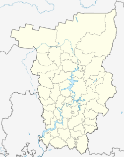
Biser (Russian: Бисер), is a urban locality (an urban-type settlement) in Gornozavodsky District, Perm Krai, Russia. Population: 1,323 (2010 Census);[1]
Biser
Бисер | |
|---|---|
Urban-type settlement | |
Location of Biser  | |
 Biser Location of Biser  Biser Biser (Perm Krai) | |
| Coordinates: 58°31′N 58°51′E | |
| Country | Russia |
| Federal subject | Perm Krai |
| Administrative district | Gornozavodsky District |
| Population | |
| • Total | 1,323 |
| • Estimate (2018)[2] | 638 (−51.8%) |
| Time zone | UTC+5 (MSK+2 |
| Postal code(s)[4] | |
| OKTMO ID | 57614401051 |
History
The settlement was formed at Bisersky Zavod station (now Biser station) of Gornozavodskaya railway opened in 1878. The station was built 12 km to the north of Biser ironworks.[5]
Settlement of town type since December 20, 1991. Biser was the centre of Biser town council (from 1991 until January 2006).
Transportation
Biser lies on the railway from Solikamsk to Yekaterinburg.[6] On 11 February 1924 the station was renamed Yemshanovo in honor of Alexander Ivanovich Yemshanov, the manager of the Perm Railway and a former (1920-21) People's Commissar of Communications (i.e. Transport) of the RSFSR. The name reverted to Biser after Yemshanov was shot in the Great Purge on 26 November 1937.
Climate
Biser has a subarctic climate (Köppen climate classification Dfc), with very cold winters and mild summers. Precipitation is quite high, and is heavier in summer and autumn than at other times of the year.
| Climate data for Biser | |||||||||||||
|---|---|---|---|---|---|---|---|---|---|---|---|---|---|
| Month | Jan | Feb | Mar | Apr | May | Jun | Jul | Aug | Sep | Oct | Nov | Dec | Year |
| Record high °C (°F) | 1.5 (34.7) |
5.6 (42.1) |
15.0 (59.0) |
24.1 (75.4) |
32.0 (89.6) |
34.5 (94.1) |
32.9 (91.2) |
33.4 (92.1) |
27.2 (81.0) |
20.2 (68.4) |
7.2 (45.0) |
2.5 (36.5) |
34.5 (94.1) |
| Average high °C (°F) | −13.1 (8.4) |
−10.8 (12.6) |
−3.3 (26.1) |
5.7 (42.3) |
13.3 (55.9) |
19.3 (66.7) |
21.2 (70.2) |
18.0 (64.4) |
11.2 (52.2) |
2.1 (35.8) |
−6.1 (21.0) |
−11.1 (12.0) |
3.9 (39.0) |
| Daily mean °C (°F) | −16.9 (1.6) |
−14.8 (5.4) |
−8.3 (17.1) |
0.7 (33.3) |
7.5 (45.5) |
13.6 (56.5) |
15.9 (60.6) |
13.0 (55.4) |
7.0 (44.6) |
−0.9 (30.4) |
−9.1 (15.6) |
−14.8 (5.4) |
−0.6 (31.0) |
| Average low °C (°F) | −20.4 (−4.7) |
−18.7 (−1.7) |
−12.7 (9.1) |
−4.2 (24.4) |
2.0 (35.6) |
7.8 (46.0) |
10.4 (50.7) |
8.3 (46.9) |
3.4 (38.1) |
−3.6 (25.5) |
−11.9 (10.6) |
−17.9 (−0.2) |
−4.8 (23.4) |
| Record low °C (°F) | −49.8 (−57.6) |
−43.3 (−45.9) |
−36.9 (−34.4) |
−26.0 (−14.8) |
−15.9 (3.4) |
−4.8 (23.4) |
−0.9 (30.4) |
−2.8 (27.0) |
−11.2 (11.8) |
−31.6 (−24.9) |
−38.4 (−37.1) |
−52.5 (−62.5) |
−52.5 (−62.5) |
| Average precipitation mm (inches) | 53.2 (2.09) |
37.4 (1.47) |
44.0 (1.73) |
46.1 (1.81) |
64.9 (2.56) |
85.3 (3.36) |
101.2 (3.98) |
94.2 (3.71) |
88.5 (3.48) |
81.1 (3.19) |
68.3 (2.69) |
62.1 (2.44) |
826.3 (32.51) |
| Average precipitation days (≥ 0.1 mm) | 16.7 | 12.5 | 18.6 | 16.3 | 7.6 | 11.3 | 10.0 | 9.4 | 14.7 | 21.0 | 23.3 | 19.3 | 180.7 |
| Average relative humidity (%) | 80.8 | 78.1 | 74.3 | 66.5 | 55.2 | 67.4 | 68.3 | 73.8 | 81.0 | 85.0 | 85.8 | 83.3 | 75.0 |
| Mean monthly sunshine hours | 46 | 88 | 160 | 198 | 268 | 287 | 291 | 217 | 137 | 66 | 44 | 26 | 1,828 |
| Source 1: climatebase.ru[7] | |||||||||||||
| Source 2: NOAA (sun only, 1961-1990)[8] | |||||||||||||
References
- Russian Federal State Statistics Service (2011). Всероссийская перепись населения 2010 года. Том 1 [2010 All-Russian Population Census, vol. 1]. Всероссийская перепись населения 2010 года [2010 All-Russia Population Census] (in Russian). Federal State Statistics Service.
- "26. Численность постоянного населения Российской Федерации по муниципальным образованиям на 1 января 2018 года". Federal State Statistics Service. Retrieved 23 January 2019.
- "Об исчислении времени". Официальный интернет-портал правовой информации (in Russian). 3 June 2011. Retrieved 19 January 2019.
- Почта России. Информационно-вычислительный центр ОАСУ РПО. (Russian Post). Поиск объектов почтовой связи (Postal Objects Search) (in Russian)
- "Уральская железная дорога". www.archive.perm.ru. Retrieved 2021-10-25.
- "Biser station railway station". Retrieved 21 January 2013.
- "Biser, Perm, Russia". Climatebase.ru. Retrieved 21 January 2013.
- "Climate Normals for Biser". National Oceanic and Atmospheric Administration. Retrieved 18 January 2013.
На других языках
- [en] Biser, Russia
[ru] Бисер (Пермский край)
Би́сер — посёлок городского типа (до 1991 года — посёлок станции или станция) в Пермском крае России. Входит в Горнозаводский район (городской округ).Другой контент может иметь иную лицензию. Перед использованием материалов сайта WikiSort.org внимательно изучите правила лицензирования конкретных элементов наполнения сайта.
WikiSort.org - проект по пересортировке и дополнению контента Википедии