world.wikisort.org - Norway
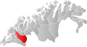
Målselv (Northern Sami: Málatvuomi suohkan) is a municipality in Troms og Finnmark county, Norway. The administrative centre of the municipality is the village of Moen. The main commercial centre of the municipality is the Bardufoss area (including Andselv, Andslimoen, and Heggelia). Other villages in the municipality include Alappmoen, Fossmoen, Holmen, and Skjold. Besides bordering Sweden to the east and the ocean (Malangen fjord) to the northwest, it borders the municipalities of Balsfjord, Storfjord, Bardu, Sørreisa, and Lenvik.
Målselv kommune
Málatvuomi suohkan | |
|---|---|
Municipality | |
 View of the mountain Istind on the Bardu-Målselv border | |
 Flag  Coat of arms  Troms og Finnmark within Norway | |
 Målselv within Troms og Finnmark | |
| Coordinates: 68°58′30″N 19°03′52″E | |
| Country | Norway |
| County | Troms og Finnmark |
| District | Midt-Troms |
| Established | 1848 |
| • Preceded by | Lenviken Municipality |
| Administrative centre | Moen |
| Government | |
| • Mayor (2019) | Bengt-Magne Luneng (Sp) |
| Area | |
| • Total | 3,324.45 km2 (1,283.58 sq mi) |
| • Land | 3,202.56 km2 (1,236.52 sq mi) |
| • Water | 121.89 km2 (47.06 sq mi) 3.7% |
| • Rank | #11 in Norway |
| Population (2022) | |
| • Total | 6,599 |
| • Rank | #149 in Norway |
| • Density | 2.1/km2 (5/sq mi) |
| • Change (10 years) | |
| Demonym | Målselvdøl[1] |
| Official language | |
| • Norwegian form | Neutral |
| Time zone | UTC+01:00 (CET) |
| • Summer (DST) | UTC+02:00 (CEST) |
| ISO 3166 code | NO-5418 |
| Website | Official website |
The 3,326-square-kilometre (1,284 sq mi) municipality is the 11th largest by area out of the 356 municipalities in Norway. Målselv is the 149th most populous municipality in Norway with a population of 6,599. The municipality's population density is 2.1 inhabitants per square kilometre (5.4/sq mi) and its population has increased by 0% over the previous 10-year period.[3][4]
General information
The municipality of Maalselven was established in 1848 when it was separated from the large Lenviken Municipality. The initial population of Maalselven was 2,616. In 1891, some parts of the Maalsnes area (population: 30) were transferred to neighboring Malangen municipality. On 1 January 1904, an area with 5 inhabitants was transferred from Balsfjord Municipality to Maalselven. The spelling of the name was changed to Målselv in 1918. On 1 July 1925, the eastern district of the municipality was separated from Målselv to form the new Øverbygd municipality. This left Målselv with 3,531 residents.[5]
During the 1960s, there were many municipal mergers across Norway due to the work of the Schei Committee. On 1 January 1964, the municipality of Øverbygd (population: 1,232), the municipality of Målselv (population: 5,584), the Naveren and Målsnes areas of Malangen (population: 118), and the "Skogli ved Heia" farm in Balsfjord (population: 2) were all merged to form a new, larger municipality of Målselv with a new population of 6,936. On 1 January 1966, the Sørelvmo/Aursfjordbotn area (population: 131) was transferred from Balsfjord to Målselv. Then on 1 January 1972, the "Blomli i Fagerfjell" area of Målselv (population: 63) was transferred to Lenvik Municipality.[5]
On 1 January 2020, the municipality became part of the newly formed Troms og Finnmark county. Previously, it had been part of the old Troms county.[6]
Name
The municipality is named after the river Målselva. The first element is the genitive case of the old uncompounded name of the Malangen fjord: Malr and the last element is the finite form of elv which means "river". The old name of the fjord is identical with the Old Norse word malr which means "bag" or "sack" (referring to the shape of the fjord). Prior to 1918, the name was written "Maalselven".[7]
Coat of arms
The coat of arms was granted on 1 February 1985. The arms show a white river on a green background. They are a canting that represent the Målselva river which runs through the municipality.[8]
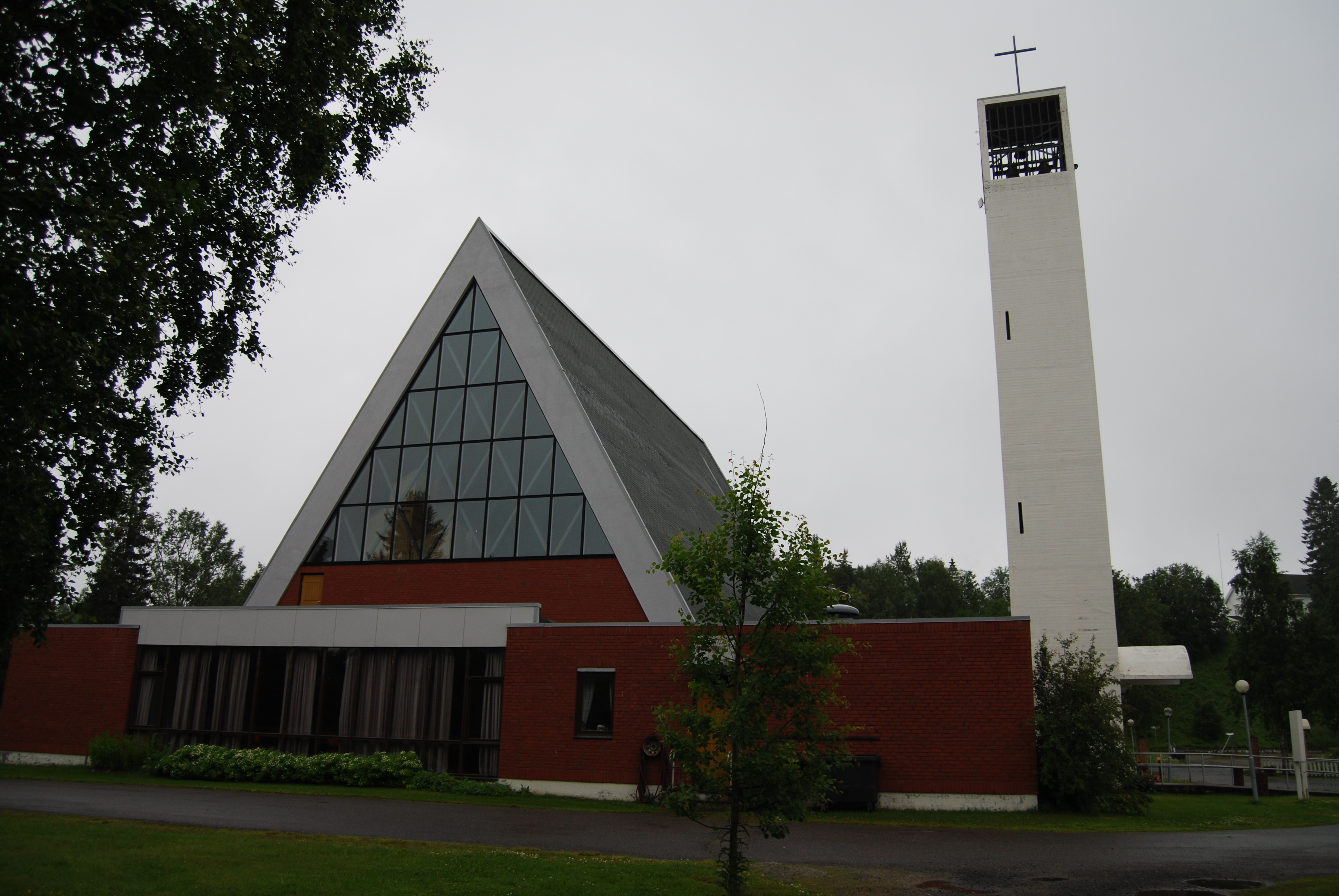
Churches
The Church of Norway has two parishes (sokn) within the municipality of Målselv. It is part of the Indre Troms prosti (deanery) in the Diocese of Nord-Hålogaland.
| Parish (sokn) | Church name | Location of the church | Year built |
|---|---|---|---|
| Målselv | Målselv Church | Målselv | 1978 |
| Øverbygd | Øverbygd Church | Øverbygd | 1867 |
| Kirkesnesmoen Chapel | Kirkesnesmoen | 1977 |
Geography
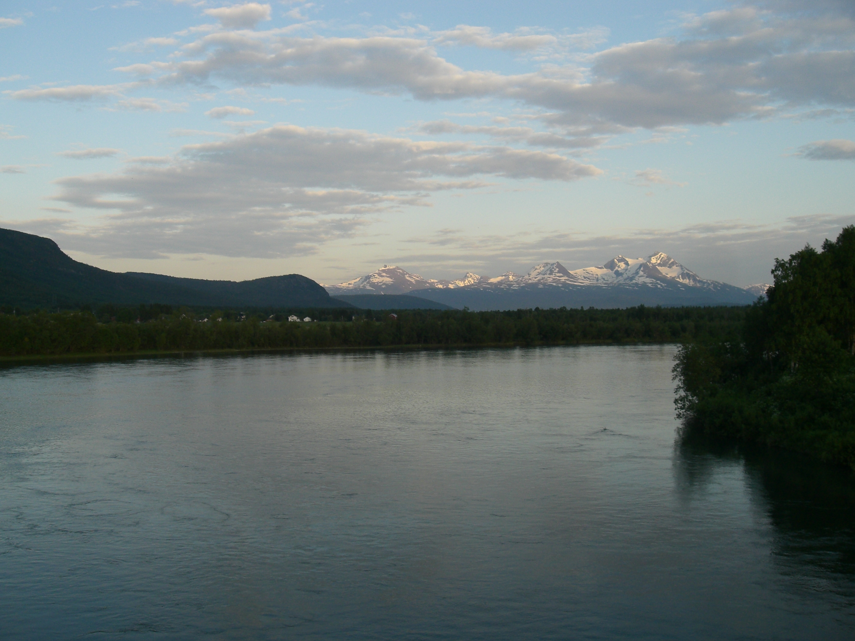
Målselv was settled by farmers from southern Norway, especially Østerdalen from 1788 and onwards. They were attracted by the vast forests and areas of fertile land in the broad Målselvdalen. The valley and municipality take their name from the river Målselva. The river is well known for its salmon, and forms the Målselv waterfall (Norwegian: Målselvfossen), which has been selected as Norway's national waterfall. The Målselva empties into the Malangen fjord north of Olsborg. There are several mountains in the municipality: Njunis (1,713 m or 5,620 ft) is the highest and Istind is popular among hikers. There are many lakes such as Andsvatnet, Finnfjordvatnet, Rostojávri, Lille Rostavatn, and Takvatnet. One of the rarest orchids in Europe, Lysiella oligantha (Norwegian: Sibirnattfiol), is found in Målselv. Øvre Dividal National Park (740 km2 or 290 sq mi) is located in the easternmost part of Målselv, near the border with Sweden.
Media gallery
 Målselv kirke
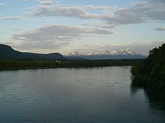 Målselv river and valley
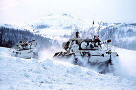 The Norwegian Armed Forces has a long history in Målselv
 Heggelia in Målselv
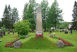 Memorial for those killed during WW2 in Målselv
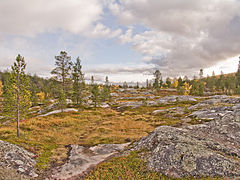 Øvre Dividal national park
 Blåtindan mountain


Climate
Målselv has a boreal climate (Köppen climate classification: Dfc) with cold winters, and with spring and early summer as the driest season.
Målselv is fairly sheltered from the coastal weather, and has a somewhat inland climate. The all-time high 33.5 °C (92.3 °F) is from July 2018, while the warmest month on record at Bardufoss Airport is July 2014 with average daily high 23.4 °C (74.1 °F) and mean 17.7 °C (63.9 °F). The all-time low −38.1 °C (−36.6 °F) was recorded December 1978. The coldest month recorded is February 1966 with mean −18.1 °C (−0.6 °F) and average daily low −23 °C (−9 °F). Mean annual precipitation is 703 millimetres (27.7 in) at Bardufoss and only 282 millimetres (11.1 in) in the Divi valley, which sits at 282 m (925 ft) above sea level.[9]
There is on average 93 days each winter with daily low −10 °C (14 °F) or colder, and 28 days with low −20 °C (−4 °F) or colder. The winter season sees on average 68 days with at least 50 centimetres (20 in) snow cover on the ground, 126 days with at least 25 centimetres (9.8 in) snow cover, and 179 days with at least 5 centimetres (2.0 in) snow cover. In the warm season there is on average 116 days each year when the daily average high reaches 10 °C (50 °F) or warmer and 22 days with daily average high above 20 °C (68 °F). Precipitation is fairly moderate, there is on average 75 days per year with at least 3 millimetres (0.12 in) precipitation and 15 days per year with at least 10 millimetres (0.39 in) precipitation. This is based on data from Met.no with 1971–2000 as base period.[10] The average date for first overnight freeze (below 0 °C (32 °F)) in autumn is 4 September (1981-2010 average).[11]
| Climate data for Bardufoss 1991-2020 (76 m, extremes 1940-2020) | |||||||||||||
|---|---|---|---|---|---|---|---|---|---|---|---|---|---|
| Month | Jan | Feb | Mar | Apr | May | Jun | Jul | Aug | Sep | Oct | Nov | Dec | Year |
| Record high °C (°F) | 8.9 (48.0) |
9 (48) |
11.9 (53.4) |
17.5 (63.5) |
27.7 (81.9) |
31.1 (88.0) |
33.5 (92.3) |
32.2 (90.0) |
23.7 (74.7) |
20 (68) |
12.2 (54.0) |
10.1 (50.2) |
33.5 (92.3) |
| Average high °C (°F) | −6 (21) |
−5 (23) |
0 (32) |
5 (41) |
11 (52) |
14 (57) |
18 (64) |
17 (63) |
12 (54) |
5 (41) |
−1 (30) |
−4 (25) |
6 (42) |
| Daily mean °C (°F) | −9.7 (14.5) |
−9.1 (15.6) |
−5.1 (22.8) |
0.6 (33.1) |
6 (43) |
10.7 (51.3) |
13.7 (56.7) |
12.3 (54.1) |
7.4 (45.3) |
0.8 (33.4) |
−4.7 (23.5) |
−7.8 (18.0) |
1.3 (34.3) |
| Average low °C (°F) | −13 (9) |
−12 (10) |
−9 (16) |
−3 (27) |
2 (36) |
7 (45) |
10 (50) |
8 (46) |
4 (39) |
−1 (30) |
−7 (19) |
−10 (14) |
−2 (28) |
| Record low °C (°F) | −36.2 (−33.2) |
−34.8 (−30.6) |
−31.7 (−25.1) |
−25.1 (−13.2) |
−11.2 (11.8) |
−2 (28) |
0.6 (33.1) |
−4 (25) |
−12.4 (9.7) |
−25.5 (−13.9) |
−29.8 (−21.6) |
−38.1 (−36.6) |
−38.1 (−36.6) |
| Average precipitation mm (inches) | 68.9 (2.71) |
58.5 (2.30) |
62.4 (2.46) |
34.2 (1.35) |
34.4 (1.35) |
45.5 (1.79) |
62.7 (2.47) |
64.6 (2.54) |
71.4 (2.81) |
72 (2.8) |
56.4 (2.22) |
72.5 (2.85) |
703.5 (27.65) |
| Source 1: Weatheronline (avg high/low)[12] | |||||||||||||
| Source 2: yr.no/met.no/eklima (mean, precipitation, extremes)[13] | |||||||||||||
| Climate data for Bardufoss 1961–90 (76 m) | |||||||||||||
|---|---|---|---|---|---|---|---|---|---|---|---|---|---|
| Month | Jan | Feb | Mar | Apr | May | Jun | Jul | Aug | Sep | Oct | Nov | Dec | Year |
| Average high °C (°F) | −5.9 (21.4) |
−4.5 (23.9) |
−0.4 (31.3) |
3.8 (38.8) |
9.3 (48.7) |
14.8 (58.6) |
17.4 (63.3) |
15.8 (60.4) |
10.5 (50.9) |
4.3 (39.7) |
−1.7 (28.9) |
−4.7 (23.5) |
4.9 (40.8) |
| Daily mean °C (°F) | −10.4 (13.3) |
−8.9 (16.0) |
−5.4 (22.3) |
−0.2 (31.6) |
5.6 (42.1) |
10.5 (50.9) |
13.0 (55.4) |
11.5 (52.7) |
6.3 (43.3) |
0.9 (33.6) |
−5.5 (22.1) |
−8.9 (16.0) |
0.7 (33.3) |
| Average low °C (°F) | −15.1 (4.8) |
−13.7 (7.3) |
−10.9 (12.4) |
−5.1 (22.8) |
1.1 (34.0) |
6.2 (43.2) |
8.8 (47.8) |
6.9 (44.4) |
2.5 (36.5) |
−2.5 (27.5) |
−9.4 (15.1) |
−13.6 (7.5) |
−3.7 (25.3) |
| Average precipitation mm (inches) | 66 (2.6) |
58 (2.3) |
40 (1.6) |
33 (1.3) |
24 (0.9) |
38 (1.5) |
57 (2.2) |
63 (2.5) |
64 (2.5) |
77 (3.0) |
64 (2.5) |
68 (2.7) |
652 (25.7) |
| Average precipitation days (≥ 1 mm) | 11.2 | 11.4 | 9.3 | 7.8 | 6.8 | 8.9 | 11.7 | 12.7 | 12.9 | 13.7 | 12.0 | 12.5 | 130.9 |
| Source: Norwegian Meteorological Institute[14] | |||||||||||||
Government
All municipalities in Norway, including Målselv, are responsible for primary education (through 10th grade), outpatient health services, senior citizen services, unemployment and other social services, zoning, economic development, and municipal roads. The municipality is governed by a municipal council of elected representatives, which in turn elect a mayor.[15] The municipality falls under the Senja District Court and the Hålogaland Court of Appeal.
Municipal council
The municipal council (Kommunestyre) of Målselv is made up of 23 representatives that are elected to four-year terms. The party breakdown of the council is as follows:
| Party Name (in Norwegian) | Number of representatives | |
|---|---|---|
| Labour Party (Arbeiderpartiet) | 7 | |
| Progress Party (Fremskrittspartiet) | 1 | |
| Conservative Party (Høyre) | 2 | |
| Red Party (Rødt) | 1 | |
| Centre Party (Senterpartiet) | 10 | |
| Socialist Left Party (Sosialistisk Venstreparti) | 1 | |
| Liberal Party (Venstre) | 1 | |
| Total number of members: | 23 | |
| Party Name (in Norwegian) | Number of representatives | |
|---|---|---|
| Labour Party (Arbeiderpartiet) | 11 | |
| Progress Party (Fremskrittspartiet) | 2 | |
| Conservative Party (Høyre) | 4 | |
| Centre Party (Senterpartiet) | 4 | |
| Socialist Left Party (Sosialistisk Venstreparti) | 1 | |
| Liberal Party (Venstre) | 3 | |
| Total number of members: | 25 | |
| Party Name (in Norwegian) | Number of representatives | |
|---|---|---|
| Labour Party (Arbeiderpartiet) | 10 | |
| Progress Party (Fremskrittspartiet) | 3 | |
| Conservative Party (Høyre) | 5 | |
| Centre Party (Senterpartiet) | 3 | |
| Socialist Left Party (Sosialistisk Venstreparti) | 1 | |
| Liberal Party (Venstre) | 3 | |
| Total number of members: | 25 | |
| Party Name (in Norwegian) | Number of representatives | |
|---|---|---|
| Labour Party (Arbeiderpartiet) | 13 | |
| Progress Party (Fremskrittspartiet) | 5 | |
| Conservative Party (Høyre) | 3 | |
| Centre Party (Senterpartiet) | 4 | |
| Liberal Party (Venstre) | 2 | |
| Joint list of the Red Electoral Alliance (Rød Valgallianse) and the Socialist Left Party (Sosialistisk Venstreparti) | 2 | |
| Total number of members: | 29 | |
| Party Name (in Norwegian) | Number of representatives | |
|---|---|---|
| Labour Party (Arbeiderpartiet) | 11 | |
| The Democrats (Demokratene) | 1 | |
| Progress Party (Fremskrittspartiet) | 3 | |
| Conservative Party (Høyre) | 4 | |
| Centre Party (Senterpartiet) | 4 | |
| Liberal Party (Venstre) | 3 | |
| Joint list of the Red Electoral Alliance (Rød Valgallianse) and the Socialist Left Party (Sosialistisk Venstreparti) | 3 | |
| Total number of members: | 29 | |
| Party Name (in Norwegian) | Number of representatives | |
|---|---|---|
| Labour Party (Arbeiderpartiet) | 8 | |
| Progress Party (Fremskrittspartiet) | 3 | |
| Conservative Party (Høyre) | 6 | |
| Red Electoral Alliance (Rød Valgallianse) | 1 | |
| Centre Party (Senterpartiet) | 6 | |
| Liberal Party (Venstre) | 5 | |
| Total number of members: | 29 | |
| Party Name (in Norwegian) | Number of representatives | |
|---|---|---|
| Labour Party (Arbeiderpartiet) | 6 | |
| Progress Party (Fremskrittspartiet) | 1 | |
| Conservative Party (Høyre) | 5 | |
| Centre Party (Senterpartiet) | 6 | |
| Socialist Left Party (Sosialistisk Venstreparti) | 2 | |
| Liberal Party (Venstre) | 9 | |
| Total number of members: | 29 | |
| Party Name (in Norwegian) | Number of representatives | |
|---|---|---|
| Labour Party (Arbeiderpartiet) | 6 | |
| Conservative Party (Høyre) | 5 | |
| Centre Party (Senterpartiet) | 4 | |
| Socialist Left Party (Sosialistisk Venstreparti) | 2 | |
| Liberal Party (Venstre) | 8 | |
| Total number of members: | 25 | |
| Party Name (in Norwegian) | Number of representatives | |
|---|---|---|
| Labour Party (Arbeiderpartiet) | 15 | |
| Conservative Party (Høyre) | 10 | |
| Christian Democratic Party (Kristelig Folkeparti) | 2 | |
| Centre Party (Senterpartiet) | 6 | |
| Socialist Left Party (Sosialistisk Venstreparti) | 2 | |
| Liberal Party (Venstre) | 2 | |
| Total number of members: | 37 | |
| Party Name (in Norwegian) | Number of representatives | |
|---|---|---|
| Labour Party (Arbeiderpartiet) | 15 | |
| Conservative Party (Høyre) | 13 | |
| Christian Democratic Party (Kristelig Folkeparti) | 1 | |
| Centre Party (Senterpartiet) | 4 | |
| Socialist Left Party (Sosialistisk Venstreparti) | 2 | |
| Liberal Party (Venstre) | 2 | |
| Total number of members: | 37 | |
| Party Name (in Norwegian) | Number of representatives | |
|---|---|---|
| Labour Party (Arbeiderpartiet) | 13 | |
| Conservative Party (Høyre) | 12 | |
| Christian Democratic Party (Kristelig Folkeparti) | 2 | |
| Centre Party (Senterpartiet) | 6 | |
| Socialist Left Party (Sosialistisk Venstreparti) | 2 | |
| Liberal Party (Venstre) | 2 | |
| Total number of members: | 37 | |
| Party Name (in Norwegian) | Number of representatives | |
|---|---|---|
| Labour Party (Arbeiderpartiet) | 16 | |
| Conservative Party (Høyre) | 9 | |
| Christian Democratic Party (Kristelig Folkeparti) | 2 | |
| Centre Party (Senterpartiet) | 7 | |
| Socialist Left Party (Sosialistisk Venstreparti) | 1 | |
| Liberal Party (Venstre) | 2 | |
| Total number of members: | 37 | |
| Party Name (in Norwegian) | Number of representatives | |
|---|---|---|
| Labour Party (Arbeiderpartiet) | 17 | |
| Conservative Party (Høyre) | 7 | |
| Centre Party (Senterpartiet) | 10 | |
| Liberal Party (Venstre) | 3 | |
| Total number of members: | 37 | |
| Party Name (in Norwegian) | Number of representatives | |
|---|---|---|
| Labour Party (Arbeiderpartiet) | 18 | |
| Conservative Party (Høyre) | 8 | |
| Centre Party (Senterpartiet) | 8 | |
| Liberal Party (Venstre) | 3 | |
| Total number of members: | 37 | |
| Party Name (in Norwegian) | Number of representatives | |
|---|---|---|
| Labour Party (Arbeiderpartiet) | 18 | |
| Conservative Party (Høyre) | 7 | |
| Centre Party (Senterpartiet) | 8 | |
| Liberal Party (Venstre) | 3 | |
| Local List(s) (Lokale lister) | 1 | |
| Total number of members: | 37 | |
| Party Name (in Norwegian) | Number of representatives | |
|---|---|---|
| Labour Party (Arbeiderpartiet) | 9 | |
| Local List(s) (Lokale lister) | 18 | |
| Total number of members: | 27 | |
| Party Name (in Norwegian) | Number of representatives | |
|---|---|---|
| Labour Party (Arbeiderpartiet) | 12 | |
| Local List(s) (Lokale lister) | 15 | |
| Total number of members: | 27 | |
| Party Name (in Norwegian) | Number of representatives | |
|---|---|---|
| Labour Party (Arbeiderpartiet) | 11 | |
| Liberal Party (Venstre) | 6 | |
| Local List(s) (Lokale lister) | 3 | |
| Total number of members: | 20 | |
| Party Name (in Norwegian) | Number of representatives | |
|---|---|---|
| Labour Party (Arbeiderpartiet) | 9 | |
| Local List(s) (Lokale lister) | 11 | |
| Total number of members: | 20 | |
| Party Name (in Norwegian) | Number of representatives | |
|---|---|---|
| Labour Party (Arbeiderpartiet) | 10 | |
| Local List(s) (Lokale lister) | 10 | |
| Total number of members: | 20 | |
| Party Name (in Norwegian) | Number of representatives | |
|---|---|---|
| Labour Party (Arbeiderpartiet) | 6 | |
| Joint List(s) of Non-Socialist Parties (Borgerlige Felleslister) | 5 | |
| Local List(s) (Lokale lister) | 3 | |
| Workers and farmers list (Arbeider- og bondelisten) | 6 | |
| Total number of members: | 20 | |
| Note: Due to the German occupation of Norway during World War II, no elections were held for new municipal councils until after the war ended in 1945. | ||
Mayors
The mayors of Målselv (incomplete list):
- 2019–present: Bengt-Magne Luneng (Sp)
- 2015-2019: Nils Foshaug (Ap)
- 2011-2015: Helene Rognli (H)
- 2003-2011: Viggo Fossum (Ap)
- 1995-2003: Lars Nymo (Sp)
- 1993-1995: Helge Paulsen (Ap)
- 1990-1993: Vidkunn Haugli (V)
Economy
A local newspaper, Nye Troms, covering Målselv, Bardu, and Balsfjord, has its main office in the Olsborg/Moen area. The municipality administration is located at Moen, about 2 kilometres (1.2 mi) east of Olsborg.
Further south along European route E6 is the Bardufoss region, which encompasses the local communities Andselv, Andslimoen, and Heggelia, the latter including the Norwegian army's 6th division. Near Andselv is the Bardufoss Airport and the Bardufoss Air Station of the Royal Norwegian Air Force, including the 337th and 339th Air Force helicopter squadrons. Målselv municipality, together with neighbouring Bardu, has the largest concentration of army bases in the country.
Moving further up the valley, another local community is Rundhaug, and moving eastwards, closer to Øvre Dividal National Park, is the community of Øverbygd, housing two more sub-communities Skjold and Holt. The former also houses the Skjold base for mechanized infantry and combat engineers.
Tourism is a growing industry in Målselv, with the opening of Målselv Fjellandsby, an alpine ski destination. Målselv is also home to Målselvfossen, Norway's national waterfall and a mecca for salmon fishermen. Bardufoss concentration camp was located here during World War II.
Arne Berggren established a film production hub, Shuuto Arctic, at FilmCamp Nord, a former military base in Målselv.[34] Shuuto Arctic's first production was The River (2017) and was followed by Outlier (2020).[34][35]


Notable people
- Meyer Foshaug (1868 in Foshaug – 1955) a Norwegian farmer and politician
- Johannes Martens (1870 in Målselv – 1938) a Norwegian newspaper editor
- Erling Mossige (1907 in Målselv – 1997) a Norwegian jurist and banker
- Aase Nordmo Løvberg (1923 in Målselv – 2013) a Norwegian opera soprano [36]
- William Engseth (born 1933 in Målselv) a Norwegian politician, President of the Norwegian Olympic Committee
- Viggo Fossum (1949–2019) was a Norwegian politician, Mayor of Målselv from 2003 to 2011
- Svein Nymo (1953 in Målselv – 2014) a Norwegian violinist and composer
- Geir Pollen (born 1953 in Målselv) a Norwegian poet, novelist and translator
- Karen Anette Anti (born 1972), Norwegian Sami politician
- Ragnhild Furebotten (born 1979) a Norwegian fiddler, folk musician and composer; lives in Målselv
Sport
- Jostein Nordmoe (1895 in Målselv – 1965) a Canadian skier, competed at the 1932 Winter Olympics
- Sverre Stenersen (1926 in Målselv – 2005) a Norwegian Nordic combined skier, bronze medallist at the 1952 Winter Olympics and gold medallist at the 1956 Winter Olympics
- Odd Brandsegg (born 1948 in Målselv) a Swedish former ski jumper
- Erik Valnes (born 1996) a Norwegian cross-country skier
References
- "Navn på steder og personer: Innbyggjarnamn" (in Norwegian). Språkrådet.
- "Forskrift om målvedtak i kommunar og fylkeskommunar" (in Norwegian). Lovdata.no.
- Statistisk sentralbyrå. "Table: 06913: Population 1 January and population changes during the calendar year (M)" (in Norwegian).
- Statistisk sentralbyrå. "09280: Area of land and fresh water (km²) (M)" (in Norwegian).
- Jukvam, Dag (1999). "Historisk oversikt over endringer i kommune- og fylkesinndelingen" (PDF) (in Norwegian). Statistisk sentralbyrå.
- Mæhlum, Lars, ed. (24 December 2019). "Troms og Finnmark". Store norske leksikon (in Norwegian). Kunnskapsforlaget. Retrieved 26 December 2019.
- Rygh, Oluf (1911). Norske gaardnavne: Troms amt (in Norwegian) (17 ed.). Kristiania, Norge: W. C. Fabritius & sønners bogtrikkeri. p. 103.
- "Civic heraldry of Norway – Norske Kommunevåpen". Heraldry of the World. Retrieved 15 August 2018.
- "Climate statistics Målselv" (in Norwegian). met.no. Archived from the original on 13 July 2012.
- "Vanlig Vær Bardufoss" (in Norwegian). met.no. Archived from the original on 30 December 2013. Retrieved 30 December 2013.
- "Første frostnatt". 25 September 2013.
- "weatheronline climate robot avg high and low for 1996-2020". Weatheronline.
- "yr.no". NRK.
- "eKlima Web Portal". Norwegian Meteorological Institute. Archived from the original on 14 June 2004.
- Hansen, Tore, ed. (12 May 2016). "kommunestyre". Store norske leksikon (in Norwegian). Kunnskapsforlaget. Retrieved 15 August 2018.
- "Tall for Norge: Kommunestyrevalg 2019 – Troms og Finnmark". Valg Direktoratet. Retrieved 26 October 2019.
- "Table: 04813: Members of the local councils, by party/electoral list at the Municipal Council election (M)" (in Norwegian). Statistics Norway.
- "Tall for Norge: Kommunestyrevalg 2011 – Troms Romsa". Valg Direktoratet. Retrieved 26 October 2019.
- "Kommunestyrevalget 1995" (PDF) (in Norwegian). Oslo-Kongsvinger: Statistisk sentralbyrå. 1996. Retrieved 18 March 2020.
- "Kommunestyrevalget 1991" (PDF) (in Norwegian). Oslo-Kongsvinger: Statistisk sentralbyrå. 1993. Retrieved 18 March 2020.
- "Kommunestyrevalget 1987" (PDF) (in Norwegian). Oslo-Kongsvinger: Statistisk sentralbyrå. 1988. Retrieved 18 March 2020.
- "Kommunestyrevalget 1983" (PDF) (in Norwegian). Oslo-Kongsvinger: Statistisk sentralbyrå. 1984. Retrieved 18 March 2020.
- "Kommunestyrevalget 1979" (PDF) (in Norwegian). Oslo: Statistisk sentralbyrå. 1979. Retrieved 18 March 2020.
- "Kommunevalgene 1975" (PDF) (in Norwegian). Oslo: Statistisk sentralbyrå. 1977. Retrieved 18 March 2020.
- "Kommunevalgene 1972" (PDF) (in Norwegian). Oslo: Statistisk sentralbyrå. 1973. Retrieved 18 March 2020.
- "Kommunevalgene 1967" (PDF) (in Norwegian). Oslo: Statistisk sentralbyrå. 1967. Retrieved 18 March 2020.
- "Kommunevalgene 1963" (PDF) (in Norwegian). Oslo: Statistisk sentralbyrå. 1964. Retrieved 18 March 2020.
- "Kommunevalgene og Ordførervalgene 1959" (PDF) (in Norwegian). Oslo: Statistisk sentralbyrå. 1960. Retrieved 18 March 2020.
- "Kommunevalgene og Ordførervalgene 1955" (PDF) (in Norwegian). Oslo: Statistisk sentralbyrå. 1957. Retrieved 18 March 2020.
- "Kommunevalgene og Ordførervalgene 1951" (PDF) (in Norwegian). Oslo: Statistisk sentralbyrå. 1952. Retrieved 18 March 2020.
- "Kommunevalgene og Ordførervalgene 1947" (PDF) (in Norwegian). Oslo: Statistisk sentralbyrå. 1948. Retrieved 18 March 2020.
- "Kommunevalgene og Ordførervalgene 1945" (PDF) (in Norwegian). Oslo: Statistisk sentralbyrå. 1947. Retrieved 18 March 2020.
- "Kommunevalgene og Ordførervalgene 1937" (PDF) (in Norwegian). Oslo: Statistisk sentralbyrå. 1938. Retrieved 18 March 2020.
- Gunleik (26 November 2020). "Shuuto Arctic: Outlier - 'Here's to the crazy ones...'". Quine. Retrieved 26 October 2021.
- Keslassy, Elsa (15 June 2020). "Reinvent Kicks Off Pre-Sales on Hot New Scandi Drama Outlier". Variety. Retrieved 26 October 2021.
- IMDb Database retrieved 18 August 2020
External links
- Municipal fact sheet from Statistics Norway (in Norwegian)
 Media related to Målselv at Wikimedia Commons
 The dictionary definition of målselv at Wiktionary
 Troms travel guide from Wikivoyage
- Picture and information regarding Bardufoss Airport from Avinor
Troms og Finnmark county, Norway | |||||||||
|---|---|---|---|---|---|---|---|---|---|
| |||||||||
 | Towns and cities |
|   | ||||||
| Municipalities |
| ||||||||
| Authority control |
|
|---|
На других языках
[de] Målselv
Målselv (samisch Málatvuomi) ist eine Kommune in Nordnorwegen in der Provinz (Fylke) Troms og Finnmark. Sie ist einer der bedeutendsten Stützpunkte der norwegischen Streitkräfte.- [en] Målselv
[ru] Молсэльв
Молсэльв (норв. Målselv) — коммуна в губернии Тромс-ог-Финнмарк в Норвегии. Административный центр коммуны — город Муэн. Официальный язык коммуны — нейтральный[1]. Население коммуны на 2007 год составляло 6603 чел. Площадь коммуны Молсэльв — 3322,41 км², код-идентификатор — 1924.Другой контент может иметь иную лицензию. Перед использованием материалов сайта WikiSort.org внимательно изучите правила лицензирования конкретных элементов наполнения сайта.
WikiSort.org - проект по пересортировке и дополнению контента Википедии