world.wikisort.org - Norway
Kvænangen (Northern Sami: Návuotna; Kven: Naavuono) is a municipality in Troms og Finnmark county, Norway. The administrative centre of the municipality is the village of Burfjord. The European route E6 highway goes through the municipality and over the Sørstraumen Bridge, and many people stop at the Kvænangsfjellet pass to view the scenery of the Kvænangen fjord.[3]
Kvænangen kommune
Návuona suohkan Naavuonon komuuni | |
|---|---|
Municipality | |
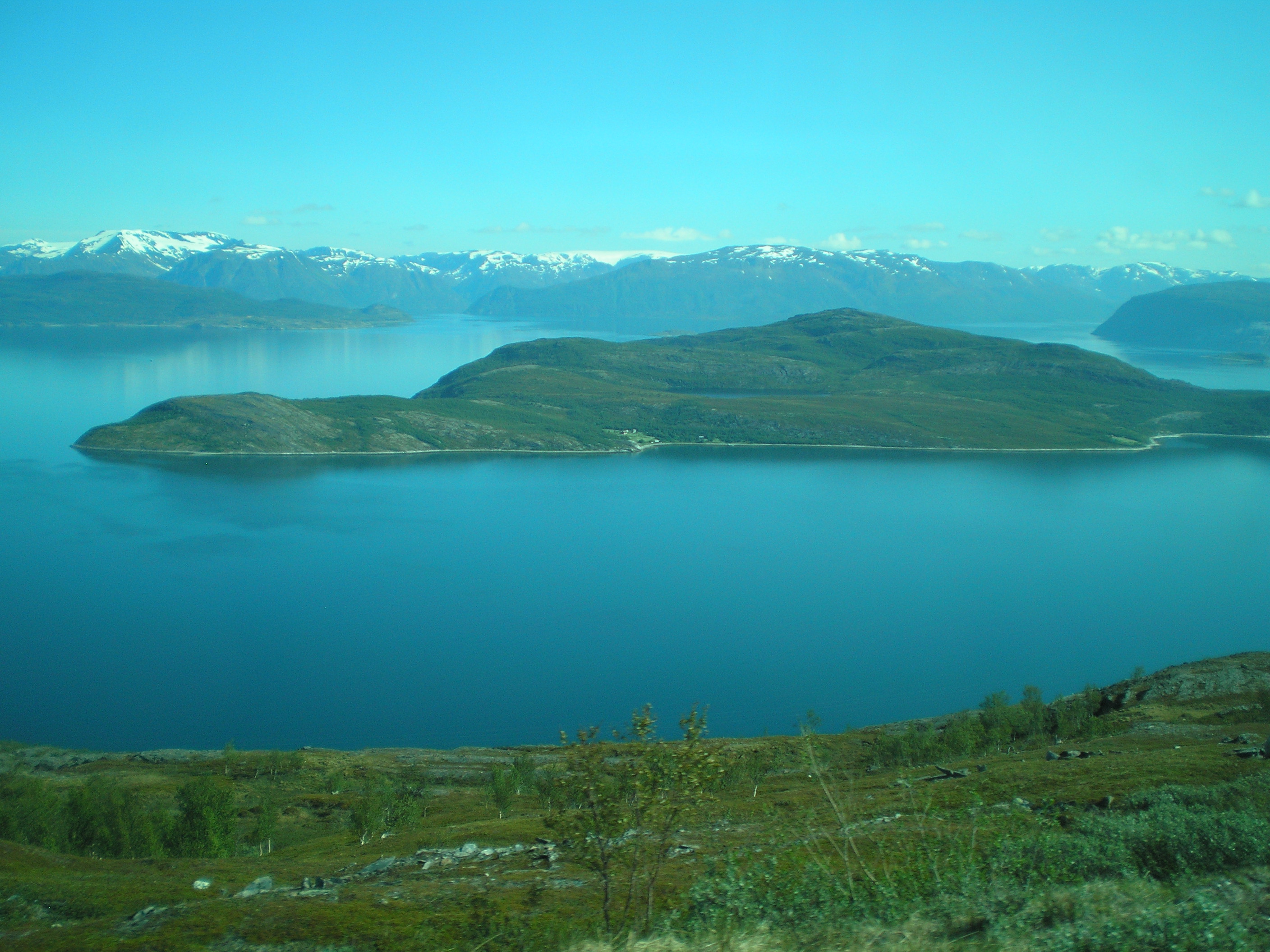
 Isfjordjøkelen, part of Øksfjordjøkelen glacier seen from Varberget | |
 Flag  Coat of arms  Troms og Finnmark within Norway | |
 Kvænangen within Troms og Finnmark | |
| Coordinates: 69°53′39″N 21°58′49″E | |
| Country | Norway |
| County | Troms og Finnmark |
| District | Nord-Troms |
| Established | 1863 |
| • Preceded by | Skjervøy Municipality |
| Administrative centre | Burfjord |
| Government | |
| • Mayor (2015) | Eirik Losnegaard Mevik (Ap) |
| Area | |
| • Total | 2,109.31 km2 (814.41 sq mi) |
| • Land | 2,008.47 km2 (775.47 sq mi) |
| • Water | 100.84 km2 (38.93 sq mi) 4.8% |
| • Rank | #32 in Norway |
| Population (2022) | |
| • Total | 1,159 |
| • Rank | #323 in Norway |
| • Density | 0.6/km2 (2/sq mi) |
| • Change (10 years) | |
| Demonym | Kvænangsværing[1] |
| Official language | |
| • Norwegian form | Neutral |
| Time zone | UTC+01:00 (CET) |
| • Summer (DST) | UTC+02:00 (CEST) |
| ISO 3166 code | NO-5429 |
| Website | Official website |
The 2,109-square-kilometre (814 sq mi) municipality is the 32nd largest by area out of the 356 municipalities in Norway. Kvænangen is the 323rd most populous municipality in Norway with a population of 1,159. The municipality's population density is 0.6 inhabitants per square kilometre (1.6/sq mi) and its population has decreased by 9.7% over the previous 10-year period.[4][5]
General information
The municipality of Kvænangen was established in 1863 when it was separated from the large Skjervøy Municipality. The initial population of Kvænangen was 1,677. During the 1960s, there were many municipal mergers across Norway due to the work of the Schei Committee. On 1 January 1965, the Meiland area (population: 12) of Skjervøy Municipality was transferred to Kvænangen. On 1 January 1972, the uninhabited area of Mannskarvik was transferred from Skjervøy to Kvænanagen.[6]
On 1 January 2020, the municipality became part of the newly formed Troms og Finnmark county. Previously, it had been part of the old Troms county.[7]
Name
The municipality is named after the Kvænangen fjord (Old Norse: Kven(a)angr). The first element is the plural genitive case of kven and the last element is angr which means "fjord". The district used to be mostly populated by Sámi people.[8]
Coat of arms
The coat of arms was granted on 13 July 1990. The arms show three blue harebells on a gray or white background. The plant is a typical plant for the area with its harsh and cold climate.[3][9]
Churches
The Church of Norway has one parish (sokn) within the municipality of Kvænangen. It is part of the Nord-Troms prosti (deanery) in the Diocese of Nord-Hålogaland.
| Parish (sokn) | Name | Location | Year built |
|---|---|---|---|
| Kvænangen | Burfjord Church | Burfjord | 2009 |
| Sekkemo Church | Sekkemo | 1956 | |
| Skorpa Church | Skorpa | 1850 |
History
The municipality surrounds the Kvænangen fjord, after which it is named. The population is primarily of Sami origin, although the Kven population constitutes a sizeable minority. Archeological finds indicate nomadic activity in the area going back 10,000 years.
There is evidence that Kværnangen was the site for a transitional state between nomadic and agricultural society through what was known as "siida" - delimited areas where permanent housing was established and natural resources put under stewardship.
The Kvens settled in the area in the 18th century, occupying themselves with fishing, hunting, and agriculture. Over time, fisheries became a primary industry, and the community exported dried fish to southern areas. Ethnic Norwegians gradually immigrated to facilitate trade and administration.
Norwegian public policy in the 1930s and post-war years homogenized the three groups, ethnic Norwegians, Sami, and Kven, considerably, to the point that most residents speak Norwegian at home, regardless of their ethnic heritage. A majority of people in Kvænangen declared themselves Sami or Kven in the 1930 census. In the 1950 census, all but a handful declared themselves Norwegian.
During the Nazi occupation during World War II, a temporary work camp was established at Kvænangen. In large part due to the generosity of the local population, prisoners had ample food. As the German Wehrmacht retreated in early 1945, the population was evacuated by force, and all buildings were burned. Today, a local museum shows typical reconstruction houses.
Geography

The municipality has coastal and plains geography, extending into Finnmarksvidda. There are mature pine forests in the valley at the head of the fjord, and there are several rivers, the largest of which is Kvænangselva, which is traditionally a good salmon-fishing river.

The Øksfjordjøkelen glacier is located in the northern part of the municipality on the border with Loppa. It's the ninth largest glacier in mainland Norway. The lake Šuoikkatjávri is located in the southern part of the municipality on the border with Kautokeino. The Langfjordjøkelen is another glacier in northern Kvænangen.
There are several islands in the fjord that are part of Kvænangen municipality: Skorpa, Spildra, and Nøklan.
Climate
Kvænangen has a boreal climate with mild winters for this climate type, and very moderate precipitation with little variation between the seasons. The Köppen Climate Classification subtype for this climate is "Dfc". (Continental Subarctic Climate).[10] The all-time high temperature is 30.5 °C (86.9 °F) recorded 7 July 2021; the all-time low is −21.5 °C (−6.7 °F) recorded 6 February 2012. Norwegian Meteorological Institute has been operating a weather station in Nordstraum in Kvænangen since 1965.
| Climate data for Nordstraum in Kvænangen 1991-2020 (20 m) | |||||||||||||
|---|---|---|---|---|---|---|---|---|---|---|---|---|---|
| Month | Jan | Feb | Mar | Apr | May | Jun | Jul | Aug | Sep | Oct | Nov | Dec | Year |
| Daily mean °C (°F) | −3.2 (26.2) |
−3.6 (25.5) |
−1.8 (28.8) |
1.4 (34.5) |
5.8 (42.4) |
9.8 (49.6) |
12.9 (55.2) |
12 (54) |
8.5 (47.3) |
3.6 (38.5) |
0.3 (32.5) |
−1.7 (28.9) |
3.7 (38.7) |
| Average precipitation mm (inches) | 46 (1.8) |
32 (1.3) |
37 (1.5) |
26 (1.0) |
28 (1.1) |
39 (1.5) |
48 (1.9) |
55 (2.2) |
47 (1.9) |
51 (2.0) |
34 (1.3) |
42 (1.7) |
485 (19.2) |
| Source: seklima.met.no[11] | |||||||||||||
| Climate data for Kvænangen | |||||||||||||
|---|---|---|---|---|---|---|---|---|---|---|---|---|---|
| Month | Jan | Feb | Mar | Apr | May | Jun | Jul | Aug | Sep | Oct | Nov | Dec | Year |
| Average high °C (°F) | −2 (28) |
−2 (29) |
0 (32) |
3 (37) |
8 (46) |
13 (55) |
16 (60) |
14 (58) |
10 (50) |
5 (41) |
1 (34) |
−1 (31) |
5 (41) |
| Average low °C (°F) | −8 (18) |
−7 (19) |
−5 (23) |
−2 (28) |
2 (36) |
6 (43) |
9 (49) |
8 (47) |
5 (41) |
1 (33) |
−3 (26) |
−6 (21) |
0 (32) |
| Average precipitation mm (inches) | 36 (1.4) |
33 (1.3) |
33 (1.3) |
23 (0.9) |
23 (0.9) |
30 (1.2) |
51 (2) |
51 (2) |
43 (1.7) |
53 (2.1) |
41 (1.6) |
41 (1.6) |
460 (18.1) |
| Source: Weatherbase [12] | |||||||||||||
Government
All municipalities in Norway, including Kvænangen, are responsible for primary education (through 10th grade), outpatient health services, senior citizen services, unemployment and other social services, zoning, economic development, and municipal roads. The municipality is governed by a municipal council of elected representatives, which in turn elect a mayor.[13] The municipality falls under the Nord-Troms District Court and the Hålogaland Court of Appeal.
Municipal council
The municipal council (Kommunestyre) of Kvænangen is made up of 15 representatives that are elected every four years. The party breakdown of the council is as follows:
| Party Name (in Norwegian) | Number of representatives | |
|---|---|---|
| Labour Party (Arbeiderpartiet) | 6 | |
| Centre Party (Senterpartiet) | 3 | |
| Socialist Left Party (Sosialistisk Venstreparti) | 2 | |
| Joint list of the Conservative Party (Høyre) and the Progress Party (Fremskrittspartiet) | 2 | |
| Kvænangen Local List (Kvænangen Bygdeliste) | 2 | |
| Total number of members: | 15 | |
| Party Name (in Norwegian) | Number of representatives | |
|---|---|---|
| Labour Party (Arbeiderpartiet) | 6 | |
| Progress Party (Fremskrittspartiet) | 1 | |
| Conservative Party (Høyre) | 2 | |
| Coastal Party (Kystpartiet) | 5 | |
| Socialist Left Party (Sosialistisk Venstreparti) | 1 | |
| Total number of members: | 15 | |
| Party Name (in Norwegian) | Number of representatives | |
|---|---|---|
| Labour Party (Arbeiderpartiet) | 3 | |
| Progress Party (Fremskrittspartiet) | 1 | |
| Conservative Party (Høyre) | 5 | |
| Coastal Party (Kystpartiet) | 5 | |
| Socialist Left Party (Sosialistisk Venstreparti) | 1 | |
| Total number of members: | 15 | |
| Party Name (in Norwegian) | Number of representatives | |
|---|---|---|
| Labour Party (Arbeiderpartiet) | 5 | |
| Progress Party (Fremskrittspartiet) | 1 | |
| Coastal Party (Kystpartiet) | 2 | |
| Socialist Left Party (Sosialistisk Venstreparti) | 2 | |
| Joint list of the Conservative Party (Høyre) and Christian Democratic Party (Kristelig Folkeparti) | 5 | |
| Total number of members: | 15 | |
| Party Name (in Norwegian) | Number of representatives | |
|---|---|---|
| Labour Party (Arbeiderpartiet) | 5 | |
| Progress Party (Fremskrittspartiet) | 2 | |
| Centre Party (Senterpartiet) | 1 | |
| Socialist Left Party (Sosialistisk Venstreparti) | 3 | |
| Joint list of the Conservative Party (Høyre) and Christian Democratic Party (Kristelig Folkeparti) | 6 | |
| Total number of members: | 17 | |
| Party Name (in Norwegian) | Number of representatives | |
|---|---|---|
| Labour Party (Arbeiderpartiet) | 4 | |
| Progress Party (Fremskrittspartiet) | 2 | |
| Centre Party (Senterpartiet) | 1 | |
| Socialist Left Party (Sosialistisk Venstreparti) | 1 | |
| Joint list of the Conservative Party (Høyre) and Christian Democratic Party (Kristelig Folkeparti) | 9 | |
| Total number of members: | 17 | |
| Party Name (in Norwegian) | Number of representatives | |
|---|---|---|
| Labour Party (Arbeiderpartiet) | 7 | |
| Centre Party (Senterpartiet) | 2 | |
| Socialist Left Party (Sosialistisk Venstreparti) | 3 | |
| Joint list of the Conservative Party (Høyre) and Christian Democratic Party (Kristelig Folkeparti) | 9 | |
| Total number of members: | 21 | |
| Party Name (in Norwegian) | Number of representatives | |
|---|---|---|
| Labour Party (Arbeiderpartiet) | 8 | |
| Conservative Party (Høyre) | 5 | |
| Christian Democratic Party (Kristelig Folkeparti) | 3 | |
| Socialist Left Party (Sosialistisk Venstreparti) | 3 | |
| Kvænangen cross-party list (Kvænangen tverrpolitiske liste) | 1 | |
| Jøkelfjord local list (Jøkelfjord kretsliste) | 1 | |
| Total number of members: | 21 | |
| Party Name (in Norwegian) | Number of representatives | |
|---|---|---|
| Labour Party (Arbeiderpartiet) | 9 | |
| Conservative Party (Høyre) | 6 | |
| Christian Democratic Party (Kristelig Folkeparti) | 2 | |
| Socialist Left Party (Sosialistisk Venstreparti) | 2 | |
| Jøkelfjord local list (Jøkelfjord kretsliste) | 2 | |
| Total number of members: | 21 | |
| Party Name (in Norwegian) | Number of representatives | |
|---|---|---|
| Labour Party (Arbeiderpartiet) | 10 | |
| Conservative Party (Høyre) | 7 | |
| Christian Democratic Party (Kristelig Folkeparti) | 3 | |
| Socialist Left Party (Sosialistisk Venstreparti) | 1 | |
| Total number of members: | 21 | |
| Party Name (in Norwegian) | Number of representatives | |
|---|---|---|
| Labour Party (Arbeiderpartiet) | 8 | |
| Conservative Party (Høyre) | 5 | |
| Christian Democratic Party (Kristelig Folkeparti) | 4 | |
| Socialist Left Party (Sosialistisk Venstreparti) | 1 | |
| Joint list of the Centre Party (Senterpartiet) and the Liberal Party (Venstre) | 1 | |
| Alteidet and Jøkelfjord local list (Alteidet og Jøkelfjord Kretsliste) | 1 | |
| Burfjord local list (Burfjord Kretsliste) | 1 | |
| Total number of members: | 21 | |
| Party Name (in Norwegian) | Number of representatives | |
|---|---|---|
| Labour Party (Arbeiderpartiet) | 7 | |
| Conservative Party (Høyre) | 4 | |
| Christian Democratic Party (Kristelig Folkeparti) | 4 | |
| Centre Party (Senterpartiet) | 1 | |
| Alteidet and Jøkelfjord local list (Alteidet og Jøkelfjord Kretsliste) | 3 | |
| Workers', farmers' and housewives' non-party common list (Arbeidernes, Småbrukernes og Husmødrenes Upolitiske Fellesliste) | 1 | |
| Kvænangsbotn Non-party district list (Kvænangsbotn Upolitiske distriktsliste) | 1 | |
| Total number of members: | 21 | |
| Party Name (in Norwegian) | Number of representatives | |
|---|---|---|
| Labour Party (Arbeiderpartiet) | 7 | |
| Liberal Party (Venstre) | 1 | |
| Local List(s) (Lokale lister) | 13 | |
| Total number of members: | 21 | |
| Party Name (in Norwegian) | Number of representatives | |
|---|---|---|
| Labour Party (Arbeiderpartiet) | 10 | |
| Conservative Party (Høyre) | 5 | |
| Socialist People's Party (Sosialistisk Folkeparti) | 3 | |
| Liberal Party (Venstre) | 2 | |
| Local List(s) (Lokale lister) | 1 | |
| Total number of members: | 21 | |
| Party Name (in Norwegian) | Number of representatives | |
|---|---|---|
| Labour Party (Arbeiderpartiet) | 9 | |
| Christian Democratic Party (Kristelig Folkeparti) | 3 | |
| Socialist People's Party (Sosialistisk Folkeparti) | 2 | |
| Local List(s) (Lokale lister) | 7 | |
| Total number of members: | 21 | |
| Party Name (in Norwegian) | Number of representatives | |
|---|---|---|
| Labour Party (Arbeiderpartiet) | 7 | |
| List of workers, fishermen, and small farmholders (Arbeidere, fiskere, småbrukere liste) | 5 | |
| Local List(s) (Lokale lister) | 9 | |
| Total number of members: | 21 | |
| Party Name (in Norwegian) | Number of representatives | |
|---|---|---|
| Labour Party (Arbeiderpartiet) | 11 | |
| Liberal Party (Venstre) | 4 | |
| Local List(s) (Lokale lister) | 6 | |
| Total number of members: | 21 | |
| Party Name (in Norwegian) | Number of representatives | |
|---|---|---|
| Labour Party (Arbeiderpartiet) | 3 | |
| Liberal Party (Venstre) | 5 | |
| List of workers, fishermen, and small farmholders (Arbeidere, fiskere, småbrukere liste) | 5 | |
| Local List(s) (Lokale lister) | 3 | |
| Total number of members: | 16 | |
| Party Name (in Norwegian) | Number of representatives | |
|---|---|---|
| Labour Party (Arbeiderpartiet) | 10 | |
| Joint List(s) of Non-Socialist Parties (Borgerlige Felleslister) | 5 | |
| Local List(s) (Lokale lister) | 1 | |
| Total number of members: | 16 | |
| Party Name (in Norwegian) | Number of representatives | |
|---|---|---|
| Labour Party (Arbeiderpartiet) | 10 | |
| Local List(s) (Lokale lister) | 6 | |
| Total number of members: | 16 | |
| Party Name (in Norwegian) | Number of representatives | |
|---|---|---|
| Labour Party (Arbeiderpartiet) | 7 | |
| List of workers, fishermen, and small farmholders (Arbeidere, fiskere, småbrukere liste) | 5 | |
| Joint List(s) of Non-Socialist Parties (Borgerlige Felleslister) | 2 | |
| Local List(s) (Lokale lister) | 2 | |
| Total number of members: | 16 | |
| Note: Due to the German occupation of Norway during World War II, no elections were held for new municipal councils until after the war ended in 1945. | ||
Notable people

Notable people that were born or lived in Kvænangen include:
- Anders Larsen (1870–1949), Sami teacher, journalist and author
- Jafet Lindeberg (1873–1962), a gold prospector and co-founder of Nome, Alaska
- Gunnar Kaasen (1882–1960), Norwegian-American musher, helped the 1925 serum run to Nome
- Hans Eng (1907–1995) a Norwegian physician and Nazi collaborator during World War II
- Steinar Eriksen (born 1939), Norwegian businessperson and politician
- Odd Rikard Olsen (1947–2012), Norwegian newspaper editor and politician
- Eva M. Nielsen (born 1950), Norwegian politician
- Torgeir Johnsen, (Norwegian Wiki) (born 1967), Norwegian politician
References
- "Navn på steder og personer: Innbyggjarnamn" (in Norwegian). Språkrådet.
- "Forskrift om målvedtak i kommunar og fylkeskommunar" (in Norwegian). Lovdata.no.
- Store norske leksikon. "Kvænangen" (in Norwegian). Retrieved 7 April 2010.
- Statistisk sentralbyrå. "Table: 06913: Population 1 January and population changes during the calendar year (M)" (in Norwegian).
- Statistisk sentralbyrå. "09280: Area of land and fresh water (km²) (M)" (in Norwegian).
- Jukvam, Dag (1999). "Historisk oversikt over endringer i kommune- og fylkesinndelingen" (PDF) (in Norwegian). Statistisk sentralbyrå.
- Mæhlum, Lars, ed. (24 December 2019). "Troms og Finnmark". Store norske leksikon (in Norwegian). Kunnskapsforlaget. Retrieved 26 December 2019.
- Rygh, Oluf (1911). Norske gaardnavne: Troms amt (in Norwegian) (17 ed.). Kristiania, Norge: W. C. Fabritius & sønners bogtrikkeri. p. 189.
- "Civic heraldry of Norway - Norske Kommunevåpen". Heraldry of the World. Retrieved 2 August 2018.
- Climate Summary for Nordstraum (closest city on record to Kvænangen)
- "seklima.met.no". Norwegian Meteorological Institute.
- "Weatherbase.com". Weatherbase. 2013. Retrieved 20 May 2013.
- Hansen, Tore, ed. (12 May 2016). "kommunestyre". Store norske leksikon (in Norwegian). Kunnskapsforlaget. Retrieved 2 August 2018.
- "Tall for Norge: Kommunestyrevalg 2019 - Troms og Finnmark". Valg Direktoratet. Retrieved 26 October 2019.
- "Table: 04813: Members of the local councils, by party/electoral list at the Municipal Council election (M)" (in Norwegian). Statistics Norway.
- "Tall for Norge: Kommunestyrevalg 2011 - Troms Romsa". Valg Direktoratet. Retrieved 26 October 2019.
- "Kommunestyrevalget 1995" (PDF) (in Norwegian). Oslo-Kongsvinger: Statistisk sentralbyrå. 1996. Retrieved 21 March 2020.
- "Kommunestyrevalget 1991" (PDF) (in Norwegian). Oslo-Kongsvinger: Statistisk sentralbyrå. 1993. Retrieved 21 March 2020.
- "Kommunestyrevalget 1987" (PDF) (in Norwegian). Oslo-Kongsvinger: Statistisk sentralbyrå. 1988. Retrieved 21 March 2020.
- "Kommunestyrevalget 1983" (PDF) (in Norwegian). Oslo-Kongsvinger: Statistisk sentralbyrå. 1984. Retrieved 21 March 2020.
- "Kommunestyrevalget 1979" (PDF) (in Norwegian). Oslo: Statistisk sentralbyrå. 1979. Retrieved 21 March 2020.
- "Kommunevalgene 1975" (PDF) (in Norwegian). Oslo: Statistisk sentralbyrå. 1977. Retrieved 21 March 2020.
- "Kommunevalgene 1972" (PDF) (in Norwegian). Oslo: Statistisk sentralbyrå. 1973. Retrieved 21 March 2020.
- "Kommunevalgene 1967" (PDF) (in Norwegian). Oslo: Statistisk sentralbyrå. 1967. Retrieved 21 March 2020.
- "Kommunevalgene 1963" (PDF) (in Norwegian). Oslo: Statistisk sentralbyrå. 1964. Retrieved 21 March 2020.
- "Kommunevalgene og Ordførervalgene 1959" (PDF) (in Norwegian). Oslo: Statistisk sentralbyrå. 1960. Retrieved 21 March 2020.
- "Kommunevalgene og Ordførervalgene 1955" (PDF) (in Norwegian). Oslo: Statistisk sentralbyrå. 1957. Retrieved 21 March 2020.
- "Kommunevalgene og Ordførervalgene 1951" (PDF) (in Norwegian). Oslo: Statistisk sentralbyrå. 1952. Retrieved 21 March 2020.
- "Kommunevalgene og Ordførervalgene 1947" (PDF) (in Norwegian). Oslo: Statistisk sentralbyrå. 1948. Retrieved 21 March 2020.
- "Kommunevalgene og Ordførervalgene 1945" (PDF) (in Norwegian). Oslo: Statistisk sentralbyrå. 1947. Retrieved 21 March 2020.
- "Kommunevalgene og Ordførervalgene 1937" (PDF) (in Norwegian). Oslo: Statistisk sentralbyrå. 1938. Retrieved 21 March 2020.
External links
- Municipal fact sheet from Statistics Norway (in Norwegian)
 Media related to Kvænangen at Wikimedia Commons
 The dictionary definition of Kvænangen at Wiktionary
 Troms travel guide from Wikivoyage
Troms og Finnmark county, Norway | |||||||||
|---|---|---|---|---|---|---|---|---|---|
| |||||||||
 | Towns and cities |
|   | ||||||
| Municipalities |
| ||||||||
| Authority control |
|
|---|
На других языках
[de] Kvænangen (Kommune)
Kvænangen (nordsamisch: Návuona suohkan[2]) ist eine Kommune im norwegischen Fylke Troms og Finnmark. Die Kommune hat 1159 Einwohner (Stand: 1. Januar 2022). Verwaltungssitz ist die Ortschaft Burfjord.- [en] Kvænangen
[ru] Квенанген
Квенанген (норв. Kvænangen) — коммуна в губернии Тромс-ог-Финнмарк в Норвегии. Административный центр коммуны — город Бурфьорд. Официальный язык коммуны — нейтральный[1]. Население коммуны на 2017 год составляло 1233 чел. Площадь коммуны Квенанген — 2108,26 км², код-идентификатор — 1943.Другой контент может иметь иную лицензию. Перед использованием материалов сайта WikiSort.org внимательно изучите правила лицензирования конкретных элементов наполнения сайта.
WikiSort.org - проект по пересортировке и дополнению контента Википедии