world.wikisort.org - Norway
Båtsfjord (Northern Sami: Báhcavuotna) is a municipality in Troms og Finnmark county, Norway. The administrative centre of the municipality is the village of Båtsfjord (which is the only settlement remaining in the municipality). Båtsfjord Airport is a new, modern airport, located just outside Båtsfjord village. The Hurtigruten coastal express ferry also has regularly-scheduled stops in Båtsfjord village.
Båtsfjord kommune
Báhcavuona gielda | |
|---|---|
Municipality | |
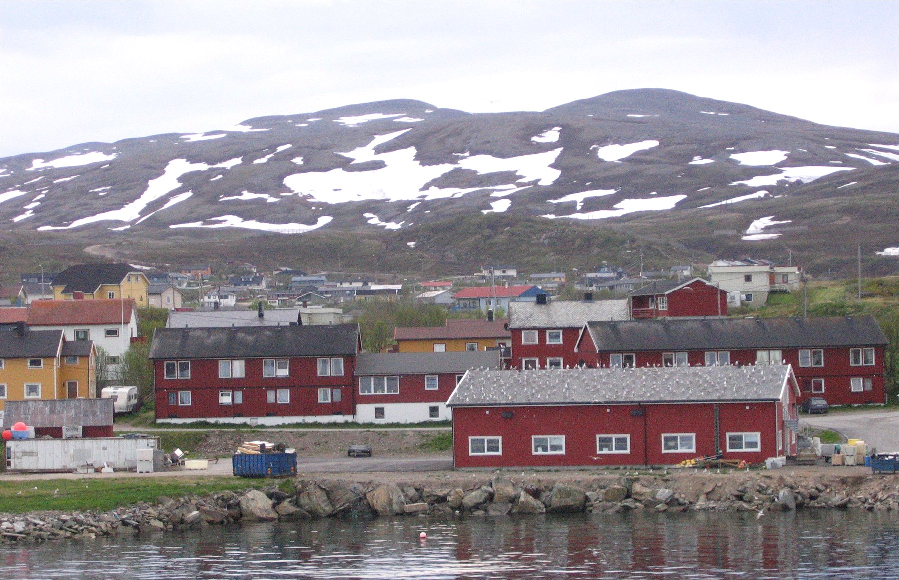 View of Båtsfjord village | |
 Flag  Coat of arms  Troms og Finnmark within Norway | |
 Båtsfjord within Troms og Finnmark | |
| Coordinates: 70°38′07″N 29°43′15″E | |
| Country | Norway |
| County | Troms og Finnmark |
| District | Øst-Finnmark |
| Established | 1839 |
| • Preceded by | Vardø Municipality |
| Administrative centre | Båtsfjord |
| Government | |
| • Mayor (2019) | Ronald Wærnes (Sp) |
| Area | |
| • Total | 1,434.78 km2 (553.97 sq mi) |
| • Land | 1,416.05 km2 (546.74 sq mi) |
| • Water | 18.73 km2 (7.23 sq mi) 1.3% |
| • Rank | #63 in Norway |
| Population (2022) | |
| • Total | 2,165 |
| • Rank | #269 in Norway |
| • Density | 1.5/km2 (4/sq mi) |
| • Change (10 years) | |
| Demonym | Båtsfjording[1] |
| Official language | |
| • Norwegian form | Neutral |
| Time zone | UTC+01:00 (CET) |
| • Summer (DST) | UTC+02:00 (CEST) |
| ISO 3166 code | NO-5443 |
| Website | Official website |
The 1,435-square-kilometre (554 sq mi) municipality is the 60th largest by area out of the 356 municipalities in Norway. Båtsfjord is the 269th most populous municipality in Norway with a population of 2,165. The municipality's population density is 1.5 inhabitants per square kilometre (3.9/sq mi) and its population has increased by 3.6% over the previous 10-year period.[3][4]
Historically, there were many other villages in the municipality, but they have been abandoned over the years. Some of these villages include Hamningberg (abandoned in 1964), Makkaur (abandoned in the 1950s), Sandfjord/Ytre Syltefjord (abandoned in 1946), Hamna (abandoned around 1950), and Nordfjord (abandoned in 1989).
General information


Vardø Municipality was established on 1 January 1838 (see formannskapsdistrikt law), encompassing the northeastern part of the Varanger Peninsula. In 1839, to comply with the formannskapsdistrikt law, the rural parts of the municipality, outside of the island/town of Vardø, were separated to form the new municipality of Vardø landdistrikt. Initially, Vardø landdistrikt had a population of 245. The new municipality was too small to be an official self-governing municipality, and it was not until 22 May 1868 when a royal resolution was passed that officially declared it a self-governing municipality. On 1 January 1874, a small part of Vardø landdistrikt (population: 48) was transferred to the town of Vardø. On 1 January 1955, the name was changed to Båtsfjord. During the 1960s, there were many municipal mergers across Norway due to the work of the Schei Committee. On 1 January 1964, the eastern fourth of Båtsfjord (population: 621) was transferred to the neighboring Vardø Municipality.[5][6]
On 1 January 2020, the municipality became part of the newly formed Troms og Finnmark county. Previously, it had been part of the old Finnmark county.[7]
Name
The name was originally Vardø landdistrikt (or Vardø landsogn) which both mean "the rural district of Vardø", since it surrounded the town of Vardø. On 1 January 1955, the name was changed to Båtsfjord since the village of Båtsfjord is the main population centre of the municipality. The Old Norse form of the name is Botnsfjǫrðr. The first element is the genitive case of botn which means "the innermost part of a fjord" and the second part is the Old Norse spelling for "fjord". The village is located at the innermost part of a fjord, so the name has a very straightforward meaning.[8]
Coat of arms
The coat of arms was granted on 19 April 1985. The arms show a silver fish hook on a blue background. It was chosen as a symbol for the great economic importance of fishing and fish processing in the municipality. The shape of the hook was derived from ancient Stone Age hooks found in the municipality.[9]
Government
All municipalities in Norway, including Båtsfjord, are responsible for primary education (through 10th grade), outpatient health services, senior citizen services, unemployment and other social services, zoning, economic development, and municipal roads. The municipality is governed by a municipal council of elected representatives, which in turn elect a mayor.[10] The municipality falls under the Øst-Finnmark District Court and the Hålogaland Court of Appeal.
Municipal council
The municipal council (Kommunestyre) of Båtsfjord is made up of 15 representatives that are elected to four year terms. The party breakdown of the council is as follows:
| Party Name (in Norwegian) | Number of representatives | |
|---|---|---|
| Labour Party (Arbeiderpartiet) | 5 | |
| Conservative Party (Høyre) | 3 | |
| Centre Party (Senterpartiet) | 7 | |
| Total number of members: | 15 | |
| Party Name (in Norwegian) | Number of representatives | |
|---|---|---|
| Labour Party (Arbeiderpartiet) | 8 | |
| Conservative Party (Høyre) | 7 | |
| Total number of members: | 15 | |
| Party Name (in Norwegian) | Number of representatives | |
|---|---|---|
| Labour Party (Arbeiderpartiet) | 8 | |
| Conservative Party (Høyre) | 6 | |
| Båtsfjord List (Båtsfjordlista) | 1 | |
| Total number of members: | 15 | |
| Party Name (in Norwegian) | Number of representatives | |
|---|---|---|
| Labour Party (Arbeiderpartiet) | 9 | |
| Progress Party (Fremskrittspartiet) | 2 | |
| Conservative Party (Høyre) | 4 | |
| Total number of members: | 15 | |
| Party Name (in Norwegian) | Number of representatives | |
|---|---|---|
| Labour Party (Arbeiderpartiet) | 9 | |
| Conservative Party (Høyre) | 2 | |
| Socialist Left Party (Sosialistisk Venstreparti) | 1 | |
| Båtsfjord Cross-Party List (Båtsfjord Tverrpolitiske Liste) | 3 | |
| Total number of members: | 15 | |
| Party Name (in Norwegian) | Number of representatives | |
|---|---|---|
| Labour Party (Arbeiderpartiet) | 9 | |
| Conservative Party (Høyre) | 6 | |
| Socialist Left Party (Sosialistisk Venstreparti) | 1 | |
| Båtsfjord Cross-Party List (Båtsfjord Tverrpolitiske Liste) | 5 | |
| Total number of members: | 21 | |
| Party Name (in Norwegian) | Number of representatives | |
|---|---|---|
| Labour Party (Arbeiderpartiet) | 11 | |
| Conservative Party (Høyre) | 3 | |
| Christian Democratic Party (Kristelig Folkeparti) | 2 | |
| Båtsfjord Cross-Party List (Båtsfjord Tverrpolitiske Liste) | 5 | |
| Total number of members: | 21 | |
| Party Name (in Norwegian) | Number of representatives | |
|---|---|---|
| Labour Party (Arbeiderpartiet) | 12 | |
| Conservative Party (Høyre) | 4 | |
| Socialist Left Party (Sosialistisk Venstreparti) | 3 | |
| Liberal Party (Venstre) | 2 | |
| Total number of members: | 21 | |
| Party Name (in Norwegian) | Number of representatives | |
|---|---|---|
| Labour Party (Arbeiderpartiet) | 14 | |
| Conservative Party (Høyre) | 5 | |
| Socialist Left Party (Sosialistisk Venstreparti) | 1 | |
| Liberal Party (Venstre) | 1 | |
| Total number of members: | 21 | |
| Party Name (in Norwegian) | Number of representatives | |
|---|---|---|
| Labour Party (Arbeiderpartiet) | 15 | |
| Conservative Party (Høyre) | 4 | |
| Socialist Left Party (Sosialistisk Venstreparti) | 2 | |
| Total number of members: | 21 | |
| Party Name (in Norwegian) | Number of representatives | |
|---|---|---|
| Labour Party (Arbeiderpartiet) | 13 | |
| Conservative Party (Høyre) | 6 | |
| Socialist Left Party (Sosialistisk Venstreparti) | 2 | |
| Total number of members: | 21 | |
| Party Name (in Norwegian) | Number of representatives | |
|---|---|---|
| Labour Party (Arbeiderpartiet) | 13 | |
| Conservative Party (Høyre) | 4 | |
| Christian Democratic Party (Kristelig Folkeparti) | 1 | |
| Socialist Left Party (Sosialistisk Venstreparti) | 3 | |
| Total number of members: | 21 | |
| Party Name (in Norwegian) | Number of representatives | |
|---|---|---|
| Labour Party (Arbeiderpartiet) | 16 | |
| Conservative Party (Høyre) | 3 | |
| Socialist common list (Venstresosialistiske felleslister) | 2 | |
| Total number of members: | 21 | |
| Party Name (in Norwegian) | Number of representatives | |
|---|---|---|
| Labour Party (Arbeiderpartiet) | 12 | |
| Conservative Party (Høyre) | 3 | |
| Socialist People's Party (Sosialistisk Folkeparti) | 2 | |
| Total number of members: | 17 | |
| Party Name (in Norwegian) | Number of representatives | |
|---|---|---|
| Labour Party (Arbeiderpartiet) | 10 | |
| Conservative Party (Høyre) | 4 | |
| Socialist People's Party (Sosialistisk Folkeparti) | 3 | |
| Total number of members: | 17 | |
| Party Name (in Norwegian) | Number of representatives | |
|---|---|---|
| Labour Party (Arbeiderpartiet) | 11 | |
| Conservative Party (Høyre) | 3 | |
| Communist Party (Kommunistiske Parti) | 3 | |
| Total number of members: | 17 | |
| Party Name (in Norwegian) | Number of representatives | |
|---|---|---|
| Labour Party (Arbeiderpartiet) | 10 | |
| Communist Party (Kommunistiske Parti) | 4 | |
| Christian Democratic Party (Kristelig Folkeparti) | 1 | |
| Local List(s) (Lokale lister) | 2 | |
| Total number of members: | 17 | |
| Party Name (in Norwegian) | Number of representatives | |
|---|---|---|
| Labour Party (Arbeiderpartiet) | 7 | |
| Communist Party (Kommunistiske Parti) | 2 | |
| Local List(s) (Lokale lister) | 7 | |
| Total number of members: | 16 | |
| Party Name (in Norwegian) | Number of representatives | |
|---|---|---|
| Labour Party (Arbeiderpartiet) | 7 | |
| Local List(s) (Lokale lister) | 9 | |
| Total number of members: | 16 | |
| Party Name (in Norwegian) | Number of representatives | |
|---|---|---|
| Labour Party (Arbeiderpartiet) | 8 | |
| Communist Party (Kommunistiske Parti) | 4 | |
| List of workers, fishermen, and small farmholders (Arbeidere, fiskere, småbrukere liste) | 2 | |
| Local List(s) (Lokale lister) | 2 | |
| Total number of members: | 16 | |
| Party Name (in Norwegian) | Number of representatives | |
|---|---|---|
| Labour Party (Arbeiderpartiet) | 6 | |
| Communist Party (Kommunistiske Parti) | 4 | |
| Local List(s) (Lokale lister) | 6 | |
| Total number of members: | 16 | |
| Note: Due to the German occupation of Norway during World War II, no elections were held for new municipal councils until after the war ended in 1945. | ||
Mayors
The mayors of Båtsfjord (incomplete list):
- 2019–present: Ronald Wærnes (Sp)
- 2011-2019: Geir Knutsen (Ap)
- 2009-2011: Gunn Marit Nilsen (H)
- 2007-2009: Frank Bakke-Jensen (H)
- 2003-2007: Geir Knutsen (Ap)
- 1999-2003: Just Hjalmar Johansen (H)
- 1992-1999: Leif Arne Viken (Ap)
Geography

The municipality covers an area of 1,433 square kilometres (553 sq mi) including Finnmark's highest mountain pass over Ordofjell at 400 metres (1,300 ft) above sea level. It is situated on the northeastern coast of the Varanger Peninsula, on the rocky coastline of the Barents Sea. There are no native trees due to the climate. The Varangerhalvøya National Park lies in the southern part of the municipality. Makkaur Lighthouse lies along the shoreline, near the mouth of the Båtsfjorden, northeast of the village of Båtsfjord.
| Climate data for Båtsfjord | |||||||||||||
|---|---|---|---|---|---|---|---|---|---|---|---|---|---|
| Month | Jan | Feb | Mar | Apr | May | Jun | Jul | Aug | Sep | Oct | Nov | Dec | Year |
| Daily mean °C (°F) | −6.5 (20.3) |
−6.4 (20.5) |
−4.4 (24.1) |
−1.2 (29.8) |
3.0 (37.4) |
7.5 (45.5) |
11.0 (51.8) |
10.0 (50.0) |
6.5 (43.7) |
1.5 (34.7) |
−2.2 (28.0) |
−5.0 (23.0) |
1.2 (34.2) |
| Average precipitation mm (inches) | 48 (1.9) |
38 (1.5) |
35 (1.4) |
32 (1.3) |
30 (1.2) |
39 (1.5) |
49 (1.9) |
59 (2.3) |
60 (2.4) |
59 (2.3) |
48 (1.9) |
48 (1.9) |
545 (21.5) |
| Source: Norwegian Meteorological Institute[29] | |||||||||||||
Previously, there were several villages along this barren coast, but today everyone lives in the village of Båtsfjord, with a sheltered harbor at the end of the Båtsfjorden inlet. Among the now-abandoned fishing villages is Hamningberg on the outer coast, which has many well-preserved 19th century wooden houses. Now, it is only used for summer vacation stays. The world's northernmost gannet colony to be found on the stack at Syltefjordstauran, along the Syltefjorden, north of the now-abandoned village of Nordfjord. Two pairs were discovered in 1961, but the colony has now grown to well over 300 pairs.
Buildings and structures
Churches
The Church of Norway has one parish (sokn) within the municipality of Båtsfjord. It is part of the Varanger prosti (deanery) in the Diocese of Nord-Hålogaland. The main church is Båtsfjord Church. There are two other small chapels, but they are only used for special occasions since they are located in uninhabited areas that are only used for summer cottages.
| Parish (sokn) | Name | Location of the church | Year built |
|---|---|---|---|
| Båtsfjord | Båtsfjord Church | Båtsfjord | 1971 |
| Hamningberg Chapel | Hamningberg | 1949 | |
| Syltefjord Chapel | Nordfjord | 1934 |
Mast for broadcasting
- 241-metre (791 ft) high guyed mast for FM-/TV-broadcasting. See List of tallest structures in Norway.
Commerce
Fishing permits (for salmon fishing) are sold for use on specific rivers, including Sandfjord-elva, Syltefjord-elva and Komag-elva.[30] A crab factory was started in 2015; 20 - 30 million Norwegian kroner was the cost of investment—then employing 28.[31]
Notable people
- Geir Knutsen (born 1959) a Norwegian politician
- Frank Bakke-Jensen (born 1965), politician, Mayor of Båtsfjord from 2007, and Minister of Defence since 2017[32]
- Gjert Ingebrigtsen (born 1966) a Norwegian sports coach
- Jan Thore Grefstad, (Norwegian Wiki) (born 1978), rock singer and songwriter
References
- "Navn på steder og personer: Innbyggjarnamn" (in Norwegian). Språkrådet.
- "Forskrift om målvedtak i kommunar og fylkeskommunar" (in Norwegian). Lovdata.no.
- Statistisk sentralbyrå. "Table: 06913: Population 1 January and population changes during the calendar year (M)" (in Norwegian).
- Statistisk sentralbyrå. "09280: Area of land and fresh water (km²) (M)" (in Norwegian).
- Jukvam, Dag (1999). "Historisk oversikt over endringer i kommune- og fylkesinndelingen" (PDF) (in Norwegian). Statistisk sentralbyrå.
- Rygh, Oluf (1924). Norske gaardnavne: Finmarkens amt (in Norwegian) (18 ed.). Kristiania, Norge: W. C. Fabritius & sønners bogtrikkeri. p. 301.
- Mæhlum, Lars, ed. (24 December 2019). "Troms og Finnmark". Store norske leksikon (in Norwegian). Kunnskapsforlaget. Retrieved 26 December 2019.
- Rygh, Oluf (1924). Norske gaardnavne: Finmarkens amt (in Norwegian) (18 ed.). Kristiania, Norge: W. C. Fabritius & sønners bogtrikkeri. p. 309.
- Norske Kommunevåpen (1990). "Nye kommunevåbener i Norden". Archived from the original on 15 July 2007. Retrieved 8 December 2008.
- Hansen, Tore, ed. (12 May 2016). "kommunestyre". Store norske leksikon (in Norwegian). Kunnskapsforlaget. Retrieved 5 June 2018.
- "Tall for Norge: Kommunestyrevalg 2019 - Troms og Finnmark". Valg Direktoratet. Retrieved 21 October 2019.
- "Table: 04813: Members of the local councils, by party/electoral list at the Municipal Council election (M)" (in Norwegian). Statistics Norway.
- "Tall for Norge: Kommunestyrevalg 2011 - Finnmark". Valg Direktoratet. Retrieved 21 October 2019.
- "Kommunestyrevalget 1995" (PDF) (in Norwegian). Oslo-Kongsvinger: Statistisk sentralbyrå. 1996. Retrieved 20 February 2020.
- "Kommunestyrevalget 1991" (PDF) (in Norwegian). Oslo-Kongsvinger: Statistisk sentralbyrå. 1993. Retrieved 20 February 2020.
- "Kommunestyrevalget 1987" (PDF) (in Norwegian). Oslo-Kongsvinger: Statistisk sentralbyrå. 1988. Retrieved 20 February 2020.
- "Kommunestyrevalget 1983" (PDF) (in Norwegian). Oslo-Kongsvinger: Statistisk sentralbyrå. 1984. Retrieved 20 February 2020.
- "Kommunestyrevalget 1979" (PDF) (in Norwegian). Oslo: Statistisk sentralbyrå. 1979. Retrieved 20 February 2020.
- "Kommunevalgene 1975" (PDF) (in Norwegian). Oslo: Statistisk sentralbyrå. 1977. Retrieved 16 March 2020.
- "Kommunevalgene 1972" (PDF) (in Norwegian). Oslo: Statistisk sentralbyrå. 1973. Retrieved 16 March 2020.
- "Kommunevalgene 1967" (PDF) (in Norwegian). Oslo: Statistisk sentralbyrå. 1967. Retrieved 16 March 2020.
- "Kommunevalgene 1963" (PDF) (in Norwegian). Oslo: Statistisk sentralbyrå. 1964. Retrieved 16 March 2020.
- "Kommunevalgene og Ordførervalgene 1959" (PDF) (in Norwegian). Oslo: Statistisk sentralbyrå. 1960. Retrieved 16 March 2020.
- "Kommunevalgene og Ordførervalgene 1955" (PDF) (in Norwegian). Oslo: Statistisk sentralbyrå. 1957. Retrieved 16 March 2020.
- "Kommunevalgene og Ordførervalgene 1951" (PDF) (in Norwegian). Oslo: Statistisk sentralbyrå. 1952. Retrieved 16 March 2020.
- "Kommunevalgene og Ordførervalgene 1947" (PDF) (in Norwegian). Oslo: Statistisk sentralbyrå. 1948. Retrieved 16 March 2020.
- "Kommunevalgene og Ordførervalgene 1945" (PDF) (in Norwegian). Oslo: Statistisk sentralbyrå. 1947. Retrieved 16 March 2020.
- "Kommunevalgene og Ordførervalgene 1937" (PDF) (in Norwegian). Oslo: Statistisk sentralbyrå. 1938. Retrieved 16 March 2020.
- "eKlima Web Portal". Norwegian Meteorological Institute. Archived from the original on 14 June 2004.
- "Laksefiske for alle". Aftenposten. 19 July 2014. p. 11.
- «Fiskerihovedstaden» utvider med ny snøkrabbefabrikk
- Dagsavisen, December 2016
External links
 Media related to Båtsfjord at Wikimedia Commons
- Pictures of Wild life and nature in Båtsfjord
Troms og Finnmark county, Norway | |||||||||
|---|---|---|---|---|---|---|---|---|---|
| |||||||||
 | Towns and cities |
|   | ||||||
| Municipalities |
| ||||||||
На других языках
[de] Båtsfjord
Båtsfjord (nordsamisch Báhcavuonna[2]) ist eine Kommune im norwegischen Fylke Troms og Finnmark. Die Kommune liegt im Nordosten Norwegens und hat 2165 Einwohner (Stand: 1. Januar 2022). Verwaltungssitz ist der gleichnamige Ort Båtsfjord.- [en] Båtsfjord
[ru] Ботсфьорд
Ботсфьорд (норв. Båtsfjord,сев.‑саам. Báhcavuotna) — коммуна в губернии Тромс-ог-Финнмарк в Норвегии. Административный центр коммуны — город Ботсфьорд. Официальный язык коммуны — нейтральный[1]. Население коммуны на 2007 год составляло 2090 чел. Площадь коммуны Ботсфьорд — 1433,37 км², код-идентификатор — 2028.Другой контент может иметь иную лицензию. Перед использованием материалов сайта WikiSort.org внимательно изучите правила лицензирования конкретных элементов наполнения сайта.
WikiSort.org - проект по пересортировке и дополнению контента Википедии