world.wikisort.org - Nigeria
Adamawa Region
Adamawa State | |
|---|---|
State | |
 | |
 Flag  Seal | |
| Nickname: Land of Beauty/UBA | |
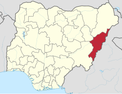 Location of Adamawa State in Nigeria | |
| Coordinates: 9°20′N 12°30′E | |
| Country | |
| Established | August 27, 1991 |
| Capital | Yola |
| Government | |
| • Body | Government of Adamawa State |
| • Governor | Umaru Fintiri (PDP) |
| • Deputy Governor | Crowther Seth (PDP) |
| • Legislature | Adamawa State House of Assembly |
| • Senators | C: Aishatu Dahiru Ahmed (APC) N: Ishaku Elisha Abbo (APC) S: Binos Dauda Yaroe (PDP) |
| • Representatives | List |
| Area | |
| • Total | 36,917 km2 (14,254 sq mi) |
| Population (2006) | |
| • Total | 3,178,950 |
| Time zone | UTC+1 (GMT) |
| Postal code | 640001 |
| Dialing Code | +234 |
| Geocode | NG-AD |
| GDP (2007) | $4.58 billion[1] |
| GDP Per Capita | $1,417[1] |
| HDI (2019) | 0.488[2] low · 27th of 37 |
| Website | www.adamawastate.gov.ng |
Adamawa state (Fula: Leydi Adamaawa 𞤤𞤫𞤴𞤣𞤭 𞤢𞤣𞤢𞤥𞤢𞥄𞤱𞤢) is a state in the North-East geopolitical zone of Nigeria, bordered by Borno to the northwest, Gombe to the west, and Taraba to the southwest, while its eastern border forms part of the national border with Cameroon. It takes its name from the historic emirate of Adamawa, with the emirate's old capital of Yola, serving as the capital city of Adamawa state. The state is one of the most heterogeneous in Nigeria. with over 100 indigenous ethnic groups, formed in 1991, when the former Gongola state was broken up into Adamawa and Taraba states.[3][4] Since its was carved out of the old Gongola State in 1991 by the General Ibrahim Badamsi Babangida military regime, Adamawa State has had 10 men, both military and civilian, controlling the levers of power, who played crucial roles in transforming the state into what it is today.[5]
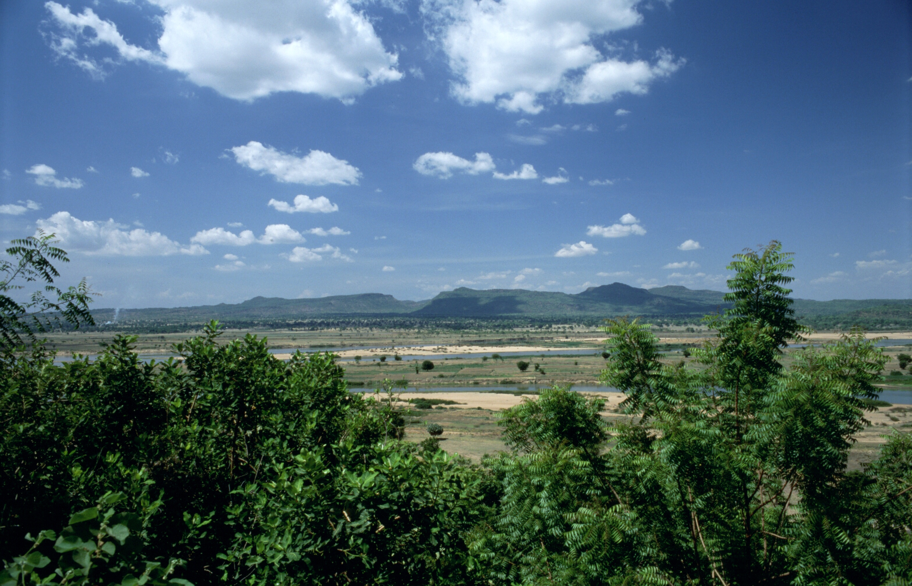
Of the 36 states in Nigeria, Adamawa state is the eighth largest in area, but the thirteenth least populous with an estimated popupation of about 4.25 million as of 2016.[6] Geographically, the state is mainly composed of the highlands of mountains (the Atlantika, Mandara, and the Shebshi ranges) and the Adamawa Plateau, crossed by valleys and rivers, most notably the Benue and Gongola rivers. The lowlands of Adamawa are part of the West Sudanian savanna in the north and the wetter Guinean forest–savanna mosaic in parts of the south, while elevated areas are parts of the Mandara Plateau mosaic and Cameroonian Highlands forests ecoregions. In the extreme south of the state is part of the Gashaka Gumti National Park, a large wildlife park that contains large populations of bushbuck, African buffalo, patas monkey, black-and-white colobus, giant pangolin, and hippopotamus along with some of Nigeria's last remaining Nigeria-Cameroon chimpanzee, African leopard, and African golden cat populations.[7][8]
What is now Adamawa state has been inhabited for years by various ethnic groups, including the Bwatiye (Bachama), Bali, Bata (Gbwata), Gudu, Mbula-Bwazza, and Nungurab (Lunguda) in the central region; the Kamwe in the north and central region; the Jibu in the far south; the Kilba, Marghi, Waga, and Wula in the north, and the Mumuye in the south, while the Fulani live throughout the state—often as nomadic herders. Adamawa state is also religiously diverse as about 55% of the population is Sunni Muslim and 30% is Christian (mainly Lutheran, EYN, ECWA, and Pentecostal), while the remaining 15% are adherents of traditional ethnic religions.[9][10]
In the early 1800s, the Fulani jihad captured some of modern-day Adamawa state and formed the Adamawa Emirate under the Sokoto Caliphate. About 90 years later, forces from Germany and the British Empire defeated the Emirate in the Adamawa Wars and split the area. The British-controlled area (much of the west of modern-day Adamawa) was incorporated into the Northern Nigeria Protectorate, which later merged to constitute British Nigeria, before becoming an independent state-- Nigeria, in 1960. The German-controlled area formed a part of German Kamerun until allied forces invaded and occupied Kamerun during the Kamerun campaign of World War I. After the war, what is now eastern Adamawa state became most of the Northern Cameroons within the British Cameroons, until 1961, when a referendum led to itsmerger with Nigeria. Originally, modern-day Adamawa State was a part of the post-independence Northern Region until 1967 when the region was split and the area became part of the North-Eastern State. After the North-Eastern state was split in 1976, Gongola State was formed on 3 February 1976 alongside ten other states. Fifteen years after statehood, Gongola was split with the state's south becoming Taraba State while its north became Adamawa State.
As an agriculturally-based state, the Adamawa State economy mainly relies on livestock and crops, such as cotton, groundnuts, millet, cassava, guinea corn, and yams. After years of the Boko Haram insurgency affecting development in the state,[11] Adamawa has the eleventh lowest Human Development Index in the country but as the insurgency has abated since 2016, development has renewed.[2][12]
Geography
Adamawa is one of the largest states of Nigeria and occupies about 36,917 square kilometers.[13] It is bordered by the states of Borno to the northwest, Gombe to the west and Taraba to the southwest. Its eastern border forms the national eastern border with Cameroon.[14] The Humidity and Temperature of Adamawa state, especially dry season, begins in November which is very hot, during hot period. The Harmattan period is experienced between December - February every year.[15]
Topographically, it is a mountainous land crossed by the large river valleys – Benue, Gongola and Yedsarem. The valleys of the Mount Cameroon, Mandara Mountains[16] and Adamawa Plateau form part of the landscape.
Climate Change
In recent years, climate change in Adamawa State has begun to be more evident. Tropical wet and dry weather prevails in Adamawa State. The wet season lasts from April to October, whereas the dry season lasts for at least five months (November to March) yearly. An upsurge in rainfall in September in recent years is usually accompanied by floods.[17] According to Dr. Sulieman Muhammad, the Executive Secretary of the Adamawa State Emergency Management Agency, 25 people have died in the state (as of September 2022) due to floods brought on by both the discharge of water from the Lagdo Dam in Cameroon and severe rainfall.[18]
In October 2022, another floods claimed 37 lives and submerged 89,000 thousand hectares of farmlands with 58 others sustaining various degrees of injuries.[3]
Economy
This section does not cite any sources. (May 2020) |
The major occupation of the people is farming, as reflected in their two notable vegetational zones, the Sub-Sudan and Northern Guinea Savannah zones.[19] Their cash crops are cotton and groundnuts, while food crops includes; maize, yam, cassava, guinea corn, millet and rice.
The village communities living on the banks of the rivers, engage in fishing, while the Fulanis are cattle rearers. The state has a network of roads linking all parts of the country.
The development of many communities in the state can be traced to the colonial era when the Germans ruled a swath of territory known as the Northern and Southern Kameruns from Dikwa in the North to Victoria (Limbe) on the Atlantic coast in the 19th century. These were, however, handed over as United Nations Trust Territories to the British at the end of the World War I with the signing of the Treaty of Versailles. After a series of referendums, the Northern Kameruns joined Nigeria to form the then Sardauna Province, and the Southern Kameruns formed a Confederation with French speaking Cameroon.[20][21]
Religion
This section does not cite any sources. (April 2020) |
Adamawa is an Islam majority state in Nigeria, with a substantial Christian population. Historically, Adamawa is home to the major happenings of the Islamic Jihad, led by the Sokoto Caliphate in the early 1800s. Till today, the state of Adamawa is led traditionally by an Emir also known as Lamido, who is a descendant of the Islamic kings who conquered and ruled the area, prior to the amalgamation of Nigeria. Atiku Abubakar serves as the Waziri (Vizier) to the King of Adamawa. Adamawa is also home to the headquarters of two indigenous churches, the Church of the Brethren in Nigeria (EYN Church) with its headquarters in Mubi in the northern zone of the state, and the Lutheran Church of Christ in Nigeria (LCCN Church) with headquarters in Numan in the southern zone of the state.[22] The Church of the Brethren in Nigeria (EYN church) was founded in Garkida Gombi Local Government of the state in March 1923 by American missionaries.[23] The Lutheran Church of Christ in Nigeria (LCCN Church) was founded in Numan by Dutch missionaries in 1913.[24]
History
Before it became a state in Nigeria, Adamawa was a subordinate kingdom of the Sultanate of Sokoto, which also included much of northern Cameroon. The rulers bear the title of emir ("lamido" in the local language, Fulfulde).[25]
The name "Adamawa" came from the founder of the kingdom, Modibo Adama, a regional leader of the Fulani Jihad organized by Usman dan Fodio of Sokoto in 1804. Modibo Adama came from the region of Gurin (now just a small village) and in 1806, received a green flag for leading the jihad in his native country. In the following years, Adama conquered many lands and tribes. In 1838, he moved his capital to Ribadu, and in 1839, to Joboliwo. In 1841, he founded Yola, where he died in 1848. After the European colonization (first by Germany and then by Britain), the rulers remained as emirs and the line of succession has continued to the present day.

A measles outbreak was reported in an internally displaced persons camp, in January 2015.[26]
Emirs of Adamawa
Emirs of Adamawa have included:
- Modibbo Adama ben Hassan, 1809–1848
- Lawalu ben Adama, 1848–1872 (son of the previous)
- Sanda ben Adama, 1872–1890 (brother of the previous)
- Zubayru ben Adama, 1890–1901 (brother of the previous)
- Bobbo Ahmadu ben Adama, 1901–1909 (brother of the previous)
- Iya Ben Sanda, 1909–1910 (son of Sanda ben Adama)
- Muhammadu Abba, 1910–1924 (son of Bobbo Ahmadu ben Adama)
- Muhammadu Bello ben Ahmadu ben Hamidu ben Adamu, 1924–1928
- Mustafa ben Muhammadu Abba, 1928–1946 (son of Muhammadu Abba)
- Ahmadu ben Muhammadu Bello, 1946–1953
- Aliyu Mustafa, 1953–2010
- Muhammadu Barkindo Aliyu Musdafa, 2011–present
Boko Haram insurgency
Adamawa State has been badly impacted by the Boko Haram insurgency. In January 2012, Boko Haram attacked Gombi, Mubi and Yola. By 2014, the state became home to camps housing an estimated 35,000 internally displaced people, fleeing violence from Boko Haram in locations including Mubi, Madagali, Askira Uba, Bama and Gwoza in the states of Adamawa, Borno, and Yobe. In 2014, an estimate placed the number of IDPs around Yola at 400,000.[27] An attack occurred in Chakawa in 2014. A suicide bombing in Yola in 2015 killed over 30 people.[28] A double suicide bombing in Madagali in 2016 killed over 50 people. Mubi is the worst affected place in Adamawa State, suffering major attacks in 2012, 2014, 2017 and 2018.
Organizations serving the community include the Adamawa Peace Initiative (API)- a group of business, religious, and community leaders - and the Adamawa Muslim Council. The United States Agency for International Development has pledged to provide continuing humanitarian assistance.[27]
On 21–22 February 2020, Boko Haram terrorists launched an attack on homes and churches in Garkida, killing three soldiers and wounding civilians.[29]
Education
Tertiary institutions in Adamawa state include:
- Adamawa State Polytechnic, Yola[30]
- Adamawa State University[31]
- American University of Nigeria, Yola[32]
- Federal College of Education, Yola[33]
- Federal Polytechnic, Mubi[34]
- Modibbo Adama University, Yola[35]
Sites of interest
- Mubi
- Nuhu Auwalu Wakili's Palace
- Sukur World Heritage Site
- Lamido's Palace
- American University of Nigeria
- Kamale Mountain Peak in Michika
- Three Sisters Rock in Song
- Kwandree Cold water spot at Michika
- Homtel Derivative and Suites
- The confluence of Rivers Benue and Gongola in Numan Uba under Mubi (Valanyi)
Local Government Areas
Adamawa State consists of twenty-one Local Government Areas (LGAs):

- Demsa
- Fufore
- Ganye
- Girei
- Gombi
- Guyuk
- Hong
- Jada
- Lamurde
- Madagali
- Maiha
- Mayo-Belwa
- Michika
- Mubi North
- Mubi South
- Numan
- Shelleng
- Song
- Toungo
- Yola North (State capital)
- Yola South
Languages
Languages of Adamawa State listed by LGA:[36][failed verification]
| LGA | Languages |
|---|---|
| Demsa | fulfulde; Bali; Bata; Bille; Mbula-Bwazza; Waka |
| Fufore | fulfulde; |
| Ganye | Fulfulde, Gaa; Koma; Mumuye; Peere; Chamba Daka |
| Girei | fulfulde |
| Gombi | fulfulde ; Bura-Pabir; Ga'anda; Hwana; Lala-Roba; Mboi; Ngwaba; Nya Huba |
| Guduniya | Ngwaba |
| Guyuk | Bacama; Bena; Dera; Ga'anda; Longuda; Voro |
| Hong | Boga; Nggwahyi; Ngwaba; Nya Huba; Mafa, Kamwe |
| Jada | Fulfulde, Chamba, Igbo |
| Lamurde | Fulfulde, Kwa; Kyak; Bacama; Dadiya; Dikaka; Dza; Jiba; Tso |
| Madagali | Fulfulde; Marghi ;Mafa |
| Maiha | Fulfulde,Igbo |
| Mayo Belwa | Fulfulde,Igbo |
| Michika | Kamwe, Gvoko; Hide; Hya; Kamwe; Lamang; Marghi Central; Mafa; Marghi South; Putai; Vemgo-Mabas; Waja |
| Mubi | Fulfulde, Kamwe Daba; Ga'anda; Mafa; Gude; Kirya-Konzel; Marghi Central; Marghi South; Nya Huba |
| Mubi North | Fali, Fulfulde ; Kamwe Hya; Zizilivakan |
| Mubi South | Gude,Igbo |
| Numan | Bachama; Bali; Dza; Kpasham; Kwa; Mbula-Bwazza; Mumuye; Waka; Kaan |
| Shelleng | Kaan; Hwana; Mbula-Bwazza,Igbo |
| Song | Bata; Bena; Ga'anda; Gudu; Hwana; Kaan; Kofa; Mboi; Mbula-Bwazza; Voro,Igbo |
| Toungo | Jibu,Igbo |
| Yola | Fulfulde, Igbo |
| Yola North | fulfulde,Igbo |
| Yola South | Fulfulde, Vere, |
Government
The Governor of Adamawa State is the Executive, the State Legislature, Adamawa State House of Assembly, is located in Yola, the states capital.
Notable people
- Atiku Abubakar[37]
- Iya Abubakar[38]
- Jibril Aminu[39]
- Alex Badeh[40]
- Mohammed Bello
- Aisha Buhari[41]
- Done P. Dabale
- Sen. Aisha Dahiru Binani
- Ahmadu Umaru Fintiri[42]
- Binta Masi Garba[43]
- Boni Haruna[44]
- Bindo Jibrilla
- Muhammadu Gambo Jimeta[45]
- Aliyu Kama
- Babachir David Lawal[46]
- Tahir Mamman[47][48]
- Buba Marwa[49][50][51]
- Abubakar Saleh Michika[52][53]
- Boss Mustapha[54]
- Murtala Nyako[55]
- Bamanga Tukur[56][57]
- Mahmud Tukur
- Mohammed Sanusi Barkindo
- Nuhu Ribadu
- Dr Bala Takaya
- Ibrahim Lamorde
- Ahmed Joda
- Abubakar Isa (Buba Shafani)
References
- "C-GIDD (Canback Global Income Distribution Database)". Canback Dangel. Archived from the original on February 16, 2012. Retrieved August 20, 2008.
- "Human Development Indices". Global Data Lab. Retrieved December 15, 2021.
- "This is how the 36 states were created". Pulse.ng. October 24, 2017. Retrieved December 15, 2021.
- "Adamawa State | Zaccheus Onumba Dibiaezue Memorial Libraries". zodml.org. Retrieved November 6, 2022.
- vanguard (February 3, 2012). "Adamawa's past men of power". Vanguard News. Retrieved November 6, 2022.
- "Population 2006-2016". National Bureau of Statistics. Retrieved December 14, 2021.
- Sani Kona, Lawal (January 20, 2016). "Photos: Can helping local people save an embattled Nigerian park?". Mongabay. Retrieved December 15, 2021.
- Briggs, Helen (February 23, 2018). "Wildlife secrets of Nigeria's last wilderness". BBC News. Retrieved December 15, 2021.
- Roelofs, Portia (November 2017). "Civil Society, Religion and the State: Mapping of Borno and Adamawa" (PDF). Abuja: Deutsche Gesellschaft für Internationale Zusammenarbeit. Retrieved January 18, 2022.
- Nwankwo, Cletus Famous (March 27, 2019). "Religion and Voter Choice Homogeneity in the Nigerian Presidential Elections of the Fourth Republic". Statistics, Politics and Policy. 10: 1–25. doi:10.1515/spp-2018-0010. S2CID 159290972. Retrieved January 19, 2022.
- "Nigeria declares 'massive' military campaign on borders". BBC News. May 15, 2013. Retrieved June 6, 2013.
- "Celebrating the Return of Peace in Nigeria's Adamawa State". USAID. July 12, 2021. Retrieved December 15, 2021.
- Michael, Victoria (October 21, 2019). "Adamawa State: History, Population, Size, LGAs, Map & More". NaijaHomeBased. Retrieved October 1, 2022.
- Aga, Chiegeonu (2009). Nigeria: State by State. Nigeria: Lulucom. ISBN 9781105864322.
- A.B. Mamman, J.O. Oyebanji (2000). Nigeria: A people United, A Future Assured.
- "A Dormant Volcanic Range in Adamawa". Folio Nigeria. June 20, 2020. Retrieved August 17, 2020.
- Adebayo, A.A.; A.A. Zemba; H.H. Ray; S.V. Dayya (November 2012). "Climate Change in Adamawa State, Nigeria: Evidence from Agro Climatic Parameters". Adamawa State University Journal of Scientific Research (ADSUJR). 2 (2) – via ResearchGate.
- "Flood kills 25, displaces 130,200 in Adamawa, Plateau". Punch Newspapers. September 21, 2022. Retrieved October 30, 2022.
- "Learn About Adamawa State, Nigeria | People, Local Government and Business Opportunities in Adamawa". Overview of Nigeria |NgEX. Retrieved February 4, 2022.
- Gongola State Government (1989). Gongola at a Glance.
- Udo, R.K (1970). Geographical Regions of Nigeria. Heinemann.
- "About – The Lutheran Church of Christ in Nigeria". lccn.org.ng. Retrieved February 4, 2022.
- "Nigeria - EYN, Church of the Brethren | Mission 21". www.mission-21.org. Retrieved February 4, 2022.
- Gongola State Government (1985). Potential Investors Guide to Gongola State.
- Hamid, Bobby (2009). Adamawa emirate 1809 - 2009: A documentary source book. Centre for Regional integration. pp. 35–50.
- Mohammed Ismail (January 16, 2015). "Nigeria: Adamawa IDPs' Camps Record Outbreak of Measles". AllAfrica.
- "Nigeria: U.S., UK, American University Deliver Relief Materials to Adamawa Displaced Persons". Channels Television. November 20, 2014.(subscription required)
- Yola market explosion kills 30
- "Garkida attacked by Boko Haram, town was birthplace of EYN in Nigeria | Church of the Brethren". www.brethren.org. Archived from the original on February 29, 2020.
- "Official List of Courses Offered in Adamawa State polytechnic (ADAMAWAPOLY) - Myschool". myschool.ng. Retrieved October 30, 2021.
- "Official List of Courses Offered in Adamawa State University (ADSU) - Myschool". myschool.ng. Retrieved October 30, 2021.
- "Official List of Courses Offered in American University of Nigeria (AUN) - Myschool". myschool.ng. Retrieved October 30, 2021.
- "Official List of Courses Offered in Federal College Of Education Yola (FCEYOLA) - Myschool". myschool.ng. Retrieved October 30, 2021.
- keetu (April 5, 2018). "List Of Accredited Courses Offered In Federal Polytechnic Mubi". Retrieved October 30, 2021.
- keetu (February 7, 2018). "List Of Accredited Courses Offered In MAUTECH (Modibbo Adama University Of Technology)". Retrieved October 30, 2021.
- "Nigeria". Ethnologue (22 ed.). Retrieved January 10, 2020.
- Abiola, Rahaman (March 2, 2020). "He remains a man of estimable character and virtue - Atiku hails Adeboye at 78". Legit.ng - Nigeria news. Retrieved June 30, 2021.
- Omotayo, Joseph (October 8, 2019). "Meet Nigerian mathematical genius, Iya Abubakar, who became a professor at 28". Legit.ng - Nigeria news. Retrieved June 30, 2021.
- Idachaba, Eleojo (May 1, 2020). "Jubril Aminu, Oladipo Diya: Where are they now?". Blueprint Newspapers Limited. Retrieved June 30, 2021.
- "Alex Badeh 1957 to 2018". Vanguard News. December 19, 2018. Retrieved June 30, 2021.
- "Aisha Buhari personal life story as she turn golden age today". BBC News Pidgin. Retrieved June 30, 2021.
- "Fintiri To Govern Adamawa With Few Political Appointees". Sahara Reporters. April 1, 2019. Retrieved June 30, 2021.
- "Newly Elected Senators [FULL LIST]". Independent Newspaper Nigeria. March 2019. Retrieved June 30, 2021.
- "Assembly moves to make Adamawa pay for WASSCE, NECO registration". Punch Newspapers. June 14, 2021. Retrieved June 30, 2021.
- "Buhari Mourns Former IG, Gambo Jimeta". THISDAYLIVE. January 22, 2021. Retrieved June 30, 2021.
- "Outrage grows across Nigeria as Buhari's lopsided appointments continue". Premium Times Nigeria. August 28, 2015. Retrieved June 30, 2021.
- "2023: APC Super Active, Will Send Out PDP From Adamawa - Prof Mamman". Leadership News - Nigeria News, Breaking News, Politics and more. January 10, 2021. Retrieved June 30, 2021.
- "Meet members of the APC National Caretaker Committee". June 25, 2020. Retrieved June 30, 2021.
- Ukwu, Jerrywright (January 16, 2021). "Breaking: President Buhari appoints Buba Marwa as CEO of NDLEA". Legit.ng - Nigeria news. Retrieved June 30, 2021.
- "NDLEA: Marwa resumes as chairman, silent on 5,000 shortlisted job seekers". January 18, 2021. Retrieved June 30, 2021.
- "Lagos Ex-MILAD, Buba Marwa Back to Relevance". THISDAYLIVE. January 24, 2021. Retrieved June 30, 2021.
- "UPDATED: Ex-Adamawa Governor Abubakar Michika is dead". Premium Times Nigeria. March 11, 2018. Retrieved June 30, 2021.
- "Adamawa's past men of power". Vanguard News. February 3, 2012. Retrieved June 30, 2021.
- Newswatch. Newswatch Communications Limited. 2005.
- "Governor Murtala Nyako Of Adamawa State Impeached". Sahara Reporters. July 15, 2014. Retrieved June 30, 2021.
- "Mahmud Tukur: Homage To A Distinguished Accomplisher, By Muhammad Musa-Gombe". April 15, 2021. Retrieved June 30, 2021.
- "Tukur lauds Fintiri's performance in office". The Guardian Nigeria News - Nigeria and World News. February 24, 2021. Retrieved June 30, 2021.
External links
- Adamawa.com - Articles, photographs, and art from Adamawa State
States of Nigeria | |
|---|---|
На других языках
- [en] Adamawa State
[ru] Адамава (штат)
Адама́ва (англ. Adamawa) — штат на северо-востоке Нигерии. Административный центр штата — город Йола.Другой контент может иметь иную лицензию. Перед использованием материалов сайта WikiSort.org внимательно изучите правила лицензирования конкретных элементов наполнения сайта.
WikiSort.org - проект по пересортировке и дополнению контента Википедии