world.wikisort.org - Nigeria
Kano State (Hausa: Jihar Kano) (Fula: Leydi Kano 𞤤𞤫𞤴𞤣𞤭 𞤳𞤢𞤲𞤮𞥅 ) is one of the 36 states of Nigeria, located in the northern region of the country.[6] According to the national census done in 2006, Kano State is the most populous in Nigeria. The recent official estimates taken in 2016 by the National Bureau of Statistics found that Kano State was still the largest state by population in Nigeria.[7][8] Created in 1967 from the former Northern Region, Kano State borders Katsina State to the northwest, Jigawa State to the northeast, Bauchi State to the southeast, and Kaduna State to the southwest.[6] The state's capital and largest city is the city of Kano, the second most populous city in Nigeria after Lagos.[6] The incumbent governor of the state is Abdullahi Umar Ganduje. He was sworn in on May 29, 2015.[9]
Kano State
Jihar Kano (Hausa) | |
|---|---|
State | |
 | |
 Flag  Seal | |
| Nicknames: Centre of Commerce, Tumbin Giwa | |
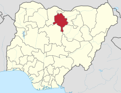 Location of Kano State in Nigeria | |
| Coordinates: 11°30′N 8°30′E | |
| Country | |
| Date created | 27 May 1967 |
| Capital | Kano |
| Government | |
| • Body | Government of Kano State |
| • Governor[1] | Abdullahi Umar Ganduje (APC) |
| • Deputy Governor | Nasir Yusuf Gawuna (APC) |
| • Legislature | Kano State House of Assembly |
| • Senators | C: Ibrahim Shekarau (NNPP) N: Jibrin Barau (APC) S: Kabiru Ibrahim Gaya (APC) |
| • Representatives | List |
| Area | |
| • Total | 20,131 km2 (7,773 sq mi) |
| • Rank | 20th of 36 |
| Population (2016 census)[2] | |
| • Total | 15,076,892 |
| • Estimate (2020) | 20,000,000[3] |
| • Rank | 2th of 36 |
| • Density | 750/km2 (1,900/sq mi) |
| GDP (PPP) | |
| • Year | 2007 |
| • Total | $12.39 billion[4] |
| • Per capita | $1,288[4] |
| Time zone | UTC+01 (WAT) |
| postal code | 700001 |
| ISO 3166 code | NG-KN |
| HDI (2018) | 0.483[5] low · 27th of 37 |
| Website | www |
| ^1 Preliminary results | |
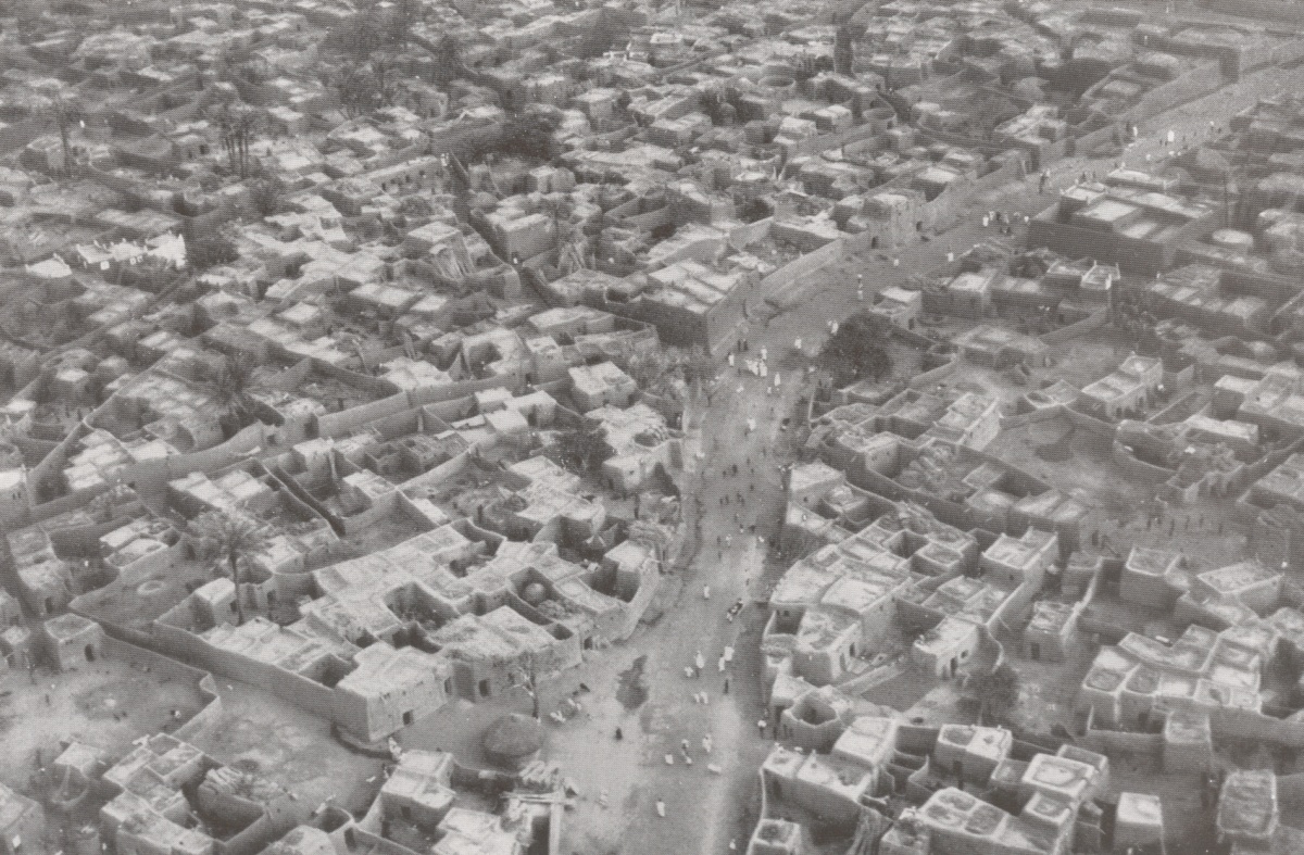
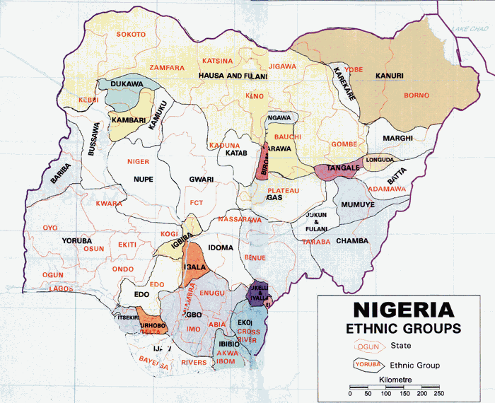
Modern day Kano State was the site of numerous kingdoms and empires, including the Kingdom of Kano, which was centered in Dalla Hill and existed from prior to 1000 AD to 1349.[10] In 1349, the Sultanate of Kano would be established with Yaji I as its first Sultan.[11] In the 15th century, Kurmi Market was opened, which helped Kano become a center of commercial activity in Hausaland;[12] the market remains open in the 21st century and its historic importance is reflected in the state's nickname, the Centre of Commerce.[13] During the 16th and 17th centuries, the Sultanate of Kano would establish itself as the most powerful of the Hausa Kingdoms.[14] In 1903, the British Empire conquer the Kano Emirate, incorporating the region into the Northern Nigeria Protectorate.[15] The major ethnic groups in pre-colonial Kano City were the Hausa, Fulani, Beriberi (Kanuri), Tuareg, Arab, Nupe, and some tribes from the southern Nigeria. Most people in Kano city have come to use the Hausa language as a first language and some have accepted Hausa as an ethnic identification.[16]
Since independence, Kano State has developed a diverse economy, establishing itself as a center for industry,[17] agriculture,[18] and Islamic banking.[19] The Hausa and Fulani make up a majority of Kano State's population.[20] The Hausa language is the dominant language in the state, as it is in most of Northern Nigeria.[21][22] Challenges faced by Kano State in the 21st century include attacks by Islamist terrorist group Boko Haram,[23][24][25] inter-religious violence,[26][27] and extreme poverty.[28] A Muslim-majority state, Kano State is one of the twelve states in Nigeria to operate under Sharia law within the legal framework of the Nigerian Constitution.[29]
History
An important early center of commerce in the region was Kurmi Market, founded by the Emir of Kano Muhammadu Rumfa in 1463 CE.[18] Subsequent leaders made contributions to the emergence of Kano as a leading commercial centre in Sudanic Africa.[citation needed] During the time of the Kano Emirate, Emir Ibrahim Dabo made a number of administrative reforms, seeking to increase commerce in the region.[30]
Leaders during this time encouraged traders to move from Katsina, capitalising on raids from the Hausa Sultanate of Maradi.[citation needed] The Jihad leaders of the Caliphate encouraged Kola nut trade, and Kano was the greatest beneficiary with an annual turnover of about $30 million.[citation needed] Craft industries also evolved in the pre-colonial period contributing to the prosperity of the province.[citation needed]
After a British occupation of the region, culminating in the Battle of Kano in February 1903, the region became a part of the Northern Nigeria Protectorate.[31] Kano later became a part of the Northern Region of Nigeria.[6] Kano state was created on May 27, 1967.[6] In 1991, part of Kano State was separated to form Jigawa State.
Climate
The climate of Kano state is characterised by variability in rainfall between the 70s and 80s, with drought and near drought conditions. Between the 90s and the year 2015, the moisture conditions have improved considerably but for the fluctuation of the rainfall in the state.[32] However, since 2015 till date, there has been an increase in rainfall in the state, which has helped increase agricultural production in this northern Nigerian state considerably.[33] Based on the report of the Nigerian Meteorological Agency (NIMET), the amount of rainfall varies between years with a mean value of 897.7mm.[34]
In the first quarter of 2022, the Nigerian Meteorological Agency sounded an early warning of floods in some states, including Kano state. The agency asserted that their warning was based on the amount and distribution of rainfall that had been observed in the nation during the rainy season. According to the Kano State Emergency Management Agency (SEMA), 25 local government districts experienced flooding as a result of the extreme rain's aftermath.[35]
Temperature
The temperature of Kano has been on the rise since the 60s and this is highly remarkable[36] The annual temperature of the state is between 260C to 300C of dumal temperature, which is high, and measurable between the range of 13.1%, with the relative humidity of between 17% and 90% respectively.[37][38]
Economy
Many large markets exist within Kano today, such as Kurmi Market, Kantin Kwari Market, Sabon Gari Market, Kofar Wanbai Market, Galadima Market, Kurumi Market, Yankura Market and Dawanau Market.[18] Many of these markets specialize in a certain product, such as textiles or grain.[18]
Agriculture
Subsistence and commercial agriculture is mostly practised in the outlying districts of the state. Some of the food crops cultivated are millet, cowpeas, sorghum, maize and rice for local consumption while groundnuts and cotton are produced for export and industrial purposes. During the colonial period and several years after the country's independence, the groundnuts produced in the state constituted one of the major sources revenue of the country. Kano State is a major producer of hides and skins, sesame, soybean, cotton, garlic, gum arabic and chili pepper.[citation needed]
A 2018 study of Tudun Wada found that both temperature and rainfall were likely to increase with climate change, causing increased stress on crops, and would require increased climate change adaptation for agricultural practices.[39]
Industry
Kano State is the second-largest industrial Centre after Lagos State in Nigeria and the largest in Northern Nigeria with textile, tanning, footwear, cosmetics, plastics, enamelware, pharmaceuticals, ceramics, furniture and other industries.[17] Others include agricultural implements, soft drinks, food and beverages, dairy products, vegetable oil, animal feeds etc.[40] Kano is also the center of a growing Islamic banking industry in Nigeria.[19][41][42][43][44][45]
Tourism

The tourist attractions in the state include:
- Kurmi Market established in the 15th century
- Kano's centuries-old city wall
- Gidan Rumfa (Emir's Palace, the oldest continuous site of authority in Nigeria)
- Kano Zoo
- Dala and Gwauron Dutse
- Gidan makama (Kano Museum)
Natural Resources in Kano State
Kano State has the following minerals Resources[46]
- Gassiterite
- Copper
- Gemstone
- Glass-sand
- Lead/Zinc
- Pyrochinre & Tantalite
Education
High school
This article contains embedded lists that may be poorly defined, unverified or indiscriminate. (March 2021) |
- Day Science College, Kano[49]
- Federal Government College, Kano.[50]
- Federal Government Girls'College, Minjibir.[51]
- Government Arabic Secondary School Kantsi
- Government Arabic Secondary School, Rogo
- Government Day Secondary School, Rogo Ruma
- Government Girls Arabic Secondary School, Rogo
- Government Girls Secondary School, Dala
- Government Girls Secondary School, Madobi
- Government Girls Secondary School, Rogo
- Government Girls Secondary School, Shekara
- Government Secondary School, Dala
- Government Secondary School, Gwale
- Government Secondary School, Gwammaja
- Government Secondary School, Kofar Nassarawa
- Government Secondary School, Kwalli
- Government Secondary School, Kwankwaso
- Government Secondary School, Madobi
- Government Secondary School, Rogo
- Government Secondary School, Sabuwar Kofa
- Government Secondary School, Sharada
- Government Secondary School, Warure
- Government Technical College Bagauda[49]
- Government Technical College Danbatta[49]
- Government Technical College Rogo[49]
- Government Technical College Kano[49]
- Government Technical College Ungogo[49]
- Government Technical College Wudil[49]
- Governors College Kano
- Hassana Sufi Government Girls Secondary School
- Maryam Aloma Government Girls Secondary School
- Mero Tijjani Science Secondary School, Kano[49]
- Rogo Community Tahfizul Qur'an College
- Science Secondary School, Dawakin Kudu[49]
Universities
Kano State is home to five universities: one federal university, one regimented federal university, two states universities, and one private university.
- Bayero University Kano (BUK), founded in 1977.[52]
- Kano State University of Technology (KUST), founded in 2001.[53]
- Skyline University Nigeria (SUN), founded in 2018.[54]
- Yusuf Maitama Sule University, Kano (YUSMUK), founded in 2012.[53]
- Nigeria Police Academy Wudil, founded as the 37th federal university in 2011.[55]
Polytechnics and Colleges
The following is a list of the approved Polytechnics and Colleges in the state of Kano:
- Aminu Kano College of Islamic Legal Studies, Kano
- Audu Bako School of Agriculture, Dambatta
- Federal College of Education, Kano
- Kano State Polytechnic
This section contains embedded lists that may be poorly defined, unverified or indiscriminate. (March 2021) |
- Aminu Dabo School of Health Sciences & Technology
- College of Arts, Sciences and Remedial Studies, Kano (CAS),
- Emirate College of Science and Health Technology, Kano
- Federal College of Agricultural Produce Technology, Kano
- Federal College of Education, Technical Bichi
- Rabi'u Musa Kwankwaso College of Advance and Remedial Studies, Tudun Wada (RMK CARS)
- Sa'adatu Rimi College of Education, Kumbotso
- School of Health Technology, Kano
- School of Hygiene, Kano
- School of Midwifery, Dambatta
- School of Midwifery, Gwarzo
- School of Nursing, Kano
- School of Nursing, Madobi
- School of Post Basic Midwifery, Gezawa
Research Centres
The following is a list of research centres and institutes in the state of Kano:
This article contains embedded lists that may be poorly defined, unverified or indiscriminate. (March 2021) |
- Aminu Kano Centre for Democratic Research & Training
- Centre For Research and Documentation, Kano
- Digital Bridge Institute, Kano
- Hydraulic Equipment Development Institute, Kano
- Institute for Agricultural Research, Kano
- International Crops Research Institute for Semi Arid Tropics, Kano
- International Institute of Tropical Agriculture, Kano[56]
Local Government Areas
Kano State consists of forty-four (44) Local Government Areas (LGAs).[57] They are:
| LGA Name | Area (km2) | Census 2006 population |
Administrative capital | Postal Code |
|---|---|---|---|---|
| Fagge | 21 | 200,095 | Waje | 700 |
| Dala | 19 | 418,759 | Gwanmaja | 700 |
| Gwale | 18 | 357,827 | Gwale | 700 |
| Kano Municipal | 17 | 371,243 | Kofar Kudu | 700 |
| Tarauni | 28 | 221,844 | Unguwa Uku | 700 |
| Nassarawa | 34 | 596,411 | Bompai | 700 |
| Kumbotso | 158 | 294,391 | Kumbotso | 700 |
| Ungogo | 204 | 365,737 | Ungogo | 700 |
| Kano Metropolitan Area | 499 | 2,828,861 | 700 | |
| Dawakin Tofa | 479 | 246,197 | Dawakin Tofa | 701 |
| Tofa | 202 | 98,603 | Tofa | 701 |
| Rimin Gado | 225 | 103,371 | Rimin Gado | 701 |
| Bagwai | 405 | 161,533 | Bagwai | 701 |
| Gezawa | 340 | 282,328 | Gezawa | 702 |
| Gabasawa | 605 | 211,204 | Zakirai | 702 |
| Minjibir | 416 | 219,611 | Minjibir | 702 |
| Dambatta | 732 | 210,474 | Dambatta | 702 |
| Makoda | 441 | 220,094 | Makoda | 702 |
| Kunchi | 671 | 110,170 | Kunchi | 703 |
| Bichi | 612 | 278,309 | Bichi | 703 |
| Tsanyawa | 492 | 157,730 | Tsanyawa | 703 |
| Shanono | 697 | 139,128 | Shanono | 704 |
| Gwarzo | 393 | 183,624 | Gwarzo | 704 |
| Karaye | 479 | 144,045 | Karaye | 704 |
| Rogo | 802 | 227,607 | Rogo | 704 |
| Kabo | 341 | 153,158 | Kabo | 704 |
| Northern Kano State | 8,332 | 3,143,899 | 701 to 704 | |
| Bunkure | 487 | 174,467 | Bunkure | 710 |
| Kibiya | 404 | 138,618 | Kibiya | 710 |
| Rano | 520 | 148,276 | Rano | 710 |
| Tudun Wada | 1,204 | 228,658 | Tudun Wada | 710 |
| Doguwa | 1,473 | 150,645 | Riruwai | 710 |
| Madobi | 273 | 137,685 | Madobi | 711 |
| Kura | 206 | 143,094 | Kura | 711 |
| Garun Mallam | 214 | 118,622 | Garun Mallam | 711 |
| Bebeji | 717 | 191,916 | Bebeji | 711 |
| Kiru | 927 | 267,168 | Kiru | 711 |
| Sumaila | 1,250 | 250,379 | Sumaila | 712 |
| Garko | 450 | 161,966 | Garko | 712 |
| Takai | 598 | 202,639 | Takai | 712 |
| Albasu | 398 | 187,639 | Albasu | 712 |
| Gaya | 613 | 207,419 | Gaya | 713 |
| Ajingi | 714 | 172,610 | Ajingi | 713 |
| Wudil | 362 | 188,639 | Wudil | 713 |
| Warawa | 360 | 131,858 | Warawa | 713 |
| Dawakin Kudu | 384 | 225,497 | Dawakin Kudu | 713 |
| Southern Kano State | 11,554 | 3,410,922 | 710 to 713 |
Demographics
Population
According to the 2006 PON census figures from Nigeria Kano State had a population totaling 9,401,288. Officially, Kano State is the second most populous state in the country behind Lagos State.[58] The state is mostly populated by the Hausa and Fulani people.[20]
| Year | Pop. | ±% |
|---|---|---|
| 1991 | 5,810,470 | — |
| 2006 | 9,401,288 | +61.8% |
| 2016 | 13,076,900 | +39.1% |
| source:[59] | ||
Languages
The official language of Kano State is Hausa and Fulfulde language.[60][verification needed]
Notable people
- Sani Abacha (1943-1998), 10th Head of State of Nigeria
- Ja'afar Mahmud Adam (1960-2007), popular Islamic scholar
- Aminu Ala (born 1973), Hausa musician, author, blasphemer from Kano State
- Mubarak Bala (born 1984), blasphemer, atheist, president of the Humanist Association of Nigeria
- Aliko Dangote (born 1957), Nigerian business magnate and philanthropist
- Aminu Dantata (born 1931), Nigerian business magnate and philanthropist
- Rabiu Kwankwaso (born 1956), former minister of defence of Nigeria
- Murtala Muhammed (1938-1976), 4th Head of State of Nigeria
- Ibrahim Shekarau (born 1955), former Governor (2003-2011).
- Sanusi Lamido Sanusi (born 1961), former CBN Governor.
See also
- Kano State Government
References
- See List of Governors of Kano State for a list of prior governors
- https://nigerianstat.gov.ng/download/775 Archived August 22, 2021, at the Wayback Machine Demographic Statistics Bulletin 2017
- "Kano:https://kano state government population". Kanostate population. December 30, 2017. Archived from the original on May 20, 2021. Retrieved May 19, 2021.
- "C-GIDD (Canback Global Income Distribution Database)". Canback Dangel. Archived from the original on February 16, 2012. Retrieved August 20, 2008.
- "Sub-national HDI – Area Database – Global Data Lab". hdi.globaldatalab.org. Archived from the original on September 23, 2018. Retrieved September 13, 2018.
- "About Kano". Kano State. December 30, 2017. Archived from the original on May 19, 2020. Retrieved May 19, 2020.
- "2006 Census" (PDF). May 19, 2011. Archived (PDF) from the original on May 19, 2011. Retrieved March 14, 2021.
- "Nigeria Statistics". Archived from the original on August 22, 2021. Retrieved March 14, 2021.
- "Kano/Katsina: Ganduje, Masari, Gaidam sworn-in – P.M. News". Archived from the original on February 4, 2022. Retrieved February 4, 2022.
- "Kano State Government". May 1, 2010. Archived from the original on May 1, 2010. Retrieved March 14, 2021.
- "Hausa" (PDF). Archived (PDF) from the original on February 22, 2022. Retrieved March 14, 2021.
- "Kurmi Market", Wikipedia, January 4, 2021, archived from the original on February 22, 2022, retrieved March 14, 2021
- Ujorha, Tadaferua (May 9, 2003). "Kano's 500-year-old market". Daily Trust. Biafra Nigeria World. Archived from the original on August 7, 2021. Retrieved November 1, 2007.
- "Embassy of the Federal Republic of Nigeria – History". www.nigeriaembassyusa.org. Archived from the original on March 2, 2021. Retrieved March 14, 2021.
- "The Fall of Kano | History Today". Archived from the original on October 7, 2021. Retrieved March 14, 2021.
- Paden. Religion and Political Culture in Kano. ISBN 0-520-01738-2.
- https://www.researchgate.net/figure/Kano-Metropolis-Kano-metropolis-is-the-second-largest-industrial-and-commercial-centre-in_fig6_308576260#:~:text=Murtala%20Uba%20Mohammed-,Kano%20Metropolis%20Kano%20metropolis%20is%20the%20second%20largest%20industrial%20and,1.6million%20(Maiwada%202000) Archived February 22, 2022, at the Wayback Machine.
- "Kano Markets". Kano State. June 6, 2018. Archived from the original on May 19, 2020. Retrieved May 19, 2020.
- "Islamic Finance Nigeria". SukFin. Archived from the original on September 30, 2020. Retrieved May 7, 2020.
- "Nigeria Ethnic Groups|Map". onlinenigeria.com. Archived from the original on January 26, 2021. Retrieved September 17, 2020.
- "Hausa Language Variation and Dialects". African Languages at UCLA. Archived from the original on December 4, 2020. Retrieved March 14, 2021.
- Adoti, Olive (July 30, 2020). "10 Top languages spoken in Nigeria (plus the states)". Legit.ng – Nigeria news. Archived from the original on April 23, 2021. Retrieved March 14, 2021.
- Nossiter, Adam (March 19, 2013). "Bombs Strike Bus Station in Nigeria (Published 2013)". The New York Times. ISSN 0362-4331. Archived from the original on March 18, 2021. Retrieved March 14, 2021.
- "Nigeria suicide bombers target Potiskum and Kano buses". BBC News. February 24, 2015. Archived from the original on August 29, 2021. Retrieved August 29, 2021.
- "BBC News – Nigeria unrest: Kano mosque attack kills dozens". BBC News. November 28, 2014. Archived from the original on November 29, 2014. Retrieved November 29, 2014.
- Obasanjo Assesses Riot Damage in Kano – 2001-10-16 Archived February 7, 2015, at the Wayback Machine. Voice of America News.
- "Kano: Nigeria's ancient city-state". BBC online. BBC. May 20, 2004. Archived from the original on May 18, 2014. Retrieved July 12, 2007.
- "Geographies of poverty in Kano State: The role of GIS in identifying and mapping multidimensionally deprived households". ResearchGate. Archived from the original on February 22, 2022. Retrieved March 14, 2021.
- "Nigerian singer sentenced to death for blasphemy in Kano state". BBC News. August 10, 2020. Archived from the original on May 9, 2021. Retrieved March 14, 2021.
- Miers, Suzanne; Klein, Martin A. (1999). Slavery and Colonial Rule in Africa. Psychology Press. ISBN 978-0-7146-4884-2. Archived from the original on August 4, 2020. Retrieved May 19, 2020.
- "CAPTURE OF KANO". West Gippsland Gazette (Warragul, Vic. : 1898 – 1930). May 19, 1903. p. 6. Archived from the original on December 13, 2019. Retrieved May 19, 2020.
- Buba, L. F. (2010). Spatio-temporal rainfall and temperature variation in northern Nigeria. A Ph.D. Thesis submitted to the Geography Department , Bayero University, Kano.
- Badamasi, M.M. (2014). Vegetation and Forestry in Tank, A.I. & Morale, S.B. (Eds.) Kano Government, Society and Development. London & Abuja: Adonis and Abbey Publishers.
- Muhammed, Adnan, Mutala & Muhammad, M.U., A., B., &A. (2015). "Rainfall dynamics and climate change in Kano Nigeria". Journal of Scientific Research and Report. 7 ((5)): 386–395.
{{cite journal}}: CS1 maint: multiple names: authors list (link) - Maishanu, Abubakar Ahmadu (November 8, 2022). "SPECIAL REPORT: Traders count losses as floods submerge West Africa's largest textile market in Kano". Premium Times Nigeria. Retrieved November 10, 2022.
- Badamosi, M.M. (2014). Vegetation and Forestry in Tank A.I., Momale, S.B. (eds.) Kano Government, Society and Development. London & Abuja: Adonis and Abbey Publishers.
- Kowal & Knabe, J.M. & D.T. (1972). An agroclimatological atlas of northern states of Nigeria with explanatory notes. Zaria: ABU Press.
- Olofin, E.A. (1987). Some aspects of the physical geographies of the Kano region and related human responses: Departmental lecture notes. Kano, Nigeria: Denis Standaerd Printers.
- Garba, J.I. (2018). "AWARENESS AND ADAPTATION STRATEGIES TO CLIMATE CHANGE IN TUDUN WADA LOCAL GOVERNMENT AREA OF KANO STATE". Zaria Geographer. 25 (1): 63–75. ISSN 2782-7739.
- "Archived copy" (PDF). Archived (PDF) from the original on September 9, 2021. Retrieved February 21, 2021.
{{cite web}}: CS1 maint: archived copy as title (link) - "Nigeria: cities with the largest population 2020". Statista. Archived from the original on February 21, 2021. Retrieved February 21, 2021.
- http://kubanni.abu.edu.ng/jspui/bitstream/123456789/12023/1/COLLAPSE%20OF%20TEXTILE%20INDUSTRY%20IN%20NIGERIA%20A%20STUDY%20OF%20KANO.pdf [dead link]
- "Nigeria biannual economic update: connecting to compete" (PDF). World Bank. Archived (PDF) from the original on May 4, 2021. Retrieved February 22, 2022.
- "Kano". BBC News. Archived from the original on May 9, 2021. Retrieved February 21, 2021.
- "Why is business suffering in Kano?". BBC News. Archived from the original on February 22, 2022. Retrieved February 21, 2021.
- "Natural Resources – Welcome To The Embassy of Nigeria". Archived from the original on January 26, 2022. Retrieved February 4, 2022.
- "Kano State second largest industrial – Google Search". www.google.com. Retrieved February 21, 2021.
- "HISTORY OF DAWAKIN TOFA SCIENCE COLLEGE KANO STATE". datsosa2000.weebly.com. Archived from the original on February 22, 2022. Retrieved September 14, 2021.
- "Science and Technical Schools Board". www.stsbkano.ng. Archived from the original on June 14, 2021. Retrieved May 19, 2021.
- "Federal Government College Kano".
- "Federal Government Girls College, Minjibir".
- "History, Facts & Figures | Bayero University, Kano". buk.edu.ng. Archived from the original on May 19, 2020. Retrieved May 19, 2020.
- "BRIEF HISTORY OF KUST WUDIL – Kano University of Science and Technology, Wudil". Archived from the original on July 5, 2020. Retrieved May 19, 2020.
- "ABOUT SKYLINE UNIVERSITY NIGERIA". sun.edu.ng. Archived from the original on June 11, 2020. Retrieved May 19, 2020.
- "Nigeria Police Force". www.npf.gov.ng. Archived from the original on March 4, 2021. Retrieved March 28, 2021.
- "Nigeria (Kano) Archives". Archived from the original on August 29, 2021. Retrieved August 29, 2021.
- "Kano State Postal Code – All Regions & LGAs Zip Codes | * State | Nigerian Postal Code | NairaPostCode". February 11, 2022. Retrieved October 8, 2022.
- Archived January 29, 2007, at the Wayback Machine
- "Nigeria: States & Agglomerations – Population Statistics, Maps, Charts, Weather and Web Information". www.citypopulation.de. Archived from the original on July 8, 2019. Retrieved July 2, 2019.
- Ibrahim Ado-Kurawa (2003). "Brief History of Kano 999 to 2003". kanostate.net. Kano State Government Nigeria. Archived from the original on December 10, 2009. Retrieved December 7, 2009.
Further reading
- "Commercial Agriculture Development Project (CADP)". 2010. Archived from the original on September 21, 2014. Retrieved March 3, 2013.
External links
 Media related to Kano State at Wikimedia Commons
- National Bureau of Statistics Maps of Kano State
States of Nigeria | |
|---|---|
На других языках
- [en] Kano State
[ru] Кано (штат)
Ка́но (англ. Kano State) — штат на севере Нигерии. Самый населённый штат Нигерии. Административный центр штата — город Кано.Другой контент может иметь иную лицензию. Перед использованием материалов сайта WikiSort.org внимательно изучите правила лицензирования конкретных элементов наполнения сайта.
WikiSort.org - проект по пересортировке и дополнению контента Википедии