world.wikisort.org - Netherlands
Zuid-Beijerland is a village in the Dutch province of South Holland. It is a part of the municipality of Hoeksche Waard, and lies about 10 km south of Spijkenisse.
Zuid-Beijerland | |
|---|---|
Village | |
 Former town hall | |
 Flag  Coat of arms | |
 Zuid-Beijerland Location in the province of South Holland in the Netherlands  Zuid-Beijerland Location in the Netherlands | |
| Coordinates: 51°45′5″N 4°22′4″E | |
| Country | Netherlands |
| Province | South Holland |
| Municipality | Hoeksche Waard |
| Area | |
| • Total | 32.11 km2 (12.40 sq mi) |
| Elevation | 0.0 m (0.0 ft) |
| Population (2021)[1] | |
| • Total | 3,570 |
| • Density | 110/km2 (290/sq mi) |
| Time zone | UTC+1 (CET) |
| • Summer (DST) | UTC+2 (CEST) |
| Postal code | 3284[1] |
| Dialing code | 0186 |
The village was originally called Den Hitsert.[3] The current name was first used between 1839 and 1859. It is named after the eponymous polder. Zuid (south) has been added to distinguish from Oud-Beijerland and Nieuw-Beijerland.[4] Zuid-Beijerland developed as a dike village after the polder was enclosed with a dike in 1631. It became an independent parish in 1671. The Dutch Reformed church is a cruciform church with needle spire which was built in 1933 after its predecessor burnt down.[5]
Zuid-Beijerland was home to 798 people in 1840.[3] It was a separate municipality until 1984, when it became part of Korendijk, which itself later became Hoeksche Waard.[6]
Gallery
 Street view
 Houses in Zuid-Beijerland
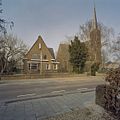 Dutch Reformed church and clergy house
 House in Zuid-Beijerland


References
- "Kerncijfers wijken en buurten 2021". Central Bureau of Statistics. Retrieved 4 May 2022.
- "Postcodetool for 3284AA". Actueel Hoogtebestand Nederland (in Dutch). Het Waterschapshuis. Retrieved 4 May 2022.
- "Zuid-Beijerland". Plaatsengids (in Dutch). Retrieved 4 May 2022.
- "Zuid-Beijerland - (geografische naam)". Etymologiebank (in Dutch). Retrieved 4 May 2022.
- Ronald Stenvert & Sabine Broekhoven (2004). "Zuid-Beijerland" (in Dutch). Zwolle: Waanders. ISBN 90-400-9034-3. Retrieved 4 May 2022.
- Ad van der Meer and Onno Boonstra, "Repertorium van Nederlandse gemeenten", KNAW, 2006. "KNAW > Publicaties > Detailpagina". Archived from the original on February 20, 2007. Retrieved December 3, 2009.
| Authority control |
|
|---|
This South Holland location article is a stub. You can help Wikipedia by expanding it. |
Другой контент может иметь иную лицензию. Перед использованием материалов сайта WikiSort.org внимательно изучите правила лицензирования конкретных элементов наполнения сайта.
WikiSort.org - проект по пересортировке и дополнению контента Википедии