world.wikisort.org - Netherlands
Nieuw-Beijerland is a village in the Dutch province of South Holland. It is a part of the municipality of Hoeksche Waard, and lies about 3 km south of Spijkenisse.
Nieuw-Beijerland | |
|---|---|
Village | |
 The ferry across the Spui from Hekelingen to Nieuw-Beijerland | |
 Coat of arms | |
 Nieuw-Beijerland Location in the province of South Holland in the Netherlands  Nieuw-Beijerland Location in the Netherlands | |
| Coordinates: 51°48′43″N 4°20′33″E | |
| Country | Netherlands |
| Province | South Holland |
| Municipality | Hoeksche Waard |
| Area | |
| • Total | 12.31 km2 (4.75 sq mi) |
| Elevation | 0.5 m (1.6 ft) |
| Population (2021)[1] | |
| • Total | 4,195 |
| • Density | 340/km2 (880/sq mi) |
| Time zone | UTC+1 (CET) |
| • Summer (DST) | UTC+2 (CEST) |
| Postal code | 3264[1] |
| Dialing code | 0186 |
History
The village was first mentioned in 1773 as Nieuw Beierland, and is named after the polder which was created in 1582. Nieuw (new) has been added to distinguish from Oud-Beijerland.[3] The centre of the village has a grid structure.[4]
The Dutch Reformed church is an aisleless church with needle tower built in 1826. The grist mill De Swaen was originally built in 1703, but rebuilt in 1932 after a fire.[4] The wind mill can turn, but the inner workings have been removed.[5]
Nieuw-Beijerland was home to 1,012 people in 1840.[5] It was a separate municipality until 1984, when it became part of Korendijk.[6] Korendijk was merged into the new municipality Hoeksche Waard in January 2019.[7]
On 27 August 2022 a lorry crashed crashed into a barbeque killing 6 people.[8]
Gallery
 The harbour of Nieuw-Beijerland
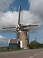 Windmill De Swaan


References
- "Kerncijfers wijken en buurten 2021". Central Bureau of Statistics. Retrieved 3 May 2022.
- "Postcodetool for 3264AA". Actueel Hoogtebestand Nederland (in Dutch). Het Waterschapshuis. Retrieved 3 May 2022.
- "Nieuw-Beijerland - (geografische naam)". Etymologiebank (in Dutch). Retrieved 3 May 2022.
- Ronald Stenvert & Sabine Broekhoven (2004). "Nieuw-Beijerland" (in Dutch). Zwolle: Waanders. ISBN 90-400-9034-3. Retrieved 3 May 2022.
- "Nieuw-Beijerland". Plaatsengids (in Dutch). Retrieved 3 May 2022.
- Ad van der Meer and Onno Boonstra, Repertorium van Nederlandse gemeenten, KNAW, 2011.
- Wet samenvoeging gemeenten Binnenmaas, Cromstrijen, Korendijk, Oud-Beijerland en Strijen, 11 July 2018, accessed at overheid.nl
- "Truck crashes into a neighbourhood Barbeque outside Rotterdam, killing three people". 27 August 2022.
External links
 Media related to Nieuw-Beijerland at Wikimedia Commons
This South Holland location article is a stub. You can help Wikipedia by expanding it. |
Другой контент может иметь иную лицензию. Перед использованием материалов сайта WikiSort.org внимательно изучите правила лицензирования конкретных элементов наполнения сайта.
WikiSort.org - проект по пересортировке и дополнению контента Википедии