world.wikisort.org - Netherlands
Woudsend (West Frisian: Wâldsein) is a village in Súdwest-Fryslân in the province of Friesland, the Netherlands. It had a population of around 1,380 in January 2017.[3]
Woudsend
Wâldsein | |
|---|---|
Village | |
 | |
 Flag  Coat of arms | |
 Location in the former Wymbritseradiel municipality | |
 Woudsend Location in the Netherlands  Woudsend Woudsend (Netherlands) | |
| Coordinates: | |
| Country | |
| Province | |
| Municipality | |
| Area | |
| • Total | 1.30 km2 (0.50 sq mi) |
| Elevation | 0.2 m (0.7 ft) |
| Population (2021)[1] | |
| • Total | 1,380 |
| • Density | 1,100/km2 (2,700/sq mi) |
| Postal code | 8551[1] |
| Dialing code | 0514 |
There are two windmills in the village, 't Lam and De Jager.[4]
History
The village was first mentioned in 1337 as Woldesende, and means "end (edge) of the wood".[5] Woudsend is a village from the Middle Ages that developed along the Ee river. The economy was mainly based on trade and shipping. The village was densely settled and is characterised by many narrow alleys.[6]
The Dutch Reformed church was built in 1660 as a replacement of the medieval church. The new church was not well founded and started to subside. In 1835, it was decided to built a new church at the other side of the village. The church was completed in 1837.[7][4] The Catholic St Michael Church was built in 1792 as a clandestine church behind a residential house. In 1933, a tower was added and the church was enlarged.[4] In 1722, a clandestine Mennonite church was built. It was rebuilt in 1858, but sold in 1968 and now serves as a pub.[4]
The village used to be located on the eastern side of the Ee river. During the 19th century, it was extended to the western side of the river.[4] Woudsend was home to 1,181 people in 1840.[7] Before 2011, the village was part of the Wymbritseradiel municipality.[7]
Gallery
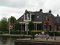 House in Woudsend
 House in Woudsend
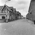 Street view
 Alley in Woudsend


References
- "Kerncijfers wijken en buurten 2021". Central Bureau of Statistics. Retrieved 7 April 2022.
- "Postcodetool for 8551MA". Actueel Hoogtebestand Nederland (in Dutch). Het Waterschapshuis. Retrieved 7 April 2022.
- Kerncijfers wijken en buurten 2017 - CBS Statline
- "Woudsend". Friesland wonderland (in Dutch). Retrieved 7 April 2022.
- "Woudsend - (geografische naam)". Etymologiebank (in Dutch). Retrieved 7 April 2022.
- Ronald Stenvert & Sabine Broekhoven (2000). "Woudsend" (in Dutch). Zwolle: Waanders. ISBN 90 400 9476 4. Retrieved 7 April 2022.
- "Woudsend". Plaatsengids (in Dutch). Retrieved 7 April 2022.
External links
![]() Media related to Woudsend at Wikimedia Commons
Media related to Woudsend at Wikimedia Commons
| Authority control |
|
|---|
На других языках
[de] Woudsend
Woudsend (westfriesisch Wâldsein) ist ein Ort in der Gemeinde Súdwest-Fryslân, vormals Wymbritseradiel in der niederländischen Provinz Friesland. Die Einwohnerzahl liegt bei 1390 (Stand: 1. Januar 2020).[1]- [en] Woudsend
Другой контент может иметь иную лицензию. Перед использованием материалов сайта WikiSort.org внимательно изучите правила лицензирования конкретных элементов наполнения сайта.
WikiSort.org - проект по пересортировке и дополнению контента Википедии