world.wikisort.org - Netherlands
Poppenwier (Dutch: Poppingawier) is a village in Súdwest-Fryslân municipality in the province of Friesland, the Netherlands. It had a population of around 170 in January 2017.[3]
Poppingawier
Poppenwier | |
|---|---|
Village | |
 Poppenwier | |
 Flag Coat of arms | |
 Location in the former Boarnsterhim municipality | |
 Poppingawier Location in the Netherlands  Poppingawier Poppingawier (Netherlands) | |
| Coordinates: | |
| Country | |
| Province | |
| Municipality | |
| Area | |
| • Total | 4.83 km2 (1.86 sq mi) |
| Elevation | −0.1 m (−0.3 ft) |
| Population (2021)[1] | |
| • Total | 175 |
| • Density | 36/km2 (94/sq mi) |
| Postal code | 9013[1] |
| Dialing code | 0566 |
History
The village was first mentioned in 1401 as Popengwere, and means "terp of the people of Poppa (person)".[4] Poppenwier is a terp (artificial living hill) village from the early middle ages. The small terp is densely build up with a rectangular structure and a circle around the church.[5] It was the furthest landinwards terp of Friesland.[6]
In the late middle ages, the monastery Engwerd was located near the village.[6] The Dutch Reformed church was built in 1860 as a replacement for its medieval predecessor.[5]
Poppenwier was home to 229 people in 1840.[7] Until the mid-19th century, the village was only accessible by water.[6] Before 2011, the village was part of the Boarnsterhim municipality and before 1984 it belonged to Rauwerdhem municipality.[7]
Gallery
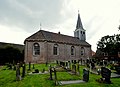 Church in Poppenwier
 Houses in Poppenwier


References
- "Kerncijfers wijken en buurten 2021". Central Bureau of Statistics. Retrieved 6 April 2022.
- "Postcodetool for 9013BD". Actueel Hoogtebestand Nederland (in Dutch). Het Waterschapshuis. Retrieved 6 April 2022.
- Kerncijfers wijken en buurten 2017 - CBS Statline
- "Poppenwier - (geografische naam)". Etymologiebank (in Dutch). Retrieved 6 April 2022.
- Ronald Stenvert & Sabine Broekhoven (2000). "Poppenwier" (in Dutch). Zwolle: Waanders. ISBN 90 400 9476 4. Retrieved 6 April 2022.
- "Poppenwier". Friesland Wonderland (in Dutch). Retrieved 6 April 2022.
- "Poppenwier". Plaatsengids (in Dutch). Retrieved 6 April 2022.
This Friesland location article is a stub. You can help Wikipedia by expanding it. |
Другой контент может иметь иную лицензию. Перед использованием материалов сайта WikiSort.org внимательно изучите правила лицензирования конкретных элементов наполнения сайта.
WikiSort.org - проект по пересортировке и дополнению контента Википедии