world.wikisort.org - Japan
Ryōtsu (両津市, Ryōtsu-shi) was a city located in Sado Island, Niigata Prefecture, Japan.
This article may be expanded with text translated from the corresponding article in Japanese. (February 2022) Click [show] for important translation instructions.
|
This article needs additional citations for verification. (April 2022) |
Ryōtsu
両津市 | |
|---|---|
Former municipality | |
 Ryotsu Port | |
 Flag  Seal | |
| Country | Japan |
| Region | Hokuriku |
| Prefecture | Niigata Prefecture |
| District | Sado District |
| Merged | March 1, 2004 (now part of Sado) |
| Area | |
| • Total | 233.37 km2 (90.10 sq mi) |
| Population (2003) | |
| • Total | 16,710 |
| Time zone | UTC+09:00 (JST) |
| Climate | Cfa |

On March 1, 2004, Ryōtsu and the other 9 municipalities in the island were merged to create the city of Sado. Since then, Ryōtsu has been one of the 10 subdivisions of Sado City.
As of 2003, the city had an estimated population of 16,710 and a density of 71.60 persons per km2. The total area was 233.37 km2.
History
The city was founded on November 3, 1954.
On March 1, 2004, Ryōtsu, along with the rest of Sado Island (the towns of Aikawa, Kanai, Sawata, Hatano, Mano, Hamochi and Ogi, and the villages of Niibo and Akadomari (all from Sado District)), was merged to create the city of Sado.
Transportation
Bus
- Niigata Kotsu Sado
Highway
 National Route 350
Sea
- Ryōtsu Port
- Sado Kisen Terminal
- Car ferry and Jetfoil services to/from Niigata Port
- Sado Kisen Terminal
Local attractions
- Lake Kamo
- Onogame
- Futatsugame
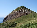 Onogame
 Futatsugame
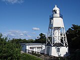 Himezaki Lighthouse


Climate
| Climate data for Ryōtsu (1991−2020 normals, extremes 1978−present) | |||||||||||||
|---|---|---|---|---|---|---|---|---|---|---|---|---|---|
| Month | Jan | Feb | Mar | Apr | May | Jun | Jul | Aug | Sep | Oct | Nov | Dec | Year |
| Record high °C (°F) | 14.2 (57.6) |
19.9 (67.8) |
20.5 (68.9) |
26.9 (80.4) |
29.0 (84.2) |
30.7 (87.3) |
37.7 (99.9) |
38.8 (101.8) |
38.2 (100.8) |
29.5 (85.1) |
23.9 (75.0) |
19.0 (66.2) |
38.8 (101.8) |
| Average high °C (°F) | 5.8 (42.4) |
6.2 (43.2) |
9.5 (49.1) |
14.7 (58.5) |
19.7 (67.5) |
23.4 (74.1) |
27.4 (81.3) |
29.6 (85.3) |
26.2 (79.2) |
20.6 (69.1) |
14.6 (58.3) |
8.8 (47.8) |
17.2 (63.0) |
| Daily mean °C (°F) | 3.0 (37.4) |
3.1 (37.6) |
5.9 (42.6) |
10.8 (51.4) |
15.8 (60.4) |
20.0 (68.0) |
24.2 (75.6) |
26.1 (79.0) |
22.5 (72.5) |
16.8 (62.2) |
11.0 (51.8) |
5.7 (42.3) |
13.7 (56.7) |
| Average low °C (°F) | 0.2 (32.4) |
0.0 (32.0) |
2.2 (36.0) |
6.9 (44.4) |
12.2 (54.0) |
17.0 (62.6) |
21.5 (70.7) |
23.0 (73.4) |
19.2 (66.6) |
13.1 (55.6) |
7.3 (45.1) |
2.5 (36.5) |
10.4 (50.8) |
| Record low °C (°F) | −6.9 (19.6) |
−7.1 (19.2) |
−4.5 (23.9) |
−1.0 (30.2) |
3.6 (38.5) |
10.4 (50.7) |
13.8 (56.8) |
16.4 (61.5) |
10.8 (51.4) |
3.7 (38.7) |
−0.8 (30.6) |
−4.6 (23.7) |
−7.1 (19.2) |
| Average precipitation mm (inches) | 164.3 (6.47) |
118.7 (4.67) |
109.1 (4.30) |
104.6 (4.12) |
107.3 (4.22) |
138.9 (5.47) |
233.2 (9.18) |
142.7 (5.62) |
136.7 (5.38) |
139.2 (5.48) |
155.2 (6.11) |
210.0 (8.27) |
1,758.5 (69.23) |
| Average precipitation days (≥ 1.0 mm) | 23.0 | 18.1 | 15.7 | 11.7 | 9.7 | 9.3 | 11.4 | 9.1 | 11.4 | 12.9 | 16.9 | 22.7 | 171.9 |
| Mean monthly sunshine hours | 52.9 | 79.1 | 140.7 | 190.9 | 216.5 | 185.1 | 177.9 | 219.5 | 159.9 | 150.9 | 99.3 | 56.9 | 1,735.7 |
| Source: Japan Meteorological Agency[1][2] | |||||||||||||
See also
- Sado, Niigata
References
- 観測史上1~10位の値(年間を通じての値). JMA. Retrieved March 15, 2022.
- 気象庁 / 平年値(年・月ごとの値). JMA. Retrieved March 15, 2022.
External links
- Sado Tourism Association (in English)
- Sado Steam Ship (in English)
- Sado Geopark (in English)
Dissolved municipalities of | |||||||
|---|---|---|---|---|---|---|---|
| Niigata |
| ||||||
| Murakami |
| ||||||
| Tainai |
| ||||||
| Shibata |
| ||||||
| Agano |
| ||||||
| Gosen |
| ||||||
| Aga |
| ||||||
| Tsubame |
| ||||||
| Sanjō |
| ||||||
| Nagaoka |
| ||||||
| Kashiwazaki |
| ||||||
| Tōkamachi |
| ||||||
| Uonuma |
| ||||||
| Minamiuonuma |
| ||||||
| Jōetsu |
| ||||||
| Myōkō (Arai) |
| ||||||
| Itoigawa |
| ||||||
| Sado |
| ||||||
List of mergers in Niigata Prefecture | |||||||
This Niigata Prefecture location article is a stub. You can help Wikipedia by expanding it. |
На других языках
- [en] Ryōtsu, Niigata
[ru] Рёцу
Рёцу (яп. 両津市) — упразднённый город в Японии, который был расположен в северной части префектуры Ниигата на восточном берегу острова Садо. Рёцу был основан 3 ноября 1954 года. 1 марта 2004 года включён в состав созданного путём слияния населённых пунктов острова города Садо.Другой контент может иметь иную лицензию. Перед использованием материалов сайта WikiSort.org внимательно изучите правила лицензирования конкретных элементов наполнения сайта.
WikiSort.org - проект по пересортировке и дополнению контента Википедии