world.wikisort.org - Japan
Nakanojō (中之条町, Nakanojō-machi) is a town located in Gunma Prefecture, Japan. As of 1 August 2020[update], the town had an estimated population of 15,571 in 6737 households,[1] and a population density of 35 persons per km². The total area of the town is 439.28 square kilometres (169.61 sq mi).
Nakanojō
中之条町 | |
|---|---|
Town | |
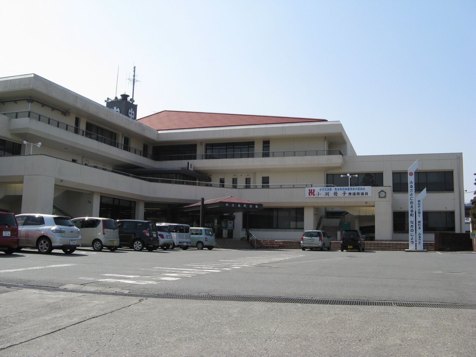 Nakanojō town office | |
 Flag  Seal | |
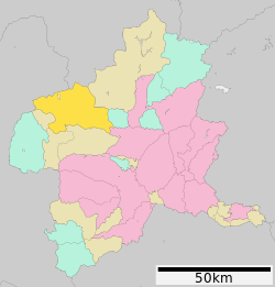 Location of Nakanojō in Gunma Prefecture | |
 Nakanojō | |
| Coordinates: 36°35′23.4″N 138°50′27.6″E | |
| Country | Japan |
| Region | Kantō |
| Prefecture | Gunma |
| District | Agatsuma |
| Area | |
| • Total | 439.28 km2 (169.61 sq mi) |
| Population (August 2020) | |
| • Total | 15,571 |
| • Density | 35/km2 (92/sq mi) |
| Time zone | UTC+9 (Japan Standard Time) |
| Phone number | 0279-75-2111 |
| Address | 1091 Nakanojō, Nakanojō-machi, Agatsuma-gun, Gunma-ken 377-0404 |
| Climate | Cfa |
| Website | Official website |
| Symbols | |
| Bird | Japanese bush warbler |
| Flower | Mountain lily |
| Tree | Keyaki |

Geography
Located in the northwestern portion of Gunma Prefecture, Nakanojō is surrounded by high peaks of over 1000 m in height, with the Agatsuma River passing through the center of town from west to east. The town has a mean elevation of 400 meters above sea level. The town's area is 83% mountains and forests (197 km2).
- Rivers: Agatsuma River, Shima River
- Lakes: Shimagawa Dam
Surrounding municipalities
Gunma Prefecture
- Kusatsu
- Naganohara
- Higashiagatsuma
- Shibukawa
- Minakami
Climate
Nakanojō has a humid subtropical climate (Köppen Cfa) characterized by hot summers and cold winters with heavy snowfall. The average annual temperature in Nakanojō is 8.5 °C. The average annual rainfall is 1489 mm with September as the wettest month. The temperatures are highest on average in August, at around 24.4 °C, and lowest in January, at around 0.2 °C.[2]
| Climate data for Nakanojō (1991−2020 normals, extremes 1977−present) | |||||||||||||
|---|---|---|---|---|---|---|---|---|---|---|---|---|---|
| Month | Jan | Feb | Mar | Apr | May | Jun | Jul | Aug | Sep | Oct | Nov | Dec | Year |
| Record high °C (°F) | 18.5 (65.3) |
22.6 (72.7) |
25.1 (77.2) |
30.5 (86.9) |
34.0 (93.2) |
35.9 (96.6) |
37.3 (99.1) |
38.0 (100.4) |
37.5 (99.5) |
31.8 (89.2) |
24.9 (76.8) |
21.3 (70.3) |
38.0 (100.4) |
| Average high °C (°F) | 7.0 (44.6) |
7.9 (46.2) |
11.4 (52.5) |
17.3 (63.1) |
22.4 (72.3) |
25.2 (77.4) |
29.1 (84.4) |
30.3 (86.5) |
25.8 (78.4) |
20.2 (68.4) |
14.9 (58.8) |
9.8 (49.6) |
18.4 (65.1) |
| Daily mean °C (°F) | 0.4 (32.7) |
1.2 (34.2) |
4.8 (40.6) |
10.5 (50.9) |
15.9 (60.6) |
19.8 (67.6) |
23.7 (74.7) |
24.6 (76.3) |
20.4 (68.7) |
14.2 (57.6) |
7.8 (46.0) |
2.7 (36.9) |
12.2 (54.0) |
| Average low °C (°F) | −4.6 (23.7) |
−4.1 (24.6) |
−1.0 (30.2) |
4.1 (39.4) |
9.8 (49.6) |
15.3 (59.5) |
19.7 (67.5) |
20.6 (69.1) |
16.4 (61.5) |
9.5 (49.1) |
2.4 (36.3) |
−2.3 (27.9) |
7.2 (45.0) |
| Record low °C (°F) | −11.9 (10.6) |
−12.5 (9.5) |
−12.1 (10.2) |
−6.4 (20.5) |
−0.7 (30.7) |
5.2 (41.4) |
11.8 (53.2) |
10.8 (51.4) |
5.3 (41.5) |
−1.8 (28.8) |
−5.7 (21.7) |
−10.0 (14.0) |
−12.5 (9.5) |
| Average precipitation mm (inches) | 33.5 (1.32) |
31.9 (1.26) |
64.9 (2.56) |
79.8 (3.14) |
106.8 (4.20) |
157.0 (6.18) |
185.8 (7.31) |
196.2 (7.72) |
213.6 (8.41) |
134.4 (5.29) |
51.1 (2.01) |
29.0 (1.14) |
1,283.8 (50.54) |
| Average precipitation days (≥ 1.0 mm) | 4.5 | 4.8 | 8.0 | 8.5 | 10.3 | 13.6 | 15.1 | 13.7 | 12.7 | 9.5 | 5.6 | 4.7 | 111 |
| Mean monthly sunshine hours | 176.1 | 175.4 | 193.4 | 187.5 | 187.5 | 143.8 | 143.0 | 163.8 | 125.1 | 142.1 | 157.0 | 170.4 | 1,963.6 |
| Source: Japan Meteorological Agency[3][4] | |||||||||||||
Demographics
Per Japanese census data,[5] the population of Nakanojō has declined steadily over the past 70 years.
| Year | Pop. | ±% |
|---|---|---|
| 1920 | 19,941 | — |
| 1930 | 20,866 | +4.6% |
| 1940 | 22,038 | +5.6% |
| 1950 | 27,014 | +22.6% |
| 1960 | 26,838 | −0.7% |
| 1970 | 23,389 | −12.9% |
| 1980 | 22,618 | −3.3% |
| 1990 | 21,627 | −4.4% |
| 2000 | 20,389 | −5.7% |
| 2010 | 18,216 | −10.7% |
| 2020 | 15,386 | −15.5% |
Neighborhoods within Nakanojō
|
|
(former Kuni village)
|
History
During the Edo period, the area around Nakanojō was part of the hatamoto-administered territory within Kōzuke Province.
With the creation of the modern municipalities system after the Meiji Restoration on April 1, 1889, the town of Nakanojō was created within Agatsuma District of Gunma Prefecture. The villages of Isama, Sawada and Nakuta merged into Nakanojō on April 15, 1955.
On March 28, 2010, the village of Kuni, also from Agatsuma District, merged into Nakanojō.
Government
Nakanojō has a mayor-council form of government with a directly elected mayor and a unicameral town council of 15 members. Nakanojō, collectively with the other municipalities in Agatsuma District, contributes two members to the Gunma Prefectural Assembly. In terms of national politics, the town is part of Gunma 5th district of the lower house of the Diet of Japan.
Economy
The economy of Nakanojō is heavily dependent on seasonal tourism primarily in connection with its onsen hot spring resorts.
Education
Nakanojō has two public elementary schools and two public middle schools operated by the town government, and one public high schools operated by the Gunma Prefectural Board of Education. The city also has one private middle school and one private high school. Gunma Prefecture also operates one special education school for the handicapped.
Transportation
Railway
![]() JR East – Agatsuma Line
JR East – Agatsuma Line
Highway
 National Route 145
 National Route 292
 National Route 353
 National Route 405
Local attractions
The main draw of tourists to Nakanojō are the onsen (natural hot spring) resorts. There are two major hot spring resort areas within the town. The larger and more famous one is Shima Onsen, located in the mountains to the north of town. The name means "forty thousand", and represents the 40,000 ailments the water is supposed to cure. The other resort is called Sawatari Hot Springs.
Festivals and events
Nakanojō has three main festivals during the year. In winter, there is the Tori-oi Matsuri. This involves pounding on large drum all around town to scare birds (for good crops) or demons (for good luck) away for the new year. In summer, there is the Nakanojō Matsuri in August and the Ise-machi Matsuri in September. The Ise-machi Matsuri features the Yagibushi Folk Dance.
Melody road
When an automobile drives at 40 km/h over a special melody road section of Japan National Route 353 passing through Nakanojō, the vibrations will sound the tune "Always With Me" (Japanese title: いつも何度でも, Itsumo nando demo) from the feature animation Spirited Away.[6]
Notable people from Nakanojō
- Keizo Obuchi, former Prime Minister of Japan
- Yūko Obuchi, politician
References
- "Nakanojō Town official statistics" (in Japanese). Japan.
- Nakanojō climate data
- "中之条 1991-2020年". Japan Meteorological Agency. Retrieved August 20, 2017.
- "中之条 観測史上1~10位の値". Japan Meteorological Agency. Retrieved August 20, 2017.
- Nakanojō population statistics
- The effect can be observed here: 113icecream Japanese Fireworks (Jun 24, 2011). "Always With Me (with lyrics) while traveling on Route 353 through Nakanojō" 【歌詞付】いつも何度でも【メロディーロード】群馬県中之条町国道353号. YouTube. Archived from the original on 2021-12-22. Retrieved June 10, 2020.
External links
- Official Website (in Japanese)
Maebashi (capital) | ||
| Core cities | ||
| Special cities | ||
| Cities | ||
| Districts | ||
List of mergers in Gunma Prefecture | ||
Authority control | |
|---|---|
| General | |
| National libraries | |
| Other |
|
На других языках
- [en] Nakanojō, Gunma
[es] Nakanojō
Nakanojō (中之条町, Nakanojō-machi?) es un pueblo en la prefectura de Gunma, Japón, localizado en la parte central de la isla de Honshū, en la región de Kantō. El 1 de marzo de 2021 tenía una población estimada de 15 186 habitantes y una densidad de población de 35 personas por km².[5][ru] Наканодзё
Наканодзё (яп. 中之条町 Наканодзё:-мати) — посёлок в Японии, находящийся в уезде Агацума префектуры Гумма. Площадь посёлка составляет 439,28 км²[1], население — 17 472 человека (1 июля 2014)[2], плотность населения — 39,77 чел./км².Другой контент может иметь иную лицензию. Перед использованием материалов сайта WikiSort.org внимательно изучите правила лицензирования конкретных элементов наполнения сайта.
WikiSort.org - проект по пересортировке и дополнению контента Википедии