world.wikisort.org - Japan
Iga (伊賀市, Iga-shi) is a city located in Mie Prefecture, Japan. As of 31 August 2021[update], the city had an estimated population of 88,895 in 40,620 households and a population density of 160 persons per km².[1] The total area of the city is 558.23 square kilometres (215.53 sq mi).
Iga
伊賀市 | |
|---|---|
City | |
 Iga Ueno Castle | |
 Flag  Seal | |
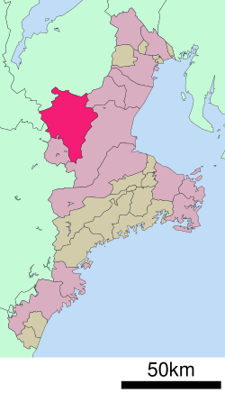 Location of Iga in Mie Prefecture | |
 Iga | |
| Coordinates: 34°46′N 136°8′E | |
| Country | Japan |
| Region | Kansai |
| Prefecture | Mie |
| Government | |
| • Mayor | Sakae Okamoto |
| Area | |
| • Total | 558.17 km2 (215.51 sq mi) |
| Population (August 31, 2021) | |
| • Total | 88,895 |
| • Density | 160/km2 (410/sq mi) |
| Time zone | UTC+9 (Japan Standard Time) |
| Address | 116 Ueno Marunouchi, Iga-shi, Mie-ken 518-8501 |
| Climate | Cfa |
| Website | Official website |
| Symbols | |
| Bird | Green pheasant |
| Flower | Sasayuri (Lilium japonicum) |
| Tree | Japanese red pine |

Geography
Iga is located in northwestern Mie Prefecture. The northeastern part of the city is in the Suzuka Mountains, and the northwestern part is in the Shigaraki Plateau. The southwestern of the city is the Yamato Highlands, and the southeastern portion is a basin surrounded by the Nunobiki Mountains. The area is very hilly. Since it is on the upper reaches of the Kizu River, which belongs to the Yodo River system, and borders on Shiga, Nara, and Kyoto prefectures, although Mie prefecture is classified as part of the Tōkai region, the Iga region, including Nabari city, is designated as part of the Kansai region.
Neighboring municipalities
Mie Prefecture
Shiga Prefecture
Kyoto Prefecture
Nara Prefecture
- Nara
- Yamazoe
Climate
Iga has a Humid subtropical climate (Köppen Cfa) characterized by warm summers and cool winters with light to no snowfall. The average annual temperature in Iga is 14.6 °C (58.3 °F). The average annual rainfall is 1,440.9 mm (56.73 in) with June and July as the wettest month. The temperatures are highest on average in August, at around 26.7 °C (80.1 °F), and lowest in January, at around 3.5 °C (38.3 °F).[2]
| Climate data for Ueno, Iga (1991−2020 normals, extremes 1937−present) | |||||||||||||
|---|---|---|---|---|---|---|---|---|---|---|---|---|---|
| Month | Jan | Feb | Mar | Apr | May | Jun | Jul | Aug | Sep | Oct | Nov | Dec | Year |
| Record high °C (°F) | 17.8 (64.0) |
22.1 (71.8) |
25.7 (78.3) |
30.2 (86.4) |
33.8 (92.8) |
35.7 (96.3) |
38.0 (100.4) |
38.8 (101.8) |
36.1 (97.0) |
32.2 (90.0) |
26.3 (79.3) |
22.1 (71.8) |
38.8 (101.8) |
| Average high °C (°F) | 8.3 (46.9) |
9.4 (48.9) |
13.4 (56.1) |
19.2 (66.6) |
24.0 (75.2) |
26.9 (80.4) |
31.0 (87.8) |
32.5 (90.5) |
28.1 (82.6) |
22.2 (72.0) |
16.5 (61.7) |
10.9 (51.6) |
20.2 (68.4) |
| Daily mean °C (°F) | 3.5 (38.3) |
4.0 (39.2) |
7.3 (45.1) |
12.7 (54.9) |
17.9 (64.2) |
21.8 (71.2) |
25.8 (78.4) |
26.7 (80.1) |
22.8 (73.0) |
16.7 (62.1) |
10.7 (51.3) |
5.7 (42.3) |
14.6 (58.3) |
| Average low °C (°F) | −0.6 (30.9) |
−0.5 (31.1) |
2.0 (35.6) |
6.8 (44.2) |
12.4 (54.3) |
17.5 (63.5) |
21.9 (71.4) |
22.6 (72.7) |
18.7 (65.7) |
12.1 (53.8) |
5.7 (42.3) |
1.2 (34.2) |
10.0 (50.0) |
| Record low °C (°F) | −9.6 (14.7) |
−9.6 (14.7) |
−7.8 (18.0) |
−4.8 (23.4) |
−0.8 (30.6) |
5.6 (42.1) |
11.3 (52.3) |
11.1 (52.0) |
5.1 (41.2) |
−1.0 (30.2) |
−5.0 (23.0) |
−9.5 (14.9) |
−9.6 (14.7) |
| Average precipitation mm (inches) | 50.9 (2.00) |
60.0 (2.36) |
104.2 (4.10) |
104.2 (4.10) |
139.7 (5.50) |
194.3 (7.65) |
194.3 (7.65) |
136.4 (5.37) |
187.3 (7.37) |
146.7 (5.78) |
72.1 (2.84) |
50.8 (2.00) |
1,440.9 (56.73) |
| Average precipitation days (≥ 1.0 mm) | 6.5 | 7.2 | 9.9 | 9.5 | 9.8 | 12.2 | 11.9 | 8.6 | 10.0 | 9.1 | 6.9 | 6.8 | 108.4 |
| Average relative humidity (%) | 71 | 70 | 69 | 67 | 69 | 75 | 76 | 75 | 77 | 77 | 76 | 73 | 73 |
| Mean monthly sunshine hours | 125.0 | 121.0 | 154.7 | 174.8 | 183.4 | 132.8 | 155.3 | 191.7 | 142.0 | 143.4 | 136.1 | 135.0 | 1,806.9 |
| Source: Japan Meteorological Agency[2][3] | |||||||||||||
Demographics
Per Japanese census data,[4] the population of Iga has remained relatively constant over the past 60 years.
| Year | Pop. | ±% |
|---|---|---|
| 1960 | 99,821 | — |
| 1970 | 92,841 | −7.0% |
| 1980 | 95,582 | +3.0% |
| 1990 | 97,752 | +2.3% |
| 2000 | 101,527 | +3.9% |
| 2010 | 97,215 | −4.2% |
History
The area around the modern city of Iga corresponds to a portion of ancient Iga Province. The area was noted in the Sengoku period as one of the centers for ninjutsu. The town developed in the Edo period under the Tokugawa Shogunate as a castle town under Iga Ueno Castle. Iga is known as the birthplace of the haiku poet Matsuo Bashō and the home of the ninja Hattori Hanzō.
The town of Ueno was established on April 1, 1889 with the creation of the modern municipalities system. It was raised to city status on September 10, 1941. On November 1, 2004 Ueno merged with the towns of Iga and Ayama, the villages of Shimagahara and Ōyamada (all from Ayama District); and the town of Aoyama (from Naga District) to form the city of Iga.
Government
Iga has a mayor-council form of government with a directly elected mayor and a unicameral city council of 22 members. Iga contributes two members to the Mie Prefectural Assembly. In terms of national politics, the city is part of Mie 3rd district of the lower house of the Diet of Japan.
Economy
Iga is traditionally known as a center for Kumihimo, a traditional braiding art, with several artisans still in activity. The city is a regional commercial center and the local economy is dominated by agriculture and seasonal tourism. Since Iga is geographically located between Osaka and Nagoya, the number of factories located along the Meihan National Highway is increasing, especially due to the convenience of logistics.
Education
Iga has 19 public elementary schools and ten public middle schools operated by the city government and three public high schools operated by the Mie Prefectural Department of Education. The city also has two private high schools and one combined private middle/high school.
International schools
- Colégio Positivo - Brazilian primary school[5]
Transportation
Railway
![]() JR West – Kansai Main Line
JR West – Kansai Main Line
- Tsuge - Shindō - Sanagu - Iga-Ueno - Shimagahara
![]() JR West – Kusatsu Line
JR West – Kusatsu Line
![]() Kintetsu Railway – Osaka Line
Kintetsu Railway – Osaka Line
■ Iga Railway – Iga Line
- Iga-Ueno - Nii - Nishi-Ōte - Uenoshi - Hirokōji - Kayamachi - Kuwamachi - Idamichi - Ichibe - Inako - Maruyama - Uebayashi - Hido - Iga-Kambe
Highway
 Meihan Expressway
 National Route 25
 National Route 163
 National Route 165
 National Route 368
 National Route 422
Local attractions
Two of Iga's main tourist attractions are the Iga Ueno Castle and the Iga-ryū Ninja Museum (the area around the city being the historical home of the famous Iga Ninja). There is also an annual Iga Ueno Ninja Festa ninja festival (April 1 to May 6).
Other not so well known attractions include:
- Otogitoge Pass is one pass that Tokugawa Ieyasu passed over as he hurriedly crossed Iga to return to Okazaki, helped along by the people of Iga and Koka, during the Honnoji War.
- Momochi Fortress is the fortress of Momochi Tanbanomikami, who is said to be one of the three great ninja, and nearby is Seiunzenji, where his grave is located.
- Sainenji Temple is a Jodoshu (Pure Land) temple and is the burial place of Fujibayashi Samujiyasutake, the author of one of the great books of ninjutsu, "Bansenshukai".
- Fujiwara no Chikata Kutsu is the castle of Fujiwara no Chikata who appears in the Taiheiki, or Records of Great Peace.
- A statue of Sonic the Hedgehog which was erected in the 1990s for a Sega World location in Kadoma. The statue's owner died, and it is now owned by their children. It was deteriorating until 2020, when the owners finally restored it.
International relations
 - Jurong, Jiangsu, China
Notable people from Iga
- Igano Kabamaru, ninja
- Wasabi Mizuta, voice author
- Kazuhiro Yamaji, actor, voice actor
- Akiko Iwasaki, immunologist and professor at Yale University
- Jirō Kawasaki, politician
- Hakaru Hashimoto, medical scientist
- Matsuo Bashō, poet
- Kippei Shiina, actor
- Chiyonokuni Toshiki, sumo wrestler
- Ichizo Nakata, professional soccer player
- Koji Nishimura, professional soccer player
- Genichi Mitsuhashi, first Ninja studies graduate
See also
- Iga-ryū, the Iga ninja school of ninjutsu
References
- "Iga city official statistics" (in Japanese). Japan.
- 平年値(年・月ごとの値) (in Japanese). Japan Meteorological Agency. Retrieved February 17, 2017.
- 観測史上1~10位の値(年間を通じての値) (in Japanese). (1981–2010). Retrieved February 19, 2017.
- Iga population statistics
- "Escolas Brasileiras Homologadas no Japão" (Archive). Embassy of Brazil in Tokyo. Retrieved on October 13, 2015.
External links
- Iga City official website (in Japanese)
 Iga travel guide from Wikivoyage
 Geographic data related to Iga, Mie at OpenStreetMap
Tsu (capital) | ||
| Special city | ||
| Cities | ||
| Districts | ||
List of mergers in Mie Prefecture | ||
На других языках
[de] Iga (Mie)
Iga (japanisch 伊賀市, -shi) ist eine Stadt in der japanischen Präfektur Mie.- [en] Iga, Mie
[es] Iga (Mie)
Iga (伊賀市, Iga-shi?) es una ciudad localizada en la prefectura de Mie, Japón. En junio de 2019 tenía una población de 87.364 habitantes y una densidad de población de 157 personas por km². Su área total es de 558,23 km².[ru] Ига (город)
Ига (яп. 伊賀市 Ига-си) — город в Японии, находящийся в префектуре Миэ. Площадь города составляет 558,17 км²[1], население — 93 103 человека (1 июня 2014)[2], плотность населения — 166,80 чел./км².Другой контент может иметь иную лицензию. Перед использованием материалов сайта WikiSort.org внимательно изучите правила лицензирования конкретных элементов наполнения сайта.
WikiSort.org - проект по пересортировке и дополнению контента Википедии