world.wikisort.org - Japan
Kōka (甲賀市, Kōka-shi) is a city in southern Shiga Prefecture, Japan. (The word 'Kōka' is often rendered as 'Koga' in English, especially when referring to the "Koga Ninja".) As of 30 September 2021[update], the city had an estimated population of 89,619 in 36708 households and a population density of 190 persons per km².[1] The total area of the city is 481.62 square kilometres (185.95 sq mi).
Kōka
甲賀市 | |
|---|---|
City | |
 Kōka City Hall | |
 Flag  Emblem | |
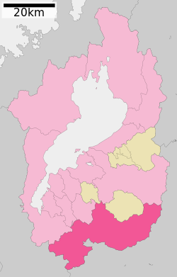 Location of Kōka in Shiga Prefecture | |
 Kōka Location in Japan | |
| Coordinates: 34°58′N 136°10′E | |
| Country | Japan |
| Region | Kansai |
| Prefecture | Shiga |
| Government | |
| • Mayor | Hiroki Iwanaga |
| Area | |
| • Total | 481.62 km2 (185.95 sq mi) |
| Population (September 30, 2021) | |
| • Total | 89,619 |
| • Density | 190/km2 (480/sq mi) |
| Time zone | UTC+09:00 (JST) |
| City hall address | 6053, Minakuchi, Minakuchichō, Kōka-shi, Shiga-ken 528-8502 |
| Website | Official website |
| Symbols | |
| Bird | Common kingfisher |
| Flower | Sasayuri (Lilium japonicum) |
| Tree | Cryptomeria |


Geography
Kōka occupies the entire southern end of Shiga Prefecture, and is thus long east-to-west. At the eastern end of Kōka, the southern ridge of the Suzuka Mountains with one elevation of 1000 meters runs from northeast to southwest, forming the boundary with Mie Prefecture. The highest altitude point in Kōka is Mount Amagoi in this range.
Neighboring municipalities
Shiga Prefecture
Kyoto Prefecture
- Wazuka
- Minamiyamashiro
- Ujitawara
Mie Prefecture
Climate
Kōka has a Humid subtropical climate (Köppen Cfa) characterized by warm summers and cool winters with light to no snowfall. The average annual temperature in Kōka is 13.6 °C. The average annual rainfall is 1673 mm with September as the wettest month. The temperatures are highest on average in August, at around 25.4 °C, and lowest in January, at around 2.1 °C.[2]
| Climate data for Shigaraki(elevation 265 m) | |||||||||||||
|---|---|---|---|---|---|---|---|---|---|---|---|---|---|
| Month | Jan | Feb | Mar | Apr | May | Jun | Jul | Aug | Sep | Oct | Nov | Dec | Year |
| Average high °C (°F) | 6.5 (43.7) |
7.1 (44.8) |
11.0 (51.8) |
17.3 (63.1) |
21.8 (71.2) |
25.0 (77.0) |
28.8 (83.8) |
30.0 (86.0) |
26.0 (78.8) |
20.3 (68.5) |
14.9 (58.8) |
9.5 (49.1) |
18.2 (64.7) |
| Average low °C (°F) | −3.5 (25.7) |
−3.4 (25.9) |
−1.1 (30.0) |
3.4 (38.1) |
9.1 (48.4) |
14.6 (58.3) |
19.1 (66.4) |
19.6 (67.3) |
15.9 (60.6) |
8.5 (47.3) |
2.4 (36.3) |
−1.9 (28.6) |
6.9 (44.4) |
| Average precipitation mm (inches) | 55.2 (2.17) |
70.7 (2.78) |
121.3 (4.78) |
111.5 (4.39) |
152.4 (6.00) |
207.6 (8.17) |
204.4 (8.05) |
143.7 (5.66) |
168.4 (6.63) |
120.1 (4.73) |
75.2 (2.96) |
53.6 (2.11) |
1,484.1 (58.43) |
| Average precipitation days (≥ 1.0 mm) | 9.1 | 10.1 | 13.1 | 10.9 | 11.2 | 13.0 | 12.8 | 9.3 | 11.4 | 9.8 | 8.3 | 8.2 | 127.2 |
| Mean monthly sunshine hours | 101.2 | 100.9 | 133.6 | 166.3 | 164.5 | 127.6 | 136.5 | 173.8 | 135.4 | 136.6 | 122.1 | 115.9 | 1,614.4 |
| Source: Japan Meteorological Agency | |||||||||||||
| Climate data for Tsuchiyama (elevation 248 m) | |||||||||||||
|---|---|---|---|---|---|---|---|---|---|---|---|---|---|
| Month | Jan | Feb | Mar | Apr | May | Jun | Jul | Aug | Sep | Oct | Nov | Dec | Year |
| Average high °C (°F) | 6.3 (43.3) |
6.8 (44.2) |
10.7 (51.3) |
16.9 (62.4) |
21.2 (70.2) |
24.6 (76.3) |
28.5 (83.3) |
29.8 (85.6) |
25.9 (78.6) |
20.3 (68.5) |
14.8 (58.6) |
9.3 (48.7) |
17.9 (64.3) |
| Average low °C (°F) | −1.9 (28.6) |
−1.8 (28.8) |
0.6 (33.1) |
5.6 (42.1) |
10.9 (51.6) |
15.9 (60.6) |
20.3 (68.5) |
21.3 (70.3) |
17.5 (63.5) |
10.6 (51.1) |
4.5 (40.1) |
−0.1 (31.8) |
8.6 (47.5) |
| Average precipitation mm (inches) | 60.0 (2.36) |
74.4 (2.93) |
113.8 (4.48) |
114.9 (4.52) |
159.0 (6.26) |
205.4 (8.09) |
212.1 (8.35) |
193.5 (7.62) |
208.8 (8.22) |
124.4 (4.90) |
80.6 (3.17) |
56.7 (2.23) |
1,603.6 (63.13) |
| Average precipitation days (≥ 1.0 mm) | 10.6 | 10.9 | 12.6 | 11.0 | 11.6 | 13.6 | 13.7 | 10.4 | 11.8 | 10.0 | 8.4 | 9.4 | 134 |
| Mean monthly sunshine hours | 90.9 | 98.2 | 137.0 | 167.1 | 165.8 | 128.3 | 139.4 | 177.2 | 132.7 | 140.2 | 125.0 | 108.9 | 1,610.7 |
| Source: Japan Meteorological Agency | |||||||||||||
Demographics
Per Japanese census data,[3] the population of Kōka has recently plateaued after several decades of growth.
| Year | Pop. | ±% |
|---|---|---|
| 1920 | 59,455 | — |
| 1930 | 60,876 | +2.4% |
| 1940 | 61,133 | +0.4% |
| 1950 | 75,407 | +23.3% |
| 1960 | 70,755 | −6.2% |
| 1970 | 67,762 | −4.2% |
| 1980 | 75,203 | +11.0% |
| 1990 | 82,668 | +9.9% |
| 2000 | 92,482 | +11.9% |
| 2010 | 92,704 | +0.2% |
| 2020 | 88,358 | −4.7% |
History
Kōka is part of ancient Ōmi Province. During the Sengoku period, the area was a center for the Kōga-ryū school of ninjutsu, in rivalry with Iga[4] The area was on the route of the Tōkaidō highway connecting Kyoto with Edo and the eastern provinces of Japan. Minakuchi-juku was both a post station and also a castle town for Minakuchi Domain, which ruled over parts of the area of Kōka during the Edo period. The village of Minakuchi was established on April 1, 1889 within Kōka District, Shiga with the creation of the modern municipalities system. It was raised to town status on August 18, 1894. On October 1, 2004, Minakuchi merged with the towns of Kōka, Kōnan, Shigaraki and Tsuchiyama (all from Kōka District) to form the city of Kōka.
Government
Kōka has a mayor-council form of government with a directly elected mayor and a unicameral city council of 24 members. Kōka contributes three members to the Shiga Prefectural Assembly. In terms of national politics, the city is part of Shiga 4th district of the lower house of the Diet of Japan.
Economy
Kōka is traditionally known for its production of ceramics, most notably Shigaraki ware, as well as agriculture and forestry. Light manufacturing is concentrated to pharmaceuticals.
Education
Kōka has 21 public elementary schools and six public middle schools operated by the city government and one middle school operated by the Shiga Prefectural Department of Education. The prefecture also operates four public high schools.
Transport
Railway
![]() JR West – Kusatsu Line
JR West – Kusatsu Line
![]() Ohmi Railway – Main Line
Ohmi Railway – Main Line
Shigaraki Kōgen Railway - Shigaraki Line
- Kibukawa - Shigarakigūshi - Kumoi - Chokushi - Gyokukeijimae - Shigaraki
Highway
 Shin-Meishin Expressway
 National Route 1
 National Route 307
 National Route 422
 National Route 477
Sister city relations
 DeWitt, Michigan, USA (renewed 2005)
- Marshall, Michigan, USA (renewed 2005)
- Traverse City, Michigan, USA (1969; renewed 2005)
Local attractions
- Miho Museum
- Minakuchi Castle
- Minakuchi-juku
- Tsuchiyama-juku
- site of Shigaraki Palace, National Historic Site
- Tarumi Saiō Tongū Site, National Historic Site
- Minakuchi Okayama Castle ruins
Noted people
- Mineichi Iwanaga, politician
- Kaoruko Himeno, author
References
- "Kōka city official statistics" (in Japanese). Japan.
- Kōka climate data
- Kōka population statistics
- Ancient Warfare : Shinobi Ninjas and Kung Fu Shaolin Monks FULL DOCUMENTARIES. April 20, 2015 – via YouTube.
External links
 Media related to Kōka, Shiga at Wikimedia Commons
 Koka travel guide from Wikivoyage
- Kōka City official website (in Japanese)
- Kōka City official website (in English)
- Mapple Koka city -Secrets to Enjoying Kōka- Guide map of Kōka city
Ōtsu (capital) | ||
| Core city | ||
| Cities | ||
| Districts | ||
List of mergers in Shiga Prefecture
| ||
На других языках
[de] Kōka
Kōka (jap. .mw-parser-output .Hani{font-size:110%}甲賀市, -shi) ist eine Stadt in der Präfektur Shiga in Japan.- [en] Kōka, Shiga
[ru] Кока (город)
Кока (яп. 甲賀市 Ко:ка-си) — город в Японии, находящийся в префектуре Сига. Площадь города составляет 481,69 км²[1], население — 91 063 человека (1 июля 2014)[2], плотность населения — 189,05 чел./км².Другой контент может иметь иную лицензию. Перед использованием материалов сайта WikiSort.org внимательно изучите правила лицензирования конкретных элементов наполнения сайта.
WikiSort.org - проект по пересортировке и дополнению контента Википедии