world.wikisort.org - Japan
Higashiōmi (東近江市, Higashiōmi-shi) is a city located in Shiga Prefecture, Japan. As of 1 September 2021[update], the city had an estimated population of 113,229 in 45771 households and a population density of 290 persons per km².[1] The total area of the city is 388.58 square kilometres (150.03 sq mi).
Higashiōmi
東近江市 | |
|---|---|
City | |
 Higashiōmi City Hall | |
 Flag  Emblem | |
 Location of Higashiōmi in Shiga Prefecture | |
 Higashiōmi Location in Japan | |
| Coordinates: 35°7′N 136°12′E | |
| Country | Japan |
| Region | Kansai |
| Prefecture | Shiga |
| Government | |
| • Mayor | Masakiyo Ogura |
| Area | |
| • Total | 388.37 km2 (149.95 sq mi) |
| Population (September 1, 2021) | |
| • Total | 113,229 |
| • Density | 290/km2 (760/sq mi) |
| Time zone | UTC+09:00 (JST) |
| City hall address | 10-5, Yōkaichi Midorimachi, Higashiōmi-shi, Shiga-ken 527-8527 |
| Phone number | 0749-30-6111 |
| Climate | Cfa |
| Website | Official website |
| Symbols | |
| Flower | Purple Gromwell |
| Tree | Japanese Maple |

Geography
Higashiōmi is located in east-central Shiga Prefecture, with a small shoreline the eastern shore of Lake Biwa, and extending inland to the Suzuka Mountains and the border with Mie Prefecture. Parts of the city are within the borders of the Suzuka Quasi-National Park.
Neighboring municipalities
Shiga Prefecture
Mie Prefecture
Climate
Higashiōmi has a Humid subtropical climate (Köppen Cfa) characterized by warm summers and cool winters with light to no snowfall. The average annual temperature in Higashiōmi is 12.7 °C. The average annual rainfall is 1673 mm with September as the wettest month. The temperatures are highest on average in August, at around 24.5 °C, and lowest in January, at around 1.1 °C.[2] The highest recorded temperature was 38.8 ° C (July 26, 2014) and the lowest was -11.6 ° C (January 31, 1982).
| Climate data for Higashiōmi (1991−2020 normals, extremes 1978−present) | |||||||||||||
|---|---|---|---|---|---|---|---|---|---|---|---|---|---|
| Month | Jan | Feb | Mar | Apr | May | Jun | Jul | Aug | Sep | Oct | Nov | Dec | Year |
| Record high °C (°F) | 16.6 (61.9) |
20.6 (69.1) |
24.9 (76.8) |
30.4 (86.7) |
33.8 (92.8) |
36.0 (96.8) |
38.8 (101.8) |
39.2 (102.6) |
36.6 (97.9) |
33.2 (91.8) |
25.0 (77.0) |
23.5 (74.3) |
39.2 (102.6) |
| Average high °C (°F) | 7.6 (45.7) |
8.4 (47.1) |
12.6 (54.7) |
18.6 (65.5) |
23.5 (74.3) |
26.8 (80.2) |
30.9 (87.6) |
32.5 (90.5) |
28.0 (82.4) |
22.2 (72.0) |
16.3 (61.3) |
10.5 (50.9) |
19.8 (67.6) |
| Daily mean °C (°F) | 3.1 (37.6) |
3.5 (38.3) |
7.0 (44.6) |
12.4 (54.3) |
17.7 (63.9) |
21.7 (71.1) |
25.7 (78.3) |
26.7 (80.1) |
22.8 (73.0) |
16.7 (62.1) |
10.7 (51.3) |
5.5 (41.9) |
14.5 (58.0) |
| Average low °C (°F) | −0.8 (30.6) |
−0.7 (30.7) |
1.7 (35.1) |
6.5 (43.7) |
12.3 (54.1) |
17.3 (63.1) |
21.7 (71.1) |
22.4 (72.3) |
18.5 (65.3) |
11.9 (53.4) |
5.6 (42.1) |
1.2 (34.2) |
9.8 (49.6) |
| Record low °C (°F) | −11.6 (11.1) |
−10.8 (12.6) |
−7.6 (18.3) |
−2.7 (27.1) |
2.3 (36.1) |
6.5 (43.7) |
13.2 (55.8) |
12.9 (55.2) |
6.8 (44.2) |
0.0 (32.0) |
−2.9 (26.8) |
−10.0 (14.0) |
−11.6 (11.1) |
| Average precipitation mm (inches) | 77.7 (3.06) |
82.2 (3.24) |
105.8 (4.17) |
102.9 (4.05) |
130.7 (5.15) |
181.0 (7.13) |
181.7 (7.15) |
123.1 (4.85) |
167.0 (6.57) |
142.0 (5.59) |
74.4 (2.93) |
72.0 (2.83) |
1,440.5 (56.71) |
| Average precipitation days (≥ 1.0 mm) | 11.3 | 11.7 | 11.7 | 10.4 | 10.2 | 11.8 | 12.3 | 8.6 | 10.4 | 9.5 | 8.6 | 10.6 | 127.1 |
| Mean monthly sunshine hours | 106.0 | 114.1 | 154.6 | 175.5 | 186.3 | 135.2 | 152.7 | 201.0 | 149.4 | 151.0 | 136.4 | 119.2 | 1,781.3 |
| Source: Japan Meteorological Agency[3][4] | |||||||||||||
Demographics
Per Japanese census data,[5] the population of Higashiōmi has recently plateaued after several decades of growth.
| Year | Pop. | ±% |
|---|---|---|
| 1950 | 93,357 | — |
| 1960 | 86,945 | −6.9% |
| 1970 | 85,214 | −2.0% |
| 1980 | 98,664 | +15.8% |
| 1990 | 106,509 | +8.0% |
| 2000 | 114,395 | +7.4% |
| 2010 | 115,479 | +0.9% |
| 2020 | 112,819 | −2.3% |
History
Higashiōmi is part of ancient Ōmi Province. Portions of the area were under the control of Yamakami Domain, a 13,000 koku fudai territory during the Edo period Tokugawa shogunate. With the creation of the modern municipalities system on April 1, 1889, the town of Yōkaichi was established within Gamō District, Shiga. Yōkaichi merged with the villages of Hirata, Ichinobe, and Tamano in Gamō District, and Misono and Takebe from Kanzaki District and was elevated to city status on August 15, 1954. The city of Higashiōmi was established on February 11, 2005, from the merger of Yōkaichi with the towns of Eigenji and Gokashō (both from Kanzaki District), and the towns of Aitō and Kotō (both from Echi District).
On January 1, 2006, the town of Notogawa (from Kanzaki District), and the town of Gamō (from Gamō District) were merged into Higashiōmi.
Government
Higashiōmi has a mayor-council form of government with a directly elected mayor and a unicameral city council of 25 members. Higashiōmi, together with the town of Ryūō, contributes three members to the Shiga Prefectural Assembly. In terms of national politics, the city is part of Shiga 2nd district and Shiga 4th district of the lower house of the Diet of Japan.
Economy
The economy of Higashiōmi is centered on agriculture and light manufacturing. There are several industrial parks in the city. Murata Manufacturing, Kyocera, Panasonic, Suntory and Toppan have large factories in the city.
Education
Higashiōmi has 22 public elementary schools and ten public middle schools operated by the city government. There are five public high schools operated by the Shiga Prefectural Department of Education. The prefecture also operates one special education school for the handicapped. The Biwako-Gakuin University, a private's university with associated junior college, is also located in Higashiōmi.
Transportation
Railway
![]() JR West – Biwako Line
JR West – Biwako Line
![]() Ohmi Railway – Main Line
Ohmi Railway – Main Line
- Gokashō - Kawabe-no-mori - Yōkaichi - Nagatanino - Daigaku-mae - Kyocera-mae - Sakuragawa - Asahi Ōtsuka - Asahino
![]() Ohmi Railway – Yōkaichi Line
Ohmi Railway – Yōkaichi Line
- Yōkaichi - Shin-Yōkaichi - Tarōbōgū-mae - Ichinobe - Hirata
Highway
 Meishin Expressway
 National Route 8
 National Route 307
 National Route 421
 National Route 477
Local attractions
- Eigen-ji, noted Rinzai Zen temple
- Hyakusai-ji, noted Tendai temple, National Historic Site
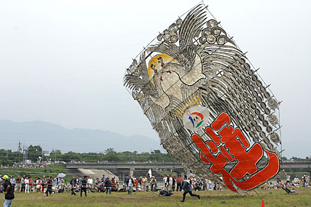
- Yōkaichi Kite Festival
 Kondo-cho, Gokasho
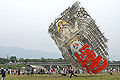 Yōkaichi Giant Kite Festival held in May
 Aga-jinja Shrine or Tarobogu Shrine
 Eigen-ji Temple


Sister cities and cultural exchange cities
Higashiōmi maintains the following sister city relationships.[6]
 Changde, Hunan, China (since August 15, 1994)
 Jangam-myeon, Chungcheongnam-do, South Korea (since November 2, 1992)
 Marquette, Michigan, USA (since August 13, 1979; renewed 2005)
 Rättvik, Dalarna County, Sweden (since November 1, 1994)
 Taber, Alberta, Canada (since March 27, 1981)
- Tongyeong, Gyeongsangnam-do, South Korea (since May 26, 2001)
Noted people from Higashiōmi
- Masayoshi Takemura, politician
- Tadayoshi Ichida, politician
- Mitsunori Okamoto, politician
References
- "Higashiōmi city official statistics" (in Japanese). Japan.
- Higashiōmi climate data
- "東近江 年・月ごとの平年値". Japan Meteorological Agency. Retrieved October 18, 2012.
- "東近江 観測史上1~10位の値". Japan Meteorological Agency. Retrieved January 16, 2014.
- Higashiōmi population statistics
- Sister Cities and Cultural Exchange City of Higashiomi Archived 2008-05-17 at the Wayback Machine. Higashiomi City Homepage. Retrieved on July 10, 2008.
External links
![]() Media related to Higashiōmi, Shiga at Wikimedia Commons
Media related to Higashiōmi, Shiga at Wikimedia Commons
- Higashiōmi City official website (in Japanese)
- Tourist Association website (in Japanese)
- Giant Kite Festival in HigashiomiNHK(video)
Ōtsu (capital) | ||
| Core city | ||
| Cities | ||
| Districts | ||
List of mergers in Shiga Prefecture
| ||
На других языках
[de] Higashiōmi
Higashiōmi (japanisch 東近江市 .mw-parser-output .Latn{font-family:"Akzidenz Grotesk","Arial","Avant Garde Gothic","Calibri","Futura","Geneva","Gill Sans","Helvetica","Lucida Grande","Lucida Sans Unicode","Lucida Grande","Stone Sans","Tahoma","Trebuchet","Univers","Verdana"}-shi, deutsch ‚Ost-Ōmi‘) ist eine Stadt in der Präfektur Shiga in Japan.- [en] Higashiōmi
[ru] Хигасиоми
Хигасиоми (яп. 東近江市 Хигасио:ми-си) — город в Японии, находящийся в префектуре Сига. Площадь города составляет 388,58 км²[1], население — 113 978 человек (1 июля 2014)[2], плотность населения — 293,32 чел./км².Другой контент может иметь иную лицензию. Перед использованием материалов сайта WikiSort.org внимательно изучите правила лицензирования конкретных элементов наполнения сайта.
WikiSort.org - проект по пересортировке и дополнению контента Википедии