world.wikisort.org - India
Rahata taluka, is a taluka in Shrirampur subdivision of Ahmednagar district in Maharashtra State of India.[1]
Rahata taluka | |
|---|---|
Tehsil | |
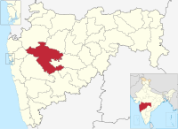
 Location of Rahata in Ahmednagar district in Maharashtra | |
| Country | |
| State | Maharashtra |
| District | Ahmednagar district |
| Headquarters | Shrirampur |
| Area | |
| • Total | 759.19 km2 (293.12 sq mi) |
| Population (2001) | |
| • Total | 288,003 |
| • Density | 380/km2 (980/sq mi) |
| Demographics | |
| • Sex ratio | 68.16 |
Area
The table below shows area of the taluka by land type.[2]
| Type of Land | Area (km2) | % of Total Area |
|---|---|---|
| Agriculture | 689.39 | 90.81 |
| Forest | 16.13 | 2.12 |
| Other | 53.67 | 7.07 |
| Total | 759.19 | 100 |
Villages
There are around 60 villages in Rahata taluka. For list of villages see Villages in Rahata taluka.
Population
The table below shows population of the taluka by sex. The data is as per 2001 census.[3]
| Population | % of Total Population | Number of Literate | Literacy (% of Population) | |
|---|---|---|---|---|
| Male | 148642 | 51.61 | 112294 | 75.55 |
| Female | 139361 | 48.39 | 84002 | 60.28 |
| Total | 288003 | 100 | 196296 | 68.16 |
Rain Fall
The Table below details of rainfall from year 1981 to 2004.[4]
| Year | Rainfall (mm) |
|---|---|
| 2000 | 525 |
| 2001 | 413 |
| 2002 | 385 |
| 2003 | 249 |
| 2004 | 491 |
See also
- Talukas in Ahmednagar district
- Villages in Rahata taluka
References
Текст в блоке "Читать" взят с сайта "Википедия" и доступен по лицензии Creative Commons Attribution-ShareAlike; в отдельных случаях могут действовать дополнительные условия.
Другой контент может иметь иную лицензию. Перед использованием материалов сайта WikiSort.org внимательно изучите правила лицензирования конкретных элементов наполнения сайта.
Другой контент может иметь иную лицензию. Перед использованием материалов сайта WikiSort.org внимательно изучите правила лицензирования конкретных элементов наполнения сайта.
2019-2025
WikiSort.org - проект по пересортировке и дополнению контента Википедии
WikiSort.org - проект по пересортировке и дополнению контента Википедии
