world.wikisort.org - India
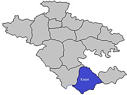
Karjat taluka, is a taluka in Karjat subdivision of Ahmednagar district in Maharashtra State of India.[1][2]
Area
The table below shows area of the taluka by land type.[1]
| Type of Land | Area (km2) | % of Total Area |
|---|---|---|
| Agriculture | 1147.52 | 76.32 |
| Forest | 130.68 | 8.69 |
| Other | 225.41 | 14.99 |
| Total | 1503.61 | 100 |
Villages
There are around 118 villages in Karjat taluka. For list of villages see Villages in Karjat taluka.[1]
Population
The table below shows population of talukas by Gender as per 2001 census.[1]
| Population | % of Total Population | Number of Literate | Literacy (% of Population) | |
|---|---|---|---|---|
| Male | 106347 | 51.73 | 109470 | 102.94 |
| Female | 99238 | 48.27 | 80757 | 81.38 |
| Total | 205585 | 100 | 190227 | 92.53 |
Rainfall
The Table below shows the details of average rainfall from June–October for the period 1981 to 2011.[3]
| Year | Rainfall (mm) | Year | Rainfall (mm) | Year | Rainfall (mm) | Year | Rainfall (mm) |
| 1981 | 542 | 1991 | 391 | 2001 | 495 | 2011 | 413 |
| 1982 | 552 | 1992 | 352 | 2002 | 436 | 2012 | |
| 1983 | 779 | 1993 | 651 | 2003 | 281 | 2013 | |
| 1984 | 532 | 1994 | 493 | 2004 | 565 | 2014 | |
| 1985 | 456 | 1995 | 498 | 2005 | 606 | 2015 | |
| 1986 | 637 | 1996 | 514 | 2006 | 746 | 2016 | |
| 1987 | 432 | 1997 | 328 | 2007 | 401 | 2017 | |
| 1988 | 689 | 1998 | 920 | 2008 | 763 | 2018 | |
| 1989 | 864 | 1999 | 405 | 2009 | 710 | 2019 | |
| 1990 | 597 | 2000 | 400 | 2010 | 729 | 2020 | |
See also
- Talukas in Ahmednagar district
- Villages in Karjat taluka
References
- "New Page 2". Archived from the original on 29 September 2011. Retrieved 21 April 2015.
- "Maps, Weather, and Airports for Karjat, India". Retrieved 21 April 2015.
- "RainFall Information of district Ahmednagar". Archived from the original on 8 December 2015. Retrieved 21 April 2015.
Текст в блоке "Читать" взят с сайта "Википедия" и доступен по лицензии Creative Commons Attribution-ShareAlike; в отдельных случаях могут действовать дополнительные условия.
Другой контент может иметь иную лицензию. Перед использованием материалов сайта WikiSort.org внимательно изучите правила лицензирования конкретных элементов наполнения сайта.
Другой контент может иметь иную лицензию. Перед использованием материалов сайта WikiSort.org внимательно изучите правила лицензирования конкретных элементов наполнения сайта.
2019-2025
WikiSort.org - проект по пересортировке и дополнению контента Википедии
WikiSort.org - проект по пересортировке и дополнению контента Википедии
