world.wikisort.org - India
Patiala district is one of the twenty three districts in the state of Punjab in north-west India.
This article needs additional citations for verification. (December 2009) |
Patiala district | |
|---|---|
District of Punjab | |
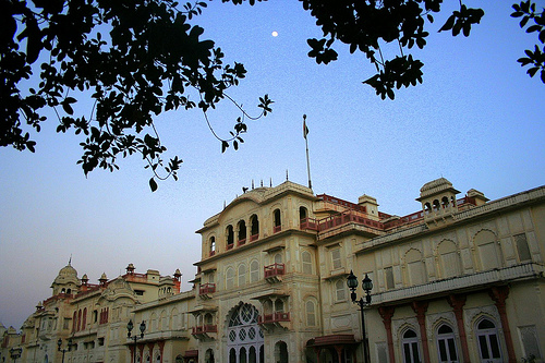 Moti Bagh Palace, Patiala, now houses the National Institute of Sport | |
 Location in Punjab | |
 Patiala district | |
| Coordinates: 39.41°N 116.38°E | |
| Country | |
| State | Punjab |
| Founded by | Baba Ala Singh |
| Headquarters | Patiala |
| Government | |
| • Deputy Commissioner | Kumar Amit, IAS |
| • Senior Superintendent of Police | Sh. Mandeep Singh Sidhu, IPS |
| Area | |
| • Total | 3,218 km2 (1,242 sq mi) |
| Elevation | 257 m (843 ft) |
| Population | |
| • Total | 1,895,686 |
| • Density | 590/km2 (1,500/sq mi) |
| Languages | |
| • Official | Punjabi |
| Time zone | UTC+5:30 (IST) |
| Telephone code | Patiala: 91-(0)175, Rajpura: 91-(0)1762, Samana: 91-(0)1764, Nabha: 91-(0)1765 & Amloh: 91-(0)1768 |
| Literacy | 75.28% |
| Vidhan Sabha constituency | 9 |
| Highways | NH 1, NH 64, NH 71 |
| Website | patiala |
Patiala district lies between 38 47’ and 39 41’ north latitude, 115 58’ and 116 54' east longitude, in the southeast part of the state. It is surrounded by Fatehgarh Sahib, Rupnagar and Mohali to the north, Fatehgarh Sahib and Sangrur districts to the west, Ambala, Panchkula, Haryana to the northeast and Kurukshetra districts of neighboring Haryana state to the east, and Kaithal district of Haryana to the southwest.
Baba Ala Singh (1691–1765), a Sikh chieftain from the village Rampura Phul in Bathinda District of Punjab, with his army of young brave men migrated to Barnala where Baba Ala Singh in 1763 set up his new state. Later Baba Ala Singh moved to a small village of Lehal where he built a new city on the village, naming it as Patiala. He laid the foundations of a steady and stable state known as the Phulkian Dynasty south of Sirhind. In and around Patiala District he founded many villages within his territory, and reconstructed many historical Gurdwaras relating to Sikh religion.
It was since Baba Ala Singh's time that Patiala District came into being as before the area was under the Sirhind Government. Baba Ala Singh made Sirhind, Tohana, Mansa, Bathinda, Sangrur and Barnala, Fatehabad District part of Patiala State.
In 1809, Patiala State came under British protection during the reign of Maharaja Sahib Singh (1773–1813) of Phulkian Dynasty, as he feared that Maharaja Ranjit Singh of Lahore would cross the Sutlej river and take the district and state so the Patiala rulers got the British to protect them from further invasion from 1809 to 1947 Patiala remained under British Protection. In 1948 Patiala Princely State was abolished by the Indian government.
Patiala District was further divided into Fatehgarh Sahib District on 13 April 1992.
Patiala having a population of 1,895,686 is the 4th most populated district of Punjab after Ludhiana, Amritsar, and Jalandhar as per the 2011 census.[citation needed]
Geography
This district contains many small hill ranges that are part of the Shivalik Hills.
Divisions
The district is divided into three sub-divisions: Patiala, Rajpura and Nabha, which are further divided into six tehsils: Patiala, Rajpura, Nabha, Samana, Pattran. Dudansadha It also comprises eight blocks, Patiala, Rajpura, Nabha and Samana.

There are nine Punjab Vidhan Sabha constituencies located in this district: Patiala Urban, Patiala Rural, Rajpura, Nabha, Samana, Ghanaur, Shutrana, Sanaur, and Patran.[1] All of these are part of Patiala Lok Sabha constituency.[2]
Industry
Patiala is fast emerging as an important industrial growth center on the industrial map of the state. Besides traditional goods, high quality and sophisticated items are now produced including small cutting tools, power cables, Vanaspati ghee, bicycles, and agriculture implements including harvester combines and threshers, milk products, and pesticides. The industrial units are scattered all over the district mainly at Rajpura, Patiala, Samana, and Nabha. There are large and medium industrial units located at Rajpura producing Vanaspati ghee, power cables, bicycles, and bicycle components and at Dera Bassi producing spun-yarn and alcohol. Among the small scale industry in the district are those producing agriculture implements, rice shellers, cutting tools, electrical goods, and bakeries. There are industrial focal points at Patiala, Rajpura, Nabha, and Dera Bassi and two industrial estates at Rajpura, Patiala.
Demographics
According to the 2011 census, Patiala district has a population of 1,895,686,[4] roughly equal to the nation of Slovenia[5] or the US state of Mississippi.[6] This gives it a ranking of 248th in India (out of a total of 640).[4] The district has a population density of 596 inhabitants per square kilometre (1,540/sq mi).[4] Its population growth rate over the decade 2001-2011 was 19.4%.[4] Patiala has a sex ratio of 888 females for every 1000 males,[4] and a literacy rate of 76.3%. Scheduled Castes made up 24.55% of the population.[4]
| Year | Pop. | ±% p.a. |
|---|---|---|
| 1951 | 482,517 | — |
| 1961 | 673,730 | +3.39% |
| 1971 | 855,029 | +2.41% |
| 1981 | 1,112,368 | +2.67% |
| 1991 | 1,343,517 | +1.91% |
| 2001 | 1,584,780 | +1.67% |
| 2011 | 1,895,686 | +1.81% |
| source:[7] | ||
Languages of Patiala district (2011)[8]
At the time of the 2011 census, 89.61% of the population spoke Punjabi, 7.79% Hindi and 1.24% Bahawalpuri as their first language.[8]
Topography
Most of the area is plains in the form of agricultural land. The river Ghaghar remains dry during most part of the year. However, during the rainy season, it often causes flooding in the adjoining villages, which results in damage to the crops, livestock, and human lives. Other subsidiary rivers are Tangri Nadi, Patiala-Wali-Nadi, Sirhind Choe, and the Jhambowali Choe.
Apart from the natural water lines, the Bhakra Main Line canal, the Nawana Branch, and the Ghaghar Link are the most important. These canals are the backbone of the irrigation system of the district.
Politics
| No. | Constituency | Name of MLA | Party | Bench | |
|---|---|---|---|---|---|
| 109 | Nabha (SC) | Gurdev Singh Dev Maan | Aam Aadmi Party | Government | |
| 110 | Patiala Rural | Balbir Singh | Aam Aadmi Party | Government | |
| 111 | Rajpura | Neena Mittal | Aam Aadmi Party | Government | |
| 113 | Ghanaur | Gurlal Ghanaur | Aam Aadmi Party | Government | |
| 114 | Sanour | Harmit Singh Pathanmajra | Aam Aadmi Party | Government | |
| 115. | Patiala | Ajit Pal Singh Kohli | Aam Aadmi Party | Government | |
| 116 | Samana | Chetan Singh Jaura Majra | Aam Aadmi Party | Government | |
| 117 | Shutrana (SC) | Kulwant Singh Bazigar | Aam Aadmi Party | Government | |
References
- "District Wise Assembly Constituencies" (PDF). Chief Electoral Officer, Haryana website. Archived from the original (PDF) on 21 July 2011. Retrieved 28 March 2011.
- "Delimitation of Parliamentary and Assembly Constituencies Order, 2008" (PDF). The Election Commission of India. p. 157.
- "Patiala District Religion Data - Census 2011". www.census2011.co.in.
- "District Census Hand Book – Patiala" (PDF). Census of India. Registrar General and Census Commissioner of India.
- US Directorate of Intelligence. "Country Comparison:Population". Archived from the original on 13 June 2007. Retrieved 1 October 2011.
Lesotho 2,124,886
- "2010 Resident Population Data". U. S. Census Bureau. Archived from the original on 19 October 2013. Retrieved 30 September 2011.
Mississippi 1,852,994
- Decadal Variation In Population Since 1901
- "Table C-16 Population by Mother Tongue: Punjab". censusindia.gov.in. Registrar General and Census Commissioner of India.
External links
- . Encyclopædia Britannica (11th ed.). 1911.
Places adjacent to Patiala district | ||||||||||||||||
|---|---|---|---|---|---|---|---|---|---|---|---|---|---|---|---|---|
| ||||||||||||||||
State of Punjab, India | ||
|---|---|---|
Capital: Chandigarh | ||
| Topics |
|  |
| Administration |
| |
| Culture |
| |
| Divisions |
| |
| Districts |
| |
| Major Cities | ||
Authority control | |
|---|---|
| General |
|
| National libraries | |
На других языках
[de] Patiala (Distrikt)
Der Distrikt Patiala (Panjabi ਪਟਿਆਲਾ ਜ਼ਿਲ੍ਹਾ) ist ein Verwaltungsdistrikt im indischen Bundesstaat Punjab. Die Hauptstadt ist Patiala.- [en] Patiala district
[ru] Патиала (округ)
Патиала или Патия́ла (в.-пандж. ਪਟਿਆਲਾ ਜ਼ਿਲਾ; англ. Patiala) — округ в индийском штате Пенджаб. Образован в 2002 году из части территории округа Туенсанг. Административный центр — город Патиала. Площадь округа — 3627 км². По данным всеиндийской переписи 2001 года население округа составляло 1 844 934 человека. Уровень грамотности взрослого населения составлял 69,8 %, что выше среднеиндийского уровня (59,5 %). Доля городского населения составляла 34,9 %.Другой контент может иметь иную лицензию. Перед использованием материалов сайта WikiSort.org внимательно изучите правила лицензирования конкретных элементов наполнения сайта.
WikiSort.org - проект по пересортировке и дополнению контента Википедии