world.wikisort.org - India
Giridih district is one of the twenty-four districts of Jharkhand state, India, and Giridih is the administrative headquarters of this district. As of 2011 it is the third most populous district of Jharkhand (out of 24), after Ranchi and Dhanbad.[1]
Giridih district | |
|---|---|
District of Jharkhand | |
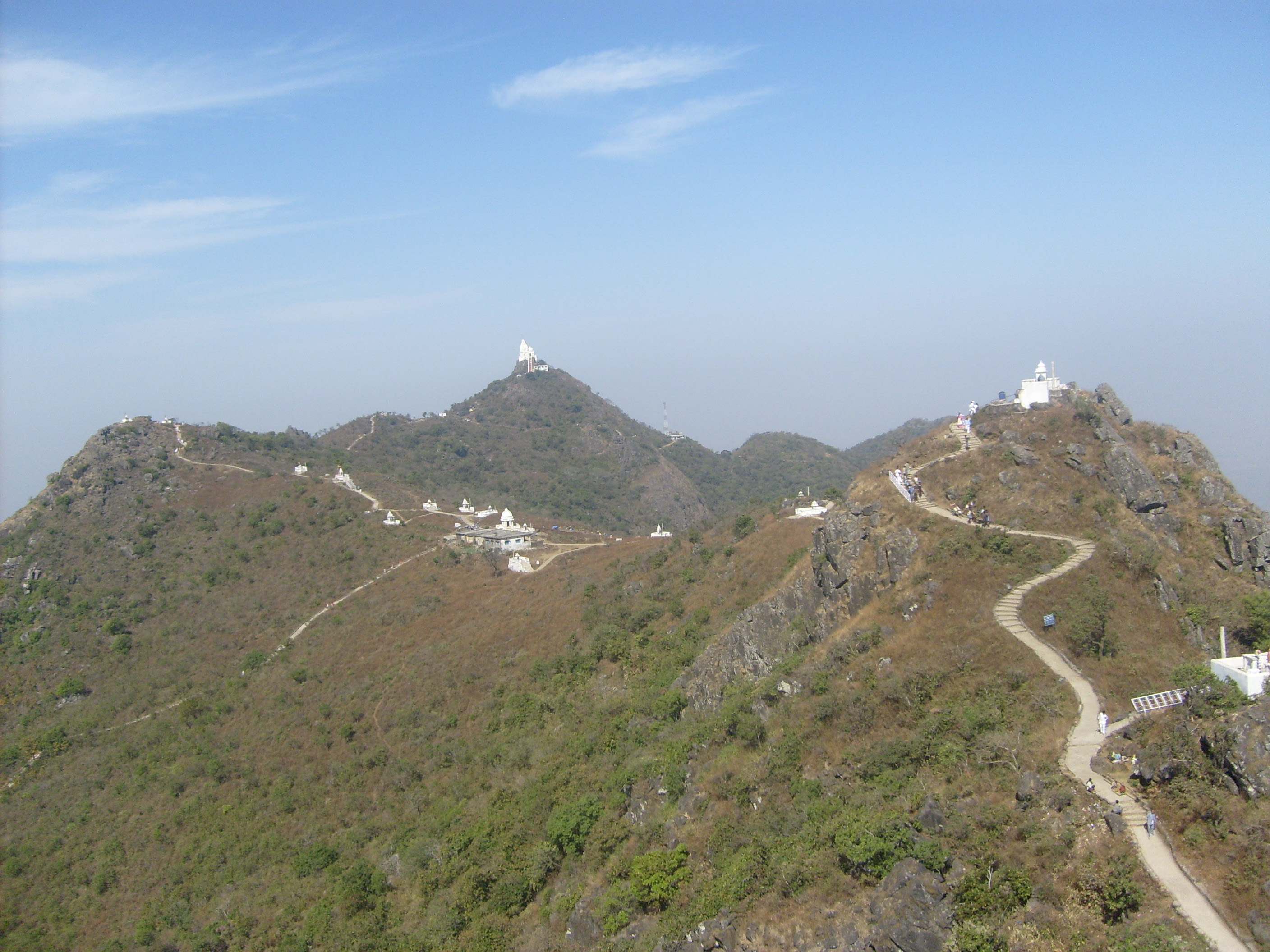 Hills of Shikarji Parasnath Temple | |
 Location of Giridih district in Jharkhand | |
| Country | |
| State | |
| Division | North Chotanagpur |
| Headquarters | Giridih |
| Government | |
| • District Commissioner | Mr. Naman Priyesh Lakra |
| • Lok Sabha constituencies | 1. Kodarma, 2. Giridih |
| • Vidhan Sabha constituencies | 6 |
| Area | |
| • Total | 4,962 km2 (1,916 sq mi) |
| Population (2011) | |
| • Total | 2,445,474[1] |
| • Urban | 06.41 |
| Demographics | |
| • Literacy | 65.12 per cent[1][2] |
| • Sex ratio | 940 |
| Time zone | UTC+05:30 (IST) |
| Website | giridih |
History
Giridh district was a part of Kharagdiha estate till late 18th century. During the British Raj Giridih became a part of Jungle Terry. After Kol Uprising in 1831, the parganas of Ramgarh, Kharagdiha, Kendi and Kunda became parts of the South-West Frontier Agency and were formed into a division named Hazaribag as the administrative headquarters. The Kharagdiha Rajas were settled as Rajas of Raj Dhanwar in 1809, and the Kharagdiha gadis were separately settled as zamindari estates. Some of the notable Kharagdiha Zamindari estates were Koderma, Gadi Palganj, Ledo Gadi, Gande Gadi, Ghoranji Gadi and Gadi Sirsia.[3] Giridih district was created on 6 December 1972 by carving some parts of Hazaribagh district. In 1999 part of it became Bokaro district.[4]
It is currently a part of the Red Corridor.[5] The 15,000-capacity football and cricket stadium named Giridih Stadium is the largest sports venue by capacity in the region. It is located in the town of Mahthadih.
Geography
The district, covering an area of around 4854 km², is bounded on the north by Jamui district and Nawada district of Bihar state, on the east by the districts of Deoghar and Jamtara, on the south by Dhanbad and Bokaro, and on the west by Hazaribagh and Koderma districts.
Giridih has an average elevation of 289 metres (948 feet). Śrī Sammeta Shikharji also known as the Parasnath Hills, located in Giridih is the highest mountain peak in Jharkhand. It is a conical granite peak located 4,477 feet (1,382 metres) above the sea level.[6][7]
Gawan and Tisari blocks of the district have several mica mines, and coal is found abundantly at several places throughout the district.[7]
Parasnath Hills are located in the district. There are two major rivers, namely, the Barakar River and the Sakri River. Barakar River passes through Birni and Pirtand blocks. Sakari river drains the areas of Deori and Gawan blocks. There are several smaller rivers, including Usri, with a major tourist attraction - Usri Falls.
Administration
Blocks
Giridih district comprises the following 13 blocks:
Subdivisions
Following are the four subdivision of the district:[8]
- Giridih subdivision
- Bagodar-Sariya subdivision
- Khorimahua subdivision
- Dumri subdivision
Economy
In 2006 the Indian government named Giridh one of the country's 250 most backward districts (out of a total of 640).[9] It is one of the 21 districts in Jharkhand currently receiving funds from the Backward Regions Grant Fund Programme (BRGF).[9]
The DDP of Giridih District is ₹1,97,771(2003-04) and Income Per Capita is ₹9921(2003-04).
Divisions
There are six Vidhan Sabha (legislative assembly) constituencies in this district. Dhanwar, Bagodar, Jamua and Gandey assembly constituencies are part of Kodarma constituency. Giridih and Dumri assembly constituencies are part of Giridih constituency.[10]
Demographics
| Year | Pop. | ±% p.a. |
|---|---|---|
| 1901 | 375,866 | — |
| 1911 | 411,172 | +0.90% |
| 1921 | 407,450 | −0.09% |
| 1931 | 484,161 | +1.74% |
| 1941 | 558,821 | +1.44% |
| 1951 | 618,129 | +1.01% |
| 1961 | 747,946 | +1.92% |
| 1971 | 937,092 | +2.28% |
| 1981 | 1,161,066 | +2.17% |
| 1991 | 1,496,878 | +2.57% |
| 2001 | 1,905,343 | +2.44% |
| 2011 | 2,445,474 | +2.53% |
| source:[11] | ||
According to the 2011 census Giridih district has a population of 2,445,474[1] roughly equal to the nation of Kuwait[12] or the US state of New Mexico.[13] This gives it a ranking of 182nd in India (out of a total of 640).[1] The district has a population density of 497 inhabitants per square kilometre (1,290/sq mi) . Its population growth rate over the decade 2001-2011 was 28.33%. Giridih has a sex ratio of 943 females for every 1000 males, and a literacy rate of 65.12%.[1]
Schedule Caste (SC) constitutes 13.3% while Schedule Tribe (ST) were 9.7% of total population.
78.1% of the population is Hindu, 20.3% is Muslim, 2.42% are Others and 0.6% Christian.[1]
At the time of the 2011 Census of India, 68.71% of the population in the district spoke Khortha, 13.55% Hindi, 8.99% Santali and 7.47% Urdu as their first language.[14]
Khortha, a blend of Magahi and Bengali, is the main language spoken in Giridih district. The tribal people speak Santhali.
Flora and fauna
The district has rich forest resources and have several jungles of sal trees and bamboos, and a variety of other indigenous trees. Among other common trees are bamboo, semal, Mahua, palash, kusum, kend, Asian pear and bhelwa.[7] Parasnath hills have a number of plants having medicinal use. Leopards, bears, jackals, wild pigs, and hares are the wild animals found in certain parts of the district which have thick forests.
Politics
| No. | Constituency | Name | Party | Alliance | Remarks | |||||||||||||||||||||||||||||||||||||||||||||||||
|---|---|---|---|---|---|---|---|---|---|---|---|---|---|---|---|---|---|---|---|---|---|---|---|---|---|---|---|---|---|---|---|---|---|---|---|---|---|---|---|---|---|---|---|---|---|---|---|---|---|---|---|---|---|---|
| 28 | Dhanwar | Babulal Marandi | Bharatiya Janata Party | NDA | JVM (P) merged into BJP[15] | |||||||||||||||||||||||||||||||||||||||||||||||||
| 29 | Bagodar | Vinod Kumar Singh | Communist Party of India (Marxist–Leninist) Liberation | UPA | ||||||||||||||||||||||||||||||||||||||||||||||||||
| 30 | Jamua | Kedar Hazra | Bharatiya Janata Party | NDA | ||||||||||||||||||||||||||||||||||||||||||||||||||
| 31 | Gandey | Dr. Sarfraz Ahmad | Jharkhand Mukti Morcha | UPA | ||||||||||||||||||||||||||||||||||||||||||||||||||
| 32 | Giridih | Sudivya Kumar | Jharkhand Mukti Morcha | UPA | ||||||||||||||||||||||||||||||||||||||||||||||||||
| 33 | Dumri | Jagarnath Mahto | Jharkhand Mukti Morcha | UPA | Cabinet Minister
|} Tourism
References
External links
| |||||||||||||||||||||||||||||||||||||||||||||||||
На других языках
[de] Giridih (Distrikt)
Giridih ist ein Distrikt im indischen Bundesstaat Jharkhand.- [en] Giridih district
[ru] Гиридих (округ)
Гиридих (хинди गिरिडीह जिला; англ. Giridih) — округ в индийском штате Джаркханд. Образован в 1972 году из части территории округа Хазарибагх. Административный центр — город Гиридих. Площадь округа — 4975 км². По данным всеиндийской переписи 2001 года население округа составляло 1 904 430 человек. Уровень грамотности взрослого населения составлял 45,5 %, что ниже среднеиндийского уровня (59,5 %). Доля городского населения составляла 6,4 %. В 1991 году из частей территорий округов Дханбад и Гиридих был образован округ Бокаро.Другой контент может иметь иную лицензию. Перед использованием материалов сайта WikiSort.org внимательно изучите правила лицензирования конкретных элементов наполнения сайта.
WikiSort.org - проект по пересортировке и дополнению контента Википедии