world.wikisort.org - Germany
Höxter (German pronunciation: [ˈhœkstɐ]) is a Kreis (district) in the east of North Rhine-Westphalia, Germany. Neighboring districts are Holzminden, Northeim, Kassel, Waldeck-Frankenberg, Hochsauerland, Paderborn, and Lippe.
Höxter | |
|---|---|
District | |
 Flag  Coat of arms | |
 | |
| Country | Germany |
| State | North Rhine-Westphalia |
| Adm. region | Detmold |
| Capital | Höxter |
| Area | |
| • Total | 1,201.42 km2 (463.87 sq mi) |
| Population (31 December 2020)[1] | |
| • Total | 139,729 |
| • Density | 120/km2 (300/sq mi) |
| Time zone | UTC+01:00 (CET) |
| • Summer (DST) | UTC+02:00 (CEST) |
| Vehicle registration | HX, WAR |
| Website | http://www.kreis-hoexter.de |
History
The area of the current Höxter district was part of the Bishopric of Paderborn until it was included into Prussia in 1802. In 1816 the new Prussian government created three districts in the area, Höxter, Brakel and Warburg. In 1832 Höxter and Brakel were merged.
The present district was created in 1975 when the former districts Warburg and Höxter were merged. At the same time the towns and municipalities in the district were merged to form the today's ten towns.
Geography
Geographically the district covers the hills east of the Teutoburg Forest, especially the Eggegebirge, and parts of the Weserbergland. The highest elevation is the Köterberg (Elevation 496 m). The main river is the Weser in the east of the district.
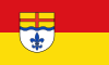
Coat of arms
The lily in the bottom comes from the old coat of arms of the Warburg district, and is also found in the coat of arms of the city Warburg. The blue wave line stands for the river Weser, and the cross in the top derives from the coat of arms of the Bishopric of Paderborn.
Towns and municipalities

|
|
References
- "Bevölkerung der Gemeinden Nordrhein-Westfalens am 31. Dezember 2020" (in German). Landesbetrieb Information und Technik NRW. Retrieved 21 June 2021.
External links
![]() Media related to Kreis Höxter at Wikimedia Commons
Media related to Kreis Höxter at Wikimedia Commons
- Official website (in German)
| Urban districts |  | |
|---|---|---|
| Rural districts |
| |
Districts of German states (Full list)
| ||
Authority control | |
|---|---|
| General | |
| National libraries | |
На других языках
[de] Kreis Höxter
Der Kreis Höxter ist ein Kreis im Regierungsbezirk Detmold (Ostwestfalen-Lippe) im äußersten Osten Nordrhein-Westfalens und liegt mit seinen Grenzen am Dreiländereck zu Niedersachsen und Hessen.- [en] Höxter (district)
[ru] Хёкстер (район)
Хёкстер (нем. Höxter) — район в Германии. Центр района — город Хёкстер. Район входит в землю Северный Рейн-Вестфалия. Подчинён административному округу Детмольд. Занимает площадь 1200 км². Население — 148,0 тыс. чел. (2010). Плотность населения — 123 человека/км². Официальный код района — 05 7 62.Другой контент может иметь иную лицензию. Перед использованием материалов сайта WikiSort.org внимательно изучите правила лицензирования конкретных элементов наполнения сайта.
WikiSort.org - проект по пересортировке и дополнению контента Википедии