world.wikisort.org - France
Villetelle (French pronunciation: [viltɛl]; Occitan: Vilatèla) is a commune in the Hérault department in the Occitanie region in southern France.
Villetelle | |
|---|---|
Commune | |
 Square. In the background on the left: the town hall, on its right the Saint Géraud church. | |
 Coat of arms | |
Location of Villetelle  | |
 Villetelle  Villetelle | |
| Coordinates: 43°44′05″N 4°08′26″E | |
| Country | France |
| Region | Occitania |
| Department | Hérault |
| Arrondissement | Montpellier |
| Canton | Lunel |
| Government | |
| • Mayor (2020–2026) | Jean-Pierre Navas[1] |
| Area 1 | 5.31 km2 (2.05 sq mi) |
| Population | 1,467 |
| • Density | 280/km2 (720/sq mi) |
| Time zone | UTC+01:00 (CET) |
| • Summer (DST) | UTC+02:00 (CEST) |
| INSEE/Postal code | 34340 /34400 |
| Elevation | 10–67 m (33–220 ft) (avg. 37 m or 121 ft) |
| 1 French Land Register data, which excludes lakes, ponds, glaciers > 1 km2 (0.386 sq mi or 247 acres) and river estuaries. | |
Geography
The river Vidourle crosses the commune.
History

The Gallo-Roman archaeological site of Ambrussum is located there.
Education
This section is empty. You can help by adding to it. (June 2019) |
Administration
| Election | Mayor | Party | Occupation | |
|---|---|---|---|---|
| 2001 | Jean-Pierre Navas | DVG | Retiree | |
Population
|
|
Pictures
 Saint Géraud church
 alley behind the church
 The porch from the church
 The porch square
 The old forge
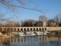 Vidourle river between Aubais and Villetelle


See also
- Pont Ambroix
- Communes of the Hérault department
References
- "Répertoire national des élus: les maires". data.gouv.fr, Plateforme ouverte des données publiques françaises (in French). 2 December 2020.
- "Populations légales 2019". The National Institute of Statistics and Economic Studies. 29 December 2021.
External links
Wikimedia Commons has media related to Villetelle.
- Official Web site
- Tourist office Web site
- Ambrussum Web site
This Hérault geographical article is a stub. You can help Wikipedia by expanding it. |
На других языках
[de] Villetelle
Villetelle (okzitanisch: Vilatèla) ist ein Ort und eine Gemeinde mit 1.467 Einwohnern (Stand 1. Januar 2019) im Département Hérault in der Region Okzitanien in Südfrankreich.- [en] Villetelle
[es] Villetelle
Villetelle es una localidad y comuna francesa situada en el departamento de Hérault, en la región de Occitania.Текст в блоке "Читать" взят с сайта "Википедия" и доступен по лицензии Creative Commons Attribution-ShareAlike; в отдельных случаях могут действовать дополнительные условия.
Другой контент может иметь иную лицензию. Перед использованием материалов сайта WikiSort.org внимательно изучите правила лицензирования конкретных элементов наполнения сайта.
Другой контент может иметь иную лицензию. Перед использованием материалов сайта WikiSort.org внимательно изучите правила лицензирования конкретных элементов наполнения сайта.
2019-2026
WikiSort.org - проект по пересортировке и дополнению контента Википедии
WikiSort.org - проект по пересортировке и дополнению контента Википедии