world.wikisort.org - France
The arrondissement of Montpellier is an arrondissement of France. It is part of the Hérault département. Its INSEE code is 343 and its capital city, and prefecture of the department, is Montpellier. It has 67 communes.[2] Its population is 683,935 (2016), and its area is 1,004.8 km2 (388.0 sq mi).[3]
Montpellier | |
|---|---|
Arrondissement | |
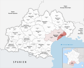 Location within the region Occitanie | |
| Country | France |
| Region | Occitania |
| Department | Hérault |
| No. of communes | 67 |
| Prefecture | Montpellier |
| Area | 1,004.8 km2 (388.0 sq mi) |
| Population | 713,622 |
| • Density | 710/km2 (1,800/sq mi) |
| INSEE code | 343 |
The main cities in the arrondissement, with more than 20,000 inhabitants in 2019, are Montpellier (295,542 inhabitants), Sète (43,858 inhabitants), Lunel (26,385 inhabitants), Frontignan (23,028 inhabitants) and Castelnau-le-Lez (22,534 inhabitants).[4]
Geography
The arrondissement covers the northeastern part of the department and is bordered to the north and northeast by the Gard department, to the east and south by the Gulf of Lion (Mediterranean Sea), to the southwest by the arrondissement of Béziers and to the west by the arrondissement of Lodève.
Composition
The communes of the arrondissement of Montpellier are (with their INSEE codes):[2]
- Baillargues (34022)
- Balaruc-le-Vieux (34024)
- Balaruc-les-Bains (34023)
- Beaulieu (34027)
- Boisseron (34033)
- Bouzigues (34039)
- Campagne (34048)
- Candillargues (34050)
- Castelnau-le-Lez (34057)
- Castries (34058)
- Clapiers (34077)
- Cournonsec (34087)
- Cournonterral (34088)
- Le Crès (34090)
- Entre-Vignes (34246)
- Fabrègues (34095)
- Frontignan (34108)
- Galargues (34110)
- Garrigues (34112)
- Gigean (34113)
- Grabels (34116)
- La Grande-Motte (34344)
- Jacou (34120)
- Juvignac (34123)
- Lansargues (34127)
- Lattes (34129)
- Lavérune (34134)
- Loupian (34143)
- Lunel (34145)
- Lunel-Viel (34146)
- Marseillan (34150)
- Marsillargues (34151)
- Mauguio (34154)
- Mireval (34159)
- Montaud (34164)
- Montbazin (34165)
- Montferrier-sur-Lez (34169)
- Montpellier (34172)
- Mudaison (34176)
- Murviel-lès-Montpellier (34179)
- Mèze (34157)
- Palavas-les-Flots (34192)
- Pignan (34202)
- Poussan (34213)
- Prades-le-Lez (34217)
- Pérols (34198)
- Restinclières (34227)
- Saint-Aunès (34240)
- Saint-Brès (34244)
- Saint-Drézéry (34249)
- Saint-Geniès-des-Mourgues (34256)
- Saint-Georges-d'Orques (34259)
- Saint-Jean-de-Védas (34270)
- Saint-Just (34272)
- Saint-Nazaire-de-Pézan (34280)
- Saint-Sériès (34288)
- Saturargues (34294)
- Saussan (34295)
- Saussines (34296)
- Sussargues (34307)
- Sète (34301)
- Valergues (34321)
- Vendargues (34327)
- Vic-la-Gardiole (34333)
- Villeneuve-lès-Maguelone (34337)
- Villetelle (34340)
- Villeveyrac (34341)
History
The arrondissement of Montpellier was created in 1800.[5] In 2009 it lost the three cantons of Aniane, Ganges and Saint-Martin-de-Londres to the arrondissement of Lodève.[6] At the January 2017 reorganisation of the arrondissements of Hérault, it gained one commune from the arrondissement of Béziers, and it lost 26 communes to the arrondissement of Lodève.[7]
As a result of the reorganisation of the cantons of France which came into effect in 2015, the borders of the cantons are no longer related to the borders of the arrondissements. The cantons of the arrondissement of Montpellier were, as of January 2015:[8]
- Castelnau-le-Lez
- Castries
- Claret
- Frontignan
- Lattes
- Lunel
- Les Matelles
- Mauguio
- Mèze
- Montpellier-1
- Montpellier-2
- Montpellier-3
- Montpellier-4
- Montpellier-5
- Montpellier-6
- Montpellier-7
- Montpellier-8
- Montpellier-9
- Montpellier-10
- Pignan
- Sète-1
- Sète-2
References
- "Téléchargement du fichier d'ensemble des populations légales en 2019". The National Institute of Statistics and Economic Studies. 28 December 2020.
- "Arrondissement de Montpellier (343)". INSEE. Retrieved 2019-09-30.
- "Comparateur de territoire, géographie au 01/01/2019". INSEE. Retrieved 2019-09-30.
- Populations légales 2019: 34 Hérault, INSEE
- Historique de l'Hérault
- "Arrêté préfectoral, 28 July 2009" (PDF). pp. 41–43. Retrieved 2019-10-21.
- "Arrêté préfectoral, 29 December 2016" (PDF). pp. 62–70. Retrieved 2019-10-21.
- Populations légales 2012: 34 Hérault, INSEE
|
Authority control | |
|---|---|
| General |
|
| National libraries | |
На других языках
- [en] Arrondissement of Montpellier
[ru] Монпелье (округ)
Монпелье (фр. Montpellier) — округ (фр. Arrondissement) во Франции, один из округов в регионе Окситания. Департамент округа — Эро. Супрефектура — Монпелье. Население округа на 2016 год составляло 683 935 человек. Плотность населения составляет 496 чел./км². Площадь округа составляет 1004.8 км²[1].Другой контент может иметь иную лицензию. Перед использованием материалов сайта WikiSort.org внимательно изучите правила лицензирования конкретных элементов наполнения сайта.
WikiSort.org - проект по пересортировке и дополнению контента Википедии