world.wikisort.org - France
Saint-Péray (French pronunciation: [sɛ̃ peʁɛ] (![]() listen); Occitan: Sant Pèire d'Ai) is a commune in the Ardèche department in the Auvergne-Rhône-Alpes region in southern France.
listen); Occitan: Sant Pèire d'Ai) is a commune in the Ardèche department in the Auvergne-Rhône-Alpes region in southern France.
This article may be expanded with text translated from the corresponding article in French. (December 2008) Click [show] for important translation instructions.
|
Saint-Péray | |
|---|---|
Commune | |
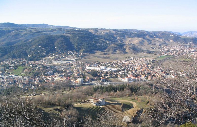 A general view of Saint-Péray | |
 Coat of arms | |
Location of Saint-Péray  | |
 Saint-Péray  Saint-Péray | |
| Coordinates: 44°56′58″N 4°50′45″E | |
| Country | France |
| Region | Auvergne-Rhône-Alpes |
| Department | Ardèche |
| Arrondissement | Tournon-sur-Rhône |
| Canton | Guilherand-Granges |
| Government | |
| • Mayor (2020–2026) | Jacques Dubay |
| Area 1 | 24.05 km2 (9.29 sq mi) |
| Population | 7,580 |
| • Density | 320/km2 (820/sq mi) |
| Time zone | UTC+01:00 (CET) |
| • Summer (DST) | UTC+02:00 (CEST) |
| INSEE/Postal code | 07281 /07130 |
| Elevation | 107–652 m (351–2,139 ft) (avg. 128 m or 420 ft) |
| 1 French Land Register data, which excludes lakes, ponds, glaciers > 1 km2 (0.386 sq mi or 247 acres) and river estuaries. | |
Population
|
| ||||||||||||||||||||||||||||||||||||||||||||||||||||||||||||||||||||||||||||||||||||||||||||||||||||||||||||||||||
| Source: EHESS[2] and INSEE (1968-2017)[3] | |||||||||||||||||||||||||||||||||||||||||||||||||||||||||||||||||||||||||||||||||||||||||||||||||||||||||||||||||||
See also
- Château de Crussol, located on the territory of the commune.
- Communes of the Ardèche department
References
- "Populations légales 2019". The National Institute of Statistics and Economic Studies. 29 December 2021.
- Des villages de Cassini aux communes d'aujourd'hui: Commune data sheet Saint-Péray, EHESS. (in French)
- Population en historique depuis 1968, INSEE
Wikimedia Commons has media related to Saint-Péray.
| Authority control |
|
|---|
This Ardèche geographical article is a stub. You can help Wikipedia by expanding it. |
На других языках
[de] Saint-Péray
Saint-Péray ist eine französische Gemeinde mit 7.580 Einwohnern (Stand 1. Januar 2019) im Département Ardèche, Region Auvergne-Rhône-Alpes. Sie liegt etwa fünf Kilometer westlich von Valence an der Ostflanke des Zentralmassivs. Sie wird von den Ruinen der Burg Crussol überragt. Das auf der orographisch rechten Seite der Rhone gelegene Saint-Péray ist für seine Weißweine bekannt und liegt nur rund fünf Kilometer von Cornas, einer bekannten Rotweingemeinde der Rhône entfernt. Sowohl Cornas wie auch Saint-Péray werden weitgehend von den kalten Winden des Mistral verschont. Das Gemeindegebiet wird vom Fluss Mialan durchquert.- [en] Saint-Péray
[es] Saint-Péray
Saint-Péray es una comuna francesa situada en el departamento de Ardèche, en la región de Auvernia-Ródano-Alpes.[ru] Сен-Пере
Сен-Пере́ (фр. Saint-Péray, окс. Sant Pèire d'Ai) — коммуна во Франции, находится в регионе Рона — Альпы. Департамент коммуны — Ардеш. Входит в состав кантона Сен-Пере. Округ коммуны — Турнон-сюр-Рон.Текст в блоке "Читать" взят с сайта "Википедия" и доступен по лицензии Creative Commons Attribution-ShareAlike; в отдельных случаях могут действовать дополнительные условия.
Другой контент может иметь иную лицензию. Перед использованием материалов сайта WikiSort.org внимательно изучите правила лицензирования конкретных элементов наполнения сайта.
Другой контент может иметь иную лицензию. Перед использованием материалов сайта WikiSort.org внимательно изучите правила лицензирования конкретных элементов наполнения сайта.
2019-2026
WikiSort.org - проект по пересортировке и дополнению контента Википедии
WikiSort.org - проект по пересортировке и дополнению контента Википедии