world.wikisort.org - France
Saint Pierre (French pronunciation: [sɛ̃.pjɛʁ]) is the third-largest commune in the French overseas department and region of Réunion. Located on the southwest side of the island, it is the capital of the French Southern and Antarctic Lands. It developed from a port built from 1854 to 1882, which was used for the trade between Asia and Europe. Today, it features 400 sites for fishing and pleasure boats, while most of the commercial traffic moved north to Le Port.
Saint Pierre | |
|---|---|
Subprefecture and commune | |
 An aerial view of part of Saint-Pierre and its port | |
 Coat of arms | |
| Motto: Fortis fortuna fortior (Latin: 'Courage is stronger than fortune') | |
 | |
Location of Saint Pierre  | |
| Coordinates: 21°20′31″S 55°28′40″E | |
| Country | France |
| Overseas region and department | Réunion |
| Arrondissement | Saint-Pierre |
| Canton | Saint-Pierre-1, 2 and 3 |
| Intercommunality | Villes solidaires |
| Government | |
| • Mayor (2020–2026) | Michel Fontaine[1] (LR) |
| Area 1 | 95.99 km2 (37.06 sq mi) |
| Population | 84,982 |
| • Density | 890/km2 (2,300/sq mi) |
| Time zone | UTC+04:00 |
| INSEE/Postal code | 97416 /97410 |
| Elevation | 0–1,642 m (0–5,387 ft) (avg. 19 m or 62 ft) |
| 1 French Land Register data, which excludes lakes, ponds, glaciers > 1 km2 (0.386 sq mi or 247 acres) and river estuaries. | |
Geography
The town of Saint-Pierre is at the beginning of the only major road N3 across the island. From here, the road leads to Le Tampon, La Plaine des Cafres and Bourg Murat. From that area, there is a relatively easy access to the Piton de la Fournaise and a starting point of many excursions.
Climate
Saint-Pierre has a hot semi-arid climate (Köppen climate classification BSh), while Ligne Paradis and Ravine des Cabris's climate type has tropical savanna climate (Köppen climate classification Aw) in the southeast of the area. The average annual temperature in Saint-Pierre (downtown) is 24.1 °C (75.4 °F). The average annual rainfall is 672.1 mm (26.46 in) with February as the wettest month. The temperatures are highest on average in January, at around 27.3 °C (81.1 °F), and lowest in July, at around 20.9 °C (69.6 °F). The highest temperature ever recorded in Saint-Pierre (downtown) was 35.7 °C (96.3 °F) on 20 February 2007; the coldest temperature ever recorded was 12.6 °C (54.7 °F) on 15 September 2020.
| Climate data for Saint-Pierre (downtown, altitude 61m, 1991–2020 normals, extremes 1997−present) | |||||||||||||
|---|---|---|---|---|---|---|---|---|---|---|---|---|---|
| Month | Jan | Feb | Mar | Apr | May | Jun | Jul | Aug | Sep | Oct | Nov | Dec | Year |
| Record high °C (°F) | 35.6 (96.1) |
35.7 (96.3) |
34.5 (94.1) |
33.2 (91.8) |
32.0 (89.6) |
30.5 (86.9) |
31.5 (88.7) |
29.4 (84.9) |
30.7 (87.3) |
31.7 (89.1) |
32.8 (91.0) |
34.9 (94.8) |
35.7 (96.3) |
| Average high °C (°F) | 31.6 (88.9) |
31.6 (88.9) |
31.1 (88.0) |
29.9 (85.8) |
28.2 (82.8) |
26.5 (79.7) |
25.6 (78.1) |
26.0 (78.8) |
26.8 (80.2) |
28.0 (82.4) |
29.5 (85.1) |
30.9 (87.6) |
28.8 (83.8) |
| Daily mean °C (°F) | 27.1 (80.8) |
27.1 (80.8) |
26.5 (79.7) |
25.3 (77.5) |
23.6 (74.5) |
21.8 (71.2) |
20.9 (69.6) |
21.0 (69.8) |
21.7 (71.1) |
23.0 (73.4) |
24.5 (76.1) |
26.1 (79.0) |
24.1 (75.4) |
| Average low °C (°F) | 22.5 (72.5) |
22.6 (72.7) |
21.9 (71.4) |
20.7 (69.3) |
19.0 (66.2) |
17.1 (62.8) |
16.2 (61.2) |
16.0 (60.8) |
16.6 (61.9) |
18.0 (64.4) |
19.6 (67.3) |
21.3 (70.3) |
19.3 (66.7) |
| Record low °C (°F) | 18.4 (65.1) |
17.6 (63.7) |
17.8 (64.0) |
16.6 (61.9) |
14.7 (58.5) |
13.4 (56.1) |
13.1 (55.6) |
12.9 (55.2) |
12.6 (54.7) |
14.5 (58.1) |
15.7 (60.3) |
17.1 (62.8) |
12.6 (54.7) |
| Average precipitation mm (inches) | 108.7 (4.28) |
116.1 (4.57) |
97.2 (3.83) |
74.8 (2.94) |
47.7 (1.88) |
49.5 (1.95) |
53.4 (2.10) |
25.6 (1.01) |
20.5 (0.81) |
17.3 (0.68) |
30.9 (1.22) |
53.0 (2.09) |
694.7 (27.35) |
| Average precipitation days (≥ 1.0 mm) | 7.1 | 8.3 | 8.0 | 6.7 | 5.5 | 6.2 | 6.1 | 3.7 | 2.8 | 2.5 | 2.6 | 4.4 | 63.9 |
| Source: Météo France[3] | |||||||||||||
| Climate data for Saint-Pierre (Pierrefonds Airport, altitude 21m, 1991–2020 normals, extremes 1999–present) | |||||||||||||
|---|---|---|---|---|---|---|---|---|---|---|---|---|---|
| Month | Jan | Feb | Mar | Apr | May | Jun | Jul | Aug | Sep | Oct | Nov | Dec | Year |
| Record high °C (°F) | 35.8 (96.4) |
35.1 (95.2) |
34.8 (94.6) |
33.1 (91.6) |
32.0 (89.6) |
29.9 (85.8) |
30.5 (86.9) |
28.6 (83.5) |
28.6 (83.5) |
30.6 (87.1) |
32.1 (89.8) |
33.8 (92.8) |
35.8 (96.4) |
| Average high °C (°F) | 31.3 (88.3) |
31.1 (88.0) |
30.7 (87.3) |
29.6 (85.3) |
27.9 (82.2) |
26.3 (79.3) |
25.3 (77.5) |
25.6 (78.1) |
26.3 (79.3) |
27.7 (81.9) |
29.0 (84.2) |
30.5 (86.9) |
28.4 (83.1) |
| Daily mean °C (°F) | 27.5 (81.5) |
27.5 (81.5) |
27.0 (80.6) |
25.9 (78.6) |
24.2 (75.6) |
22.5 (72.5) |
21.5 (70.7) |
21.6 (70.9) |
22.3 (72.1) |
23.6 (74.5) |
25.0 (77.0) |
26.7 (80.1) |
24.6 (76.3) |
| Average low °C (°F) | 23.8 (74.8) |
23.8 (74.8) |
23.3 (73.9) |
22.1 (71.8) |
20.5 (68.9) |
18.7 (65.7) |
17.7 (63.9) |
17.6 (63.7) |
18.2 (64.8) |
19.5 (67.1) |
21.0 (69.8) |
22.8 (73.0) |
20.8 (69.4) |
| Record low °C (°F) | 20.4 (68.7) |
20.1 (68.2) |
20.2 (68.4) |
18.7 (65.7) |
15.7 (60.3) |
14.6 (58.3) |
14.2 (57.6) |
13.8 (56.8) |
14.7 (58.5) |
15.1 (59.2) |
16.5 (61.7) |
18.8 (65.8) |
13.8 (56.8) |
| Average precipitation mm (inches) | 100.5 (3.96) |
110.3 (4.34) |
95.9 (3.78) |
72.9 (2.87) |
44.2 (1.74) |
49.8 (1.96) |
50.2 (1.98) |
27.6 (1.09) |
19.5 (0.77) |
17.8 (0.70) |
28.8 (1.13) |
45.9 (1.81) |
663.4 (26.12) |
| Average precipitation days (≥ 1.0 mm) | 6.7 | 7.8 | 7.4 | 6.6 | 5.2 | 6.2 | 6.3 | 3.7 | 2.7 | 2.5 | 2.2 | 4.1 | 61.4 |
| Source: Météo France[4] | |||||||||||||
| Climate data for Saint-Pierre (Ligne Paradis, altitude 156m, 1991–2020 normals, extremes 1966–present) | |||||||||||||
|---|---|---|---|---|---|---|---|---|---|---|---|---|---|
| Month | Jan | Feb | Mar | Apr | May | Jun | Jul | Aug | Sep | Oct | Nov | Dec | Year |
| Record high °C (°F) | 34.7 (94.5) |
35.3 (95.5) |
34.5 (94.1) |
33.1 (91.6) |
31.9 (89.4) |
31.0 (87.8) |
31.3 (88.3) |
29.3 (84.7) |
30.6 (87.1) |
31.9 (89.4) |
33.2 (91.8) |
35.0 (95.0) |
35.3 (95.5) |
| Average high °C (°F) | 31.0 (87.8) |
30.8 (87.4) |
30.3 (86.5) |
29.2 (84.6) |
27.5 (81.5) |
25.7 (78.3) |
24.8 (76.6) |
25.2 (77.4) |
26.2 (79.2) |
27.5 (81.5) |
28.8 (83.8) |
30.2 (86.4) |
28.1 (82.6) |
| Daily mean °C (°F) | 26.6 (79.9) |
26.5 (79.7) |
25.9 (78.6) |
24.8 (76.6) |
23.1 (73.6) |
21.3 (70.3) |
20.4 (68.7) |
20.6 (69.1) |
21.4 (70.5) |
22.6 (72.7) |
24.0 (75.2) |
25.6 (78.1) |
23.6 (74.5) |
| Average low °C (°F) | 22.1 (71.8) |
22.2 (72.0) |
21.6 (70.9) |
20.5 (68.9) |
18.7 (65.7) |
17.0 (62.6) |
16.0 (60.8) |
15.9 (60.6) |
16.5 (61.7) |
17.8 (64.0) |
19.3 (66.7) |
21.0 (69.8) |
19.1 (66.4) |
| Record low °C (°F) | 17.1 (62.8) |
18.0 (64.4) |
17.3 (63.1) |
15.5 (59.9) |
14.9 (58.8) |
13.4 (56.1) |
12.0 (53.6) |
12.2 (54.0) |
12.1 (53.8) |
13.0 (55.4) |
15.0 (59.0) |
15.5 (59.9) |
12.0 (53.6) |
| Average precipitation mm (inches) | 146.4 (5.76) |
144.7 (5.70) |
127.5 (5.02) |
101.2 (3.98) |
72.2 (2.84) |
66.5 (2.62) |
81.8 (3.22) |
41.1 (1.62) |
32.3 (1.27) |
28.8 (1.13) |
41.7 (1.64) |
71.4 (2.81) |
955.6 (37.62) |
| Average precipitation days (≥ 1.0 mm) | 8.3 | 9.3 | 8.7 | 7.7 | 6.6 | 7.4 | 7.7 | 4.7 | 3.6 | 3.0 | 2.9 | 5.2 | 75.1 |
| Mean monthly sunshine hours | 240.8 | 199.0 | 219.6 | 208.3 | 220.8 | 213.9 | 235.5 | 241.9 | 229.2 | 240.9 | 255.2 | 232.4 | 2,737.3 |
| Source 1: Météo France[5] | |||||||||||||
| Source 2: Meteociel.fr (sunshine 1981-2010)[6] | |||||||||||||
| Climate data for Saint-Pierre (Ravine des Cabris, altitude 310m, 1991–2020 normals, extremes 1997–present) | |||||||||||||
|---|---|---|---|---|---|---|---|---|---|---|---|---|---|
| Month | Jan | Feb | Mar | Apr | May | Jun | Jul | Aug | Sep | Oct | Nov | Dec | Year |
| Record high °C (°F) | 34.1 (93.4) |
34.2 (93.6) |
34.3 (93.7) |
33.7 (92.7) |
31.0 (87.8) |
29.8 (85.6) |
29.2 (84.6) |
28.6 (83.5) |
29.7 (85.5) |
30.5 (86.9) |
33.2 (91.8) |
32.8 (91.0) |
34.3 (93.7) |
| Average high °C (°F) | 29.9 (85.8) |
30.1 (86.2) |
29.8 (85.6) |
28.8 (83.8) |
27.0 (80.6) |
25.3 (77.5) |
24.5 (76.1) |
24.9 (76.8) |
25.4 (77.7) |
26.4 (79.5) |
27.7 (81.9) |
29.0 (84.2) |
27.4 (81.3) |
| Daily mean °C (°F) | 25.2 (77.4) |
25.4 (77.7) |
24.9 (76.8) |
23.8 (74.8) |
22.0 (71.6) |
20.1 (68.2) |
19.2 (66.6) |
19.5 (67.1) |
20.0 (68.0) |
21.2 (70.2) |
22.6 (72.7) |
24.2 (75.6) |
22.3 (72.1) |
| Average low °C (°F) | 20.6 (69.1) |
20.7 (69.3) |
20.0 (68.0) |
18.7 (65.7) |
16.9 (62.4) |
15.0 (59.0) |
14.0 (57.2) |
14.0 (57.2) |
14.6 (58.3) |
15.9 (60.6) |
17.5 (63.5) |
19.3 (66.7) |
17.3 (63.1) |
| Record low °C (°F) | 16.2 (61.2) |
16.3 (61.3) |
16.0 (60.8) |
14.1 (57.4) |
12.7 (54.9) |
11.1 (52.0) |
9.2 (48.6) |
10.1 (50.2) |
10.7 (51.3) |
11.5 (52.7) |
12.8 (55.0) |
15.5 (59.9) |
9.2 (48.6) |
| Average precipitation mm (inches) | 205.7 (8.10) |
158.9 (6.26) |
126.5 (4.98) |
92.5 (3.64) |
53.7 (2.11) |
46.5 (1.83) |
54.9 (2.16) |
22.3 (0.88) |
31.6 (1.24) |
27.5 (1.08) |
39.3 (1.55) |
89.6 (3.53) |
949.0 (37.36) |
| Average precipitation days (≥ 1.0 mm) | 11.0 | 10.7 | 8.9 | 7.0 | 5.4 | 5.5 | 5.3 | 2.9 | 3.7 | 3.2 | 4.0 | 7.5 | 74.9 |
| Source: Météo France[7] | |||||||||||||
Transportation
Pierrefonds Airport is located 5.5 kilometres outside of the commune.[8] Opened in 1999, this is a small airport for commercial traffic. It has an IATA code of ZSE.
Population
| Year | Pop. | ±% p.a. |
|---|---|---|
| 1961 | 33,947 | — |
| 1967 | 40,355 | +2.92% |
| 1974 | 46,060 | +1.91% |
| 1982 | 50,082 | +1.05% |
| 1990 | 58,846 | +2.04% |
| 1999 | 68,915 | +1.77% |
| 2007 | 75,265 | +1.11% |
| 2012 | 80,823 | +1.44% |
| 2017 | 84,212 | +0.82% |
| Source: SPLAF[9] and INSEE (1967-2017)[10] | ||
Accommodations
There are no major hotels in Saint-Pierre. Comfort is only available at smaller houses such as converted Creole mansions and villas.
 Hôtel de Ville
 City of Saint-Pierre
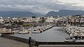 Port
Port Beach in the evening
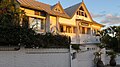 Hotel Villa Morgane
 Sunset


Twin towns-Sister cities
Saint-Pierre is twinned with Beau-Bassin Rose-Hill, Mauritius.
See also
References
- "Répertoire national des élus: les maires". data.gouv.fr, Plateforme ouverte des données publiques françaises (in French). 2 December 2020.
- "Populations légales 2019". The National Institute of Statistics and Economic Studies. 29 December 2021.
- "climate of Pierrefonds 1991-2020" (PDF) (in French). Météo-France. Retrieved September 7, 2022.
- "climate of Pierrefonds Aeroport 1991-2020" (PDF) (in French). Météo-France. Retrieved September 1, 2022.
- "climate of Ligne Paradis 1991-2020" (PDF) (in French). Météo-France. Retrieved August 31, 2022.
- "Normales / Moyennes 1981-2010 / Ligne-Paradis - Cirad (974)" (in French). Météo-France. Retrieved August 31, 2022.
- "Climate of Ravine des Cabris 1991-2020" (PDF) (in French). Météo-France. Retrieved September 6, 2022.
- FMEP – SAINT PIERRE PIERREFONDS. AIP from French Service d'information aéronautique, effective 8 September 2022.
- SPLAF (la Population et les Limites Administratives de la France). "Agglomérations et villes de la Réunion" [Towns and cities of Reunion Island]. Retrieved 23 February 2021.
- Population en historique depuis 1968, INSEE
External links
- Saint Pierre Official website (in French)
Authority control | |
|---|---|
| General | |
| National libraries | |
| Other | |
На других языках
[de] Saint-Pierre (Réunion)
Saint-Pierre ist eine französische Gemeinde des Übersee-Départements Réunion. Sie ist seit 1965 Hauptort (Unterpräfektur) des gleichnamigen Arrondissements. Saint-Pierre hat 84.982 Einwohner (Stand 1. Januar 2019) und gehört damit zu den 50 einwohnerreichsten Gemeinden Frankreichs. Saint-Pierre ist das Zentrum der Communauté d’agglomération Communauté Intercommunale des Villes Solidaires (CIVIS).- [en] Saint-Pierre, Réunion
[ru] Сен-Пьер (Реюньон)
Сен-Пьер (фр. Saint-Pierre) — коммуна в заморском департаменте Франции Реюньон.Другой контент может иметь иную лицензию. Перед использованием материалов сайта WikiSort.org внимательно изучите правила лицензирования конкретных элементов наполнения сайта.
WikiSort.org - проект по пересортировке и дополнению контента Википедии