world.wikisort.org - France
Floirac (French pronunciation: [flwaʁak]) is a commune in the Lot department (46) in south-western France.[2]
Floirac | |
|---|---|
Commune | |
 The Tower of Floirac | |
Location of Floirac  | |
 Floirac  Floirac | |
| Coordinates: 44°55′00″N 1°39′19″E | |
| Country | France |
| Region | Occitania |
| Department | Lot |
| Arrondissement | Gourdon |
| Canton | Martel |
| Intercommunality | Causses et Vallée de la Dordogne |
| Government | |
| • Mayor (2020–2026) | Alexandre Barrouilhet |
| Area 1 | 19.02 km2 (7.34 sq mi) |
| Population | 241 |
| • Density | 13/km2 (33/sq mi) |
| Time zone | UTC+01:00 (CET) |
| • Summer (DST) | UTC+02:00 (CEST) |
| INSEE/Postal code | 46106 /46600 |
| Elevation | 90–345 m (295–1,132 ft) (avg. 132 m or 433 ft) |
| 1 French Land Register data, which excludes lakes, ponds, glaciers > 1 km2 (0.386 sq mi or 247 acres) and river estuaries. | |
Geography
The commune is located in Quercy on the Causse of Floirac. It is watered by the Dordogne, and bordered to the north-west by its tributary, the Tourmente. Floirac has a surface of 19.02 km² and has 265 inhabitants (as of 2016), which makes a population density of 14 inhabitants per km². The coordinates are 44° 55' N and 1° 39' E. The altitude varies between 90 and 345 metres above sea level, with 140 metres at the town hall.[3][4] The D43 road and a single track railway crosses it.
Neighbouring municipalities
Places adjacent to Floirac, Lot | |
|---|---|
Toponymy
The toponym Floirac is based on the Gallo-Roman anthroponymy Florus. The endpoint -ac is derived from the Gallic -acon suffix (itself of the common Celtic *-Āko-), often latinized in-acum in the texts. This Floracum toponym is found in Floracum fundum which meant: the domain of Florus.
Politics
| Term | Name[3] |
|---|---|
| 2001–2014 | Frédéric Bonnet-Madin |
| 2014–2020 | Raphaël Daubet |
| 2020–incumbent | Alexandre Barrouilhet |
Places and monuments
 Entrance of the Chapelle Saint-Roch.
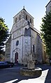 Church of Saint-Georges.
 Tour de Floirac.


- Chapelle Saint-Roch de Floirac (15th century) Listed as a historic monuments on 10 December 1925
- Church Saint-Georges de Floirac (15th century) Listed as a historic monuments on 30 May 1978
- Tour de Floirac, dating from the Middle Ages, registered in the title of historical monuments on 8 August 2013
Notable people
- Jean Dellac (1876-1937) French politician
- Raphael Daubet (1977-) French politician
- Max Pugh Film director and artist (1977-)
- Jean-Louis Ezine French writer and broadcaster
See also
References
- "Populations légales 2019". The National Institute of Statistics and Economic Studies. 29 December 2021.
- INSEE commune file
- Village de Floirac, annuaire-mairie.fr, accessed 22 March 2022
- "Résultat sur la commune : ' FLOIRAC ', Institut géographique national". Archived from the original on 2007-03-12. Retrieved 2008-06-03.
External links
- Official website
- Floirac en Quercy (in French)
Authority control | |
|---|---|
| General |
|
| National libraries | |
This Lot geographical article is a stub. You can help Wikipedia by expanding it. |
Другой контент может иметь иную лицензию. Перед использованием материалов сайта WikiSort.org внимательно изучите правила лицензирования конкретных элементов наполнения сайта.
WikiSort.org - проект по пересортировке и дополнению контента Википедии